NORTHERN
ROCKY MOUNTAIN
WILDFLOWERS
To buy books in quantity for corporate use or incentives, call (800) 962-0973 or e-mail premiums@GlobePequot.com.
FALCON GUIDES
Copyright 2001, 2012 Morris Book Publishing, LLC
ALL RIGHTS RESERVED. No part of this book may be reproduced or transmitted in any form by any means, electronic or mechanical, including photocopying and recording, or by any information storage and retrieval system, except as may be expressly permitted in writing from the publisher. Requests for permission should be addressed to Globe Pequot Press, Attn: Rights and Permissions Department, P.O. Box 480, Guilford, CT 06437.
FalconGuides is an imprint of Globe Pequot Press.
Falcon, FalconGuides, and Outfit Your Mind are registered trademarks of Morris Book Publishing, LLC.
Photos: H. Wayne Phillips
Illustrations: DD Dowden
Map: Trailhead Graphics, Inc. Morris Book Publishing, LLC
Project editor: Julie Marsh
Text design: Nancy Freeborn
Layout: Kirsten Livingston
Cataloging-in-Publication Data is on file at the Library of Congress.
ISBN 978-0-7627-7766-2
Printed in China
10 9 8 7 6 5 4 3 2 1
The author and Globe Pequot Press assume no liability for accidents happening to, or injuries sustained by, readers who engage in the activities described in this book. Neither the author nor the publisher in any way endorses the consumption or other uses of wild plants that are mentioned in this book, and they assume no liability for personal accident, illness, or death related to these activities.
T O M A R I L Y N, K E L L Y, S T E P H A N I E, A N D R E W, R O B,
J A M I E, N A Y A, S E A N, A N D E M M A
W I T H L O V E T O Y O U A L L.
ACKNOWLEDGMENTS
The most enjoyable part of writing this book has been the association with my wildflower-loving friends. Thanks so much to all of you for sharing your enthusiasm and knowledge of native plants, for your encouragement, and for your help with the critical local information on locations and flowering times for the plants that I wanted to find and photograph for the book. In some cases you have even assisted me in the field. Thanks especially to Lillian Pethtel and Michelle Craig of Kamiah, Idaho; Drake Barton and Kathy Lloyd of Clancy, Montana; Pattie Brown and Sam Culotta of Bigfork, Montana; Jerry DeSanto of Babb, Montana; Peter Stickney and Steve Shelly of Missoula, Montana; Earle and Pattie Layser of Alta, Wyoming; Maria Mantas and Steve Wirt of Whitefish, Montana; Dennis Nicholls and Jill Davies of Noxon, Montana; and Tom and Katie Kotynski of Great Falls, Montana. For their generous assistance in identifying and verifying plant specimens, I owe a special debt of gratitude to Peter Stickney and Matt Lavin. Thank you very much.
Thanks to Susan Spady of Pro Photo in Great Falls for her fast and superior slide developing.
I am especially grateful to my wife, Marilyn Schneider, for her help in the field and her support patience, and understanding over the long days while I was chained to the word processor.
Most important, thanks to Bill Schneider of Falcon Publishing, Inc., for inviting me to write this book and for the support of editors Gayle Shirley, Julianna Schroeder, Laura Ottoson, Jessica Haberman, Julie Marsh, and the rest of the FalconGuides and Globe Pequot staff that assisted with this book.
INTRODUCTION
Geography
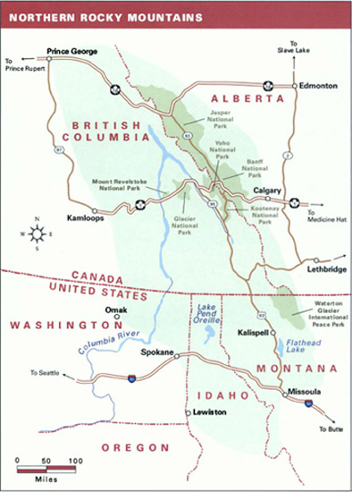
The Northern Rocky Mountain region is a land of forested mountain ranges interspersed with deep canyons and valleys. It includes northwestern Montana, northern Idaho, and northeastern Washington, and southeastern British Columbia and southwestern Alberta in Canada.
The region stretches from Lost Trail Pass on the Idaho-Montana border northward to Prince George, British Columbia, and from the Okanogan River in Washington and the Fraser River in British Columbia eastward to the eastern slope of the Rocky Mountains in Alberta and Montana. The southern boundary lies along the watershed divide between the Salmon and Clearwater Rivers in Idaho. The western boundary is a line drawn between Lewiston, Idaho; Spokane, Washington; Omak, Washington; Kamloops, British Columbia; and Prince George, British Columbia. The eastern boundary follows the eastern slopes of the Rocky Mountain Front from the Alberta-British Columbia border (east of Mount Buchanan) southeastward to Waterton-Glacier International Peace Park. It then follows the Continental Divide south to Scapegoat Mountain, turns westward and follows the Blackfoot River to Missoula, Montana, and then goes southward up the Bitterroot Valley to Lost Trail Pass.
In designating the Northern Rocky Mountain region, I have generally followed Robert G. Bailey's Description of the Ecoregions of the United States (1995). However, I have moved the southern boundary farther south to follow the Salmon-Clearwater watershed divide in Idaho. A significant change in climate and vegetation occurs along this line, as described by Ray J. Davis (1952) and Rexford Daubenmire (1968).
When compared with the valleys and peaks of the Central Rocky Mountains, those of the Northern Rockies are generally lower in elevation. Elevation extremes in the Northern Rockies range from less than 750 feet above sea level at the confluence of the Clearwater and Snake Rivers at Lewiston, Idaho, to 12,972 feet at the summit of Mount Robson in British Columbia. However, within the Northern Rockies in Washington, Idaho, and Montana (outside of Glacier National Park), few peaks rise above 7,000 or 8,000 feet in elevation. These mountains typically comprise a repetitive series of ridges and narrow V-shaped canyons, fully covered with dense forest on all but the highest ridges and summits. Slopes are often steep, with 3,000 to 5,000 feet or more of vertical relief between the valleys and summits.
The major mountain ranges within the area are:
Idaho: Bitterroot, Clearwater, Coeur d'Alene, Purcell, Selkirk, Selway, St. Joe.
Montana: Lewis, Livingston, Mission, Ninemile, Purcell, Rattlesnake, Reservation, Salish, Swan, Whitefish.
Washington: Kettle River, Okanogan, Selkirk.
Alberta: Rocky Mountains.
British Columbia: Cariboo, Columbia, MacDonald, Monashee, Okanagan, Purcell, Rocky, Selkirk, Shuswap.
The Northern Rocky Mountain region is the headwaters of five great river systems: the Columbia, Fraser, Peace, Athabasca, and Saskatchewan. However, most of the land drains into the Columbia River and its major tributaries: the Bitterroot, Clark Fork, Clearwater, Coeur d'Alene, Duncan, Flathead, Granby, Kettle, Kootenay, Okanagan/Okanogan, Pend Oreille, Saint Joe, Sanpoil, Spokane, and Swan Rivers.


