OTHER BOOKS IN THE 50 HIKES SERIES
50 Hikes in Michigan & Wisconsins North Country Trail
50 Hikes in the North Georgia Mountains
50 Hikes in Northern New Mexico
50 Hikes in Ohio
50 Hikes in Orange County
50 Hikes in the Ozarks
50 Hikes in South Carolina
50 Hikes in the Upper Hudson Valley
50 Hikes in Wisconsin
50 Hikes in the Berkshire Hills
50 Hikes in Alaskas Kenai Peninsula
50 Hikes in Coastal and Inland Maine
50 Hikes in Kentucky
50 Hikes in the Catskills

AN INVITATION TO THE READER
Over time trails can be rerouted and signs and landmarks altered. If you find that changes have occurred on the routes described in this book, please let us know so that corrections may be made in future editions. The author and publisher also welcome other comments and suggestions. Address all correspondence to:
Editor, 50 Hikes Series
The Countryman Press
500 Fifth Avenue
New York, NY 10110
Copyright 2018 by the Countryman Press
Maps 2018 by the Countryman Press
All rights reserved
For information about permission to reproduce selections from this book, write to Permissions, The Countryman Press, 500 Fifth Avenue, New York, NY 10110
For information about special discounts for bulk purchases, please contact W. W. Norton Special Sales at specialsales@wwnorton.com or 800-233-4830
Series cover design by Steve Attardo
Cover photographs: (front) Rmbarricarte / iStockphoto.com; (back) Derek Dellinger
The Countryman Press
www.countrymanpress.com
A division of W. W. Norton & Company, Inc.
500 Fifth Avenue, New York, NY 10110
www.wwnorton.com
978-1-68268-096-4 (pbk.)
978-1-68268-097-1 (e-book)
Dedicated to everyone
who works to keep our public lands
preserved and pristine.
Contents
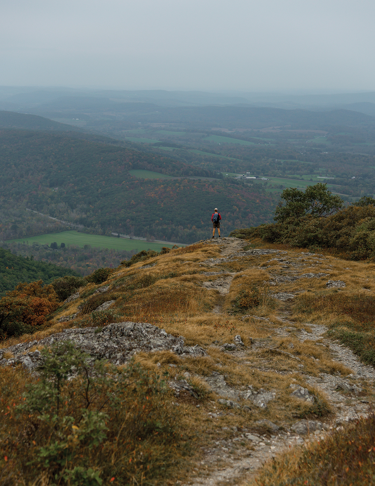
A HIKER ENJOYS THE VIEW FROM ALANDER MOUNTAIN
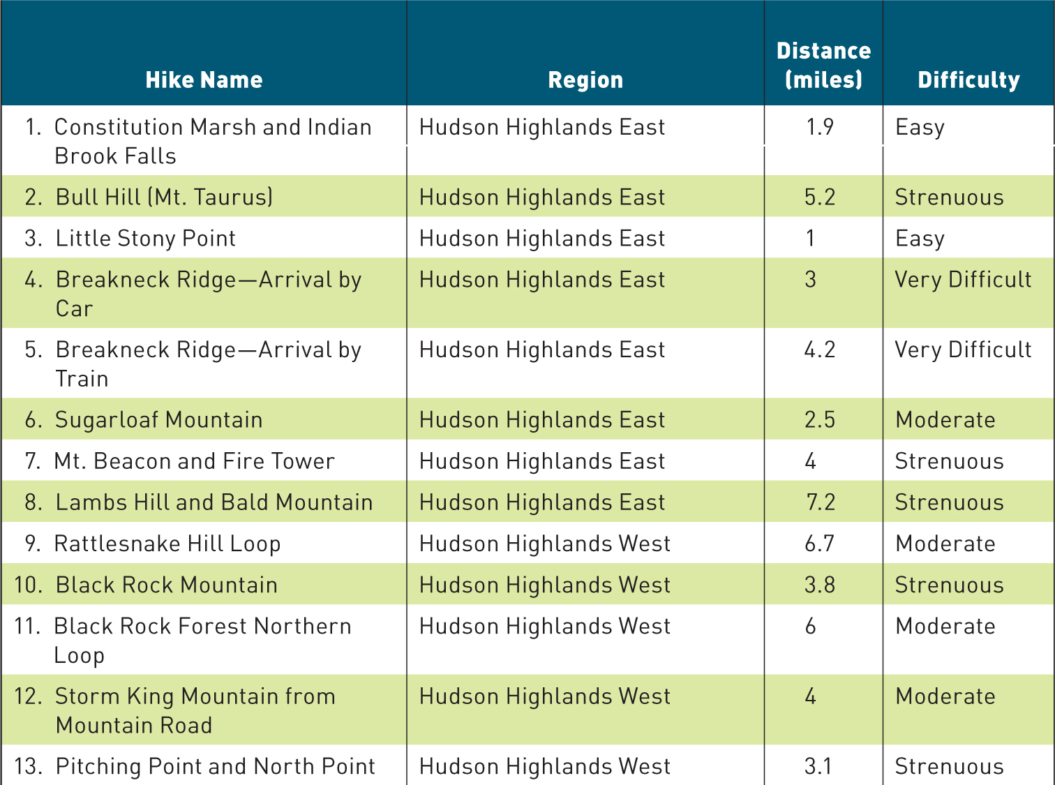
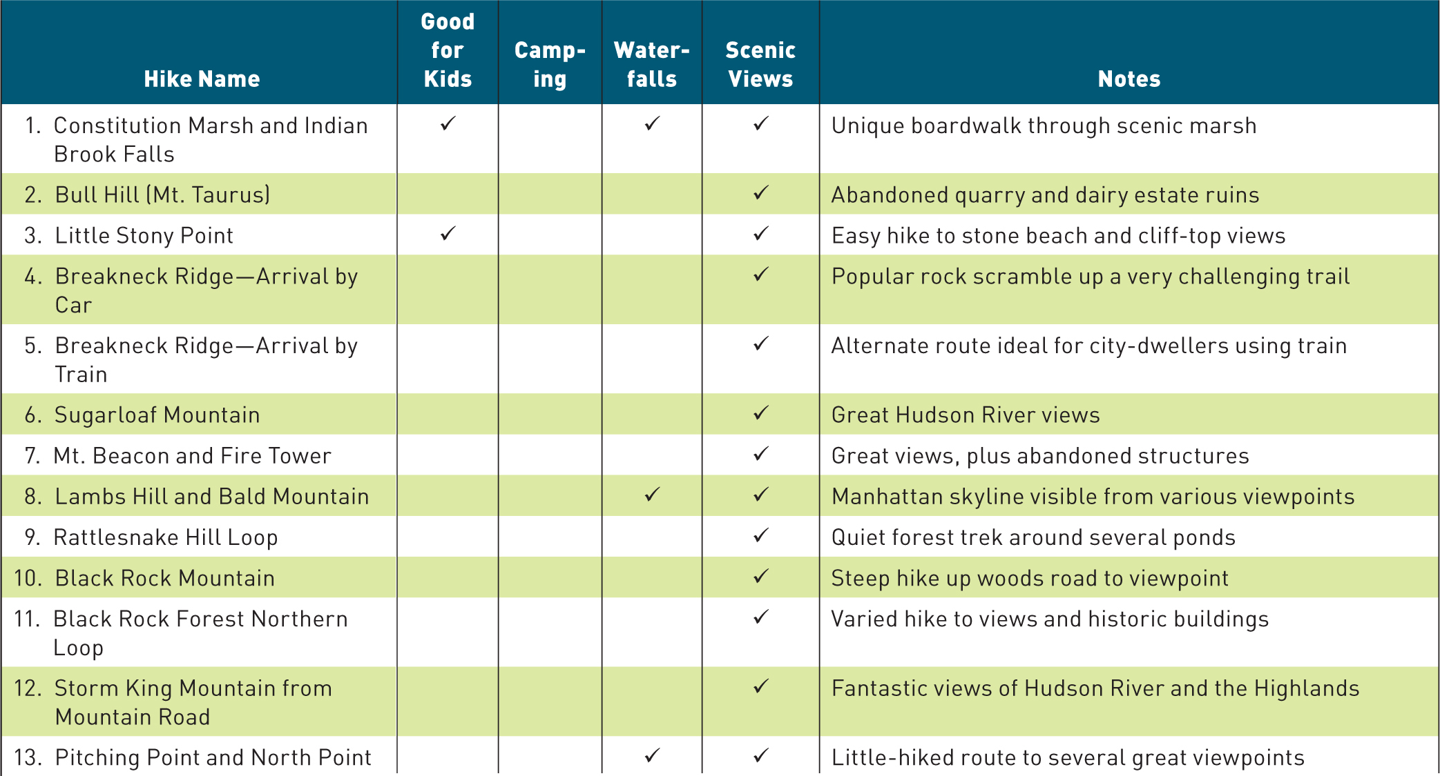
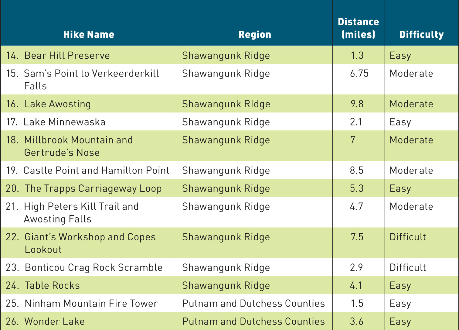
A NOTE ON DIFFICULTY RATINGS
While a hikers perception of the difficulty of a trail will always depend, more than any other factor, on the experience level of that hiker, some trails undeniably require more effort than others. In general, Easy hikes are those which can be completed in only a few hours, with a minimum of exertion. Moder ate hikes may be slightly longer, and will likely include several sections of steep uphill, though nothing that an inexperienced hiker could not handle. For the purposes of this guide, elevation gain and the steepness of the trail have been given the greatest considerationa long route of 8 to 10 miles that follows a mostly level, easily-walked carriage path, therefore, will rank as easy to moderate. Strenuous trails are those which, due to their steep incline, will result in a great deal of sweating and huffing and puffingeven for experienced hikers. However, a strenuous trail may be no more than a simple woods road, easily walked and posing no technical challenges, that simply happens to be very steep. Trails rated as Difficult begin to demand more serious uphill climbing, may include some sections of challenging trail, and will likely be tackled over the course of a full morning or afternoon. For the final, most challenging tier of hikes, Very Difficult hikes are those which are both strenuousyoull sweat a lotand also pose a level of technical difficulty, with areas of rock scrambling and steep, narrow trail. However, no hikes in this guide require any specialized climbing equipment when hiked in good weather.
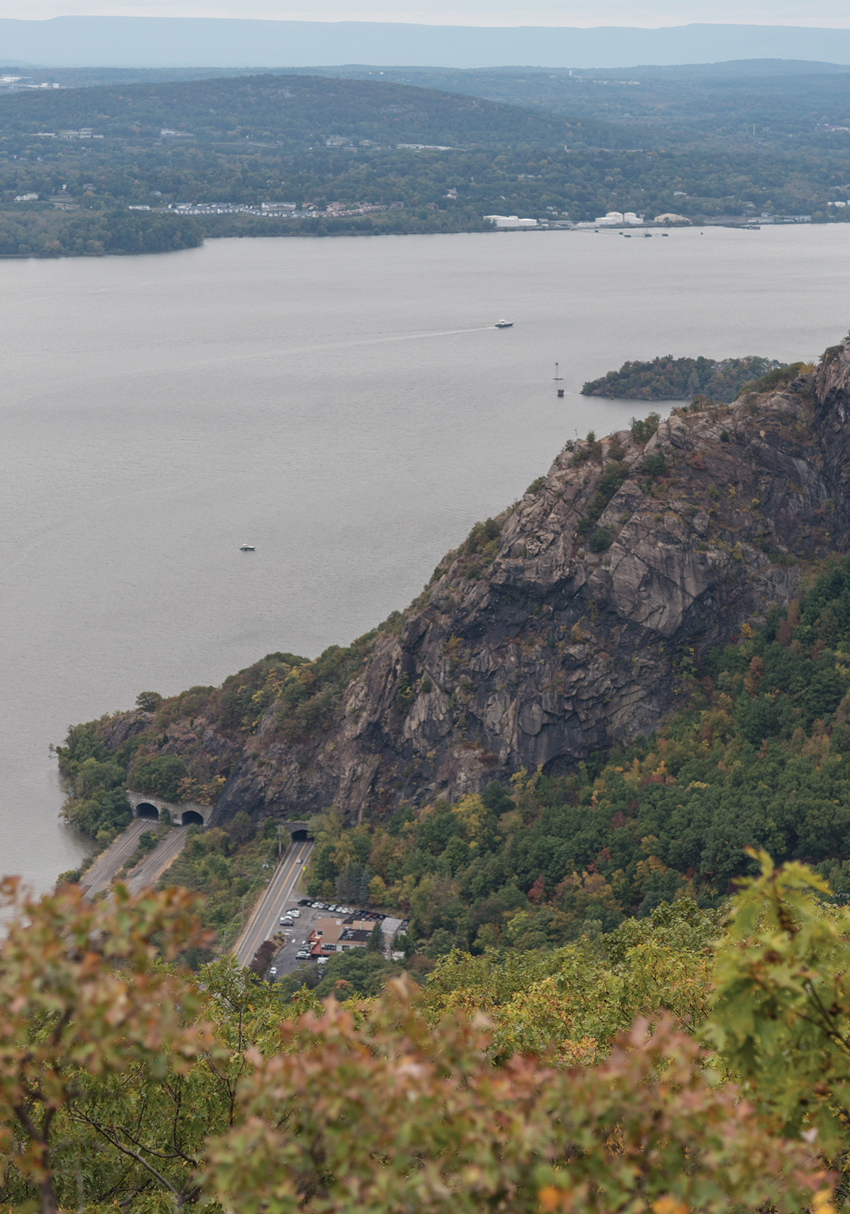
THE INITIAL ASCENT UP BREAKNECK RIDGE, GLIMPSED IN PROFILE FROM BULL HILL (MT. TAURUS)
B reakneck Ridge is one of the most technically challenging and strenuous hikes in the northeastern United States, barely giving hikers more than a few feet of trail to acclimate to before dashing them against the hikes main scramblean abrupt, unflinching climb over half a mile of near-vertical boulders and cliff edges. While the trail is never so difficult as to require technical climbing gear, the scramble is sure to push the limits of most hikers. Given that, it is somewhat odd that Breakneck Ridge is, in fact, the hike that introduces so many adventurers to hiking in the Hudson Valley.
On a nice weekend day, thousands will tackle the climb up Breakneck Ridge. That the unique challenges of the trail and its jaw-dropping viewpoints begat notoriety isnt surprising, but perhaps the most important factor in cementing Breakneck Ridges popularity is the fact that this hike is easily accessible from New York City. In fact, Breakneck Ridge has its own dedicated Metro-North train stop, which deposits large hordes of hikers every weekend. Judging by the increasingly dire warnings posted around the trailhead, many of these hikers have no idea what theyre getting themselves into. For the prepared adventurer, this hike can be exhilarating and memorable. Revisiting the trail never becomes repetitious: the myriad routes and challenging configurations spike your adrenaline every time. But for the unpreparedunaware just how strenuous and intimidating this climb will beBreakneck Ridge occasionally leads to defeat.
Perhaps there is a certain appeal to breaking yourself in with one of the most difficult hikes in the Hudson Valley. I was one of those oblivious hikers myself, years agolike so many others, Breakneck Ridge was my (possibly ill-advised) introduction to hiking here. At the time, I was a college student in Poughkeepsie. One April weekend, a friend told me we were going on an adventure. We drove to a place far from campus that Id never heard of before, seemingly in the middle of nowhere. All I knew was that it was about 45 minutes from Poughkeepsie. All I was told was that we would be climbing over rocks, more so than I was probably used to.
An hour later, I was clinging for dear life to the side of a steep rock face that appeared to have no handholds, no grip, and no possible safe route up. I told my friend that she would have to leave me there, to start a new life as a hermit on the side of that cliff. There was certainly no way I was making it up, and turning back was probably a suicide mission, given the severe grade of the climb wed already undertaken.
Next page
