Ted Alvarez is Backpacker magazine's Northwest Editor and was a National Magazine Award finalist in 2014. Whether chasing grizzly bears in the North Cascades, fording an icy Alaska river, or drinking his own urine in the desert, he regularly goes to extreme lengths in pursuit of a good storyoften in our national parks. He lives in Seattle, Wash., where he survives on heroic doses of strong coffee.
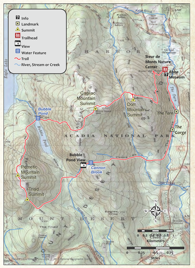
Summit three Acadia peaks on an 8.8-mile loop, traversing the rugged topography of Mount Desert Island and passing overlooks of neighboring bays and island clusters along Maines coastline.
A t 1,530 feet, Cadillac Mountain Is Acadia National Park's highest point and the tallest peak on the eastern seaboard. But because of the peak's height, position, and longitude, Mount Desert Island's flat summit is also among the first places in the country to see the sun rise. Even when not gilt with the nation's first light, it's a fine showcase for the deep green forests, glassy ponds, pink granite ramps, and wide ocean views that define the first national park in the eastern United States.
Yes, there's a road to the summitbut let the pikers drive to the top. This 8.8-mile loop avoids the RV crowds and lets you summit three peaks over 1,000 feet. From the Sieur de Monts Spring Nature Center, head southwest on a trail that switchbacks up the wooded lower slopes of Dorr Mountain. Along the way, you'll catch intermittent views of the Porcupine Islands and Frenchman Bay. Midway up the mountain, the trail traverses south before steepening to crest Dorr's summit (1,270 feet). From here, hikers will drop down into a rocky gully on the west face before clambering up through the large granite boulders littering the ascent on the east ridge of Cadillac Mountain. At the top, expansive views of the Atlantic stretch off to the south; constellations of islands stretch to the horizons. Stop for lunch or explore the multiple side trails spidering off Cadillac's summit.
To continue the loop to 1,248-foot Pemetic Mountain, follow a wide gravel road 100 feet from the visitor center down the west face of Cadillac Mountain. Go right at a three-way junction to descend to Bubble Pond, where still waters reflect rounded peaks ringing the placid pool. Nearby, fast-flowing Bubble Brook is a great spot to tank up. Next, follow signs on the bike path for Pemetic Mountain; a gradual climb through forest canopy eventually widens to the open, rock-slab summit. After descending this third peak, the trail climbs to the top of one more ridge before descending along Canon Brook and heading north past the Tarn and back to the Sieur de Monts Spring Nature Center where you began.
BONUS FOR EARLY RISERS: Start well before dawn and you'll beat the crowds and catch a spectacular summit sunrise.
DISTANCE: 8.8 miles
TIME REQUIRED: 1 day
DIFFICULTY: Intermediate
CONTACT: Acadia National Park, (207) 288-3338; nps.gov/acad
THE PAYOFF: Three broad summits high above an island-speckled Sea.
TRAILHEAD GPS: 44.3622512817383, -68.2080230712891
FINDING THE TRAILHEAD: From Cottage Street and Main Street in Bar Harbor, head south on Main Street/ US 3/Acadia Byway. In 2.3 miles, turn right onto Acadia Byway. In 0.1 mile, turn left into the Sieur de Monts Spring Nature Center.
WAYPOINTS & DIRECTIONS
GPS: 44.362251, -68.208023 The loop starts behind the Sieur de Monts Spring Nature Center. Head southwest on the trail that switchbacks up the wooded slopes of Dorr Mountain.
GPS: 44.354568, -68.216143 Dorr Mountain summit.
GPS: 44.352306, -68.225807 Cadillac Mountain summit.
GPS: 44.349751, -68.240402 Continue left on the trail around Bubble Pond (the Bubble Pond parking area is to the right). Bubble Brook is a good source of treatable water for drinking if needed.
GPS: 44.335384, -68.245528 Pemetic Mountain summit.
GPS: 44.329239, -68.243134 Stay left at the Y junction, heading southeast. The Triad Trail on the right leads to the summit of the Triad.
GPS: 44.337818, -68.228844 Look northwest for a bird's-eye view of Bubble Pond.
GPS: 44.338428, -68.226936 Canon Brook.
GPS: 44.346851, -68.206146 The Gorge.
GPS: 44.351471, -68.205101 Continue straight at three-way junction, heading back toward Sieur de Monts Spring Nature Center. To the left, the Ladder Trail ascends Dorr Mountain. To the right Is a small parking area. Ahead, the trail travels alongside the western banks of the Tarn
GPS: 44.362059, -68.207802 Sieur de Monts Spring Nature Center.
GPS: 44.360893, -68.207717 Abbe Museum.
Ladders and iron rungs help you take a heart-pounding climbing route up Champlain Mountain to deep blue views of the Atlantic coast.
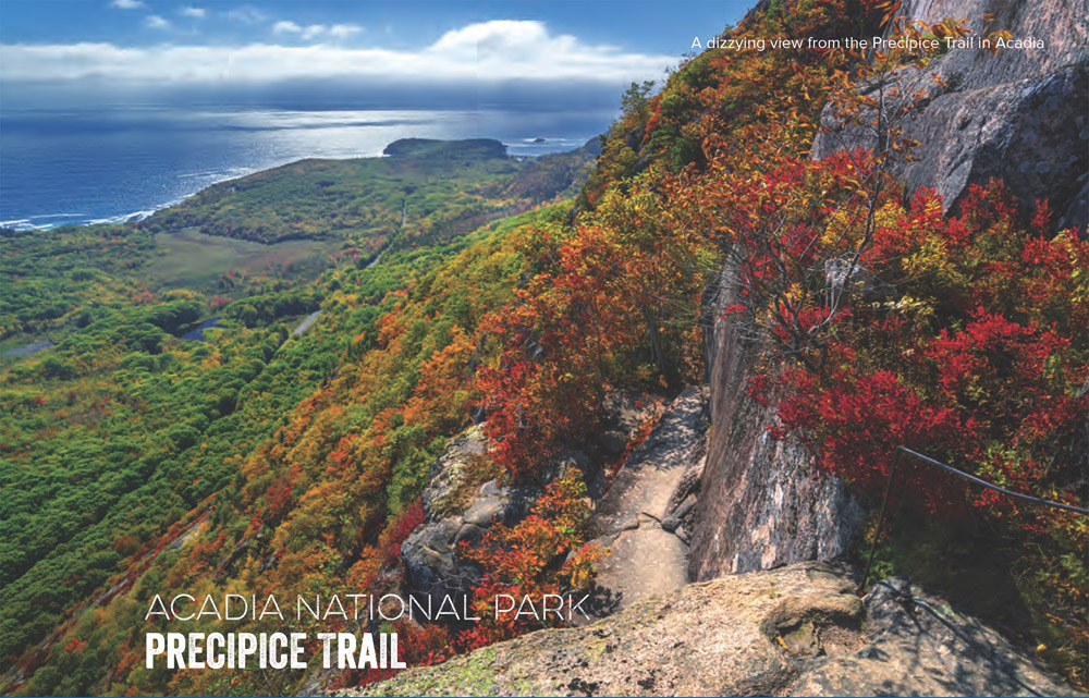
W hy simply hike a mountain when you can climb it? With ladders, iron rungs, and slender rock ridges to help you hoist yourself up 1,000 hair-raising feet, this route is more like a jungle gym than a trail. Luckily you don't need special gear to scale Champlain Mountain on the Precipice Trail, but a strong grip and nerves of steel won't hurt. Bonus: A spiking heart rate and big dose of adrenaline come free with the terrain.
The crucible comes early: A giant boulder bolted with iron rungs blocks the path. If you get the willies just thinking about climbing it, turn back. From here, an iron railing guides you across granite ledges and outcroppings. A wooden bridge spans an airy gap, and steps lead to the beginning of the proper climb. Scramble diagonally up a cliff band to reach a set of ladders and rungs that aid you where the rock goes vertical. Below you, rolling forest washes out to the sea's edge, but keep your eyes on the iron bars that trace faults and shelves in the cliff's face. A final set of ladders and rungs leads to an airy catwalk that swings out into space; face down this challenge and the last stretch is a simple uphill hike across the granite summit block. For the effort, you'll earn big views over an Atlantic coastline scattered with chunky granite islands and riddled with veiny inlets. Let your nerves cool on a hike back that connects the easy-breezy forest hike of Champlian North Ridge Trail to the roller-coaster granite steps of the Orange and Black Trail, which closes the loop.
DISTANCE: 2.6 miles
TIME REQUIRED: 1 day
DIFFICULTY: Intermediate
CONTACT: Acadia National Park, (207) 288-3338; nps.gov/acad
THE PAYOFF: Summit views on a ladder-assisted, white-knuckle climb.
TRAILHEAD GPS: 44.349479, -68.188075
FINDING THE TRAILHEAD: From the Sieur de Monts entrance, follow the one-way Park Loop Road two miles, until you see the sign for the Precipice Trail parking lot.


