CALIFORNIA CAMPING
TOM STIENSTRA
How to Use This Book
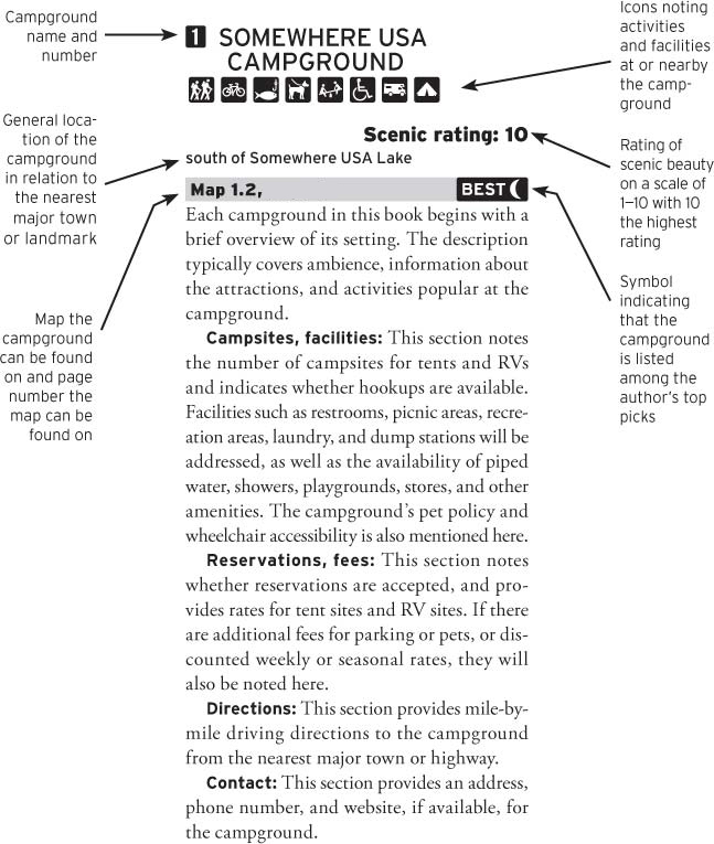
ABOUT THE CAMPGROUND PROFILES
The campgrounds are listed in a consistent, easy-to-read format to help you choose the ideal camping spot. If you already know the name of the specific campground you want to visit, or the name of the surrounding geological area or nearby feature (town, national or state park, forest, mountain, lake, river, etc.), look it up in the index and turn to the corresponding page. Here is a sample profile:
ABOUT THE ICONS
The icons in this book are designed to provide at-a-glance information on activities, facilities, and services available on-site or within walking distance of each campground.
 | Hiking trails |
 | Biking trails |
 | Swimming |
 | Fishing |
 | Boating |
 | Canoeing and/or kayaking |
 | Winter sports |
 | Hot springs |
 | Pets permitted |
 | Playground |
 | Wheelchair accessible |
 | 5 Percent Club |
 | RV sites |
 | Tent sites |
ABOUT THE SCENIC RATING
Each campground profile employs a scenic rating on a scale of 1 to 10, with 1 being the least scenic and 10 being the most scenic. A scenic rating measures only the overall beauty of the campground and environs; it does not take into account noise level, facilities, maintenance, recreation options, or campground management. The setting of a campground with a lower scenic rating may simply not be as picturesque as that of a higher rated campground, however other factors that can influence a trip, such as noise or recreation access, can still affect or enhance your camping trip. Consider both the scenic rating and the profile description before deciding which campground is perfect for you.
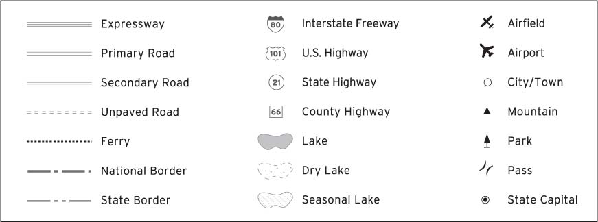
MAP SYMBOLS
ABOUT THE MAPS
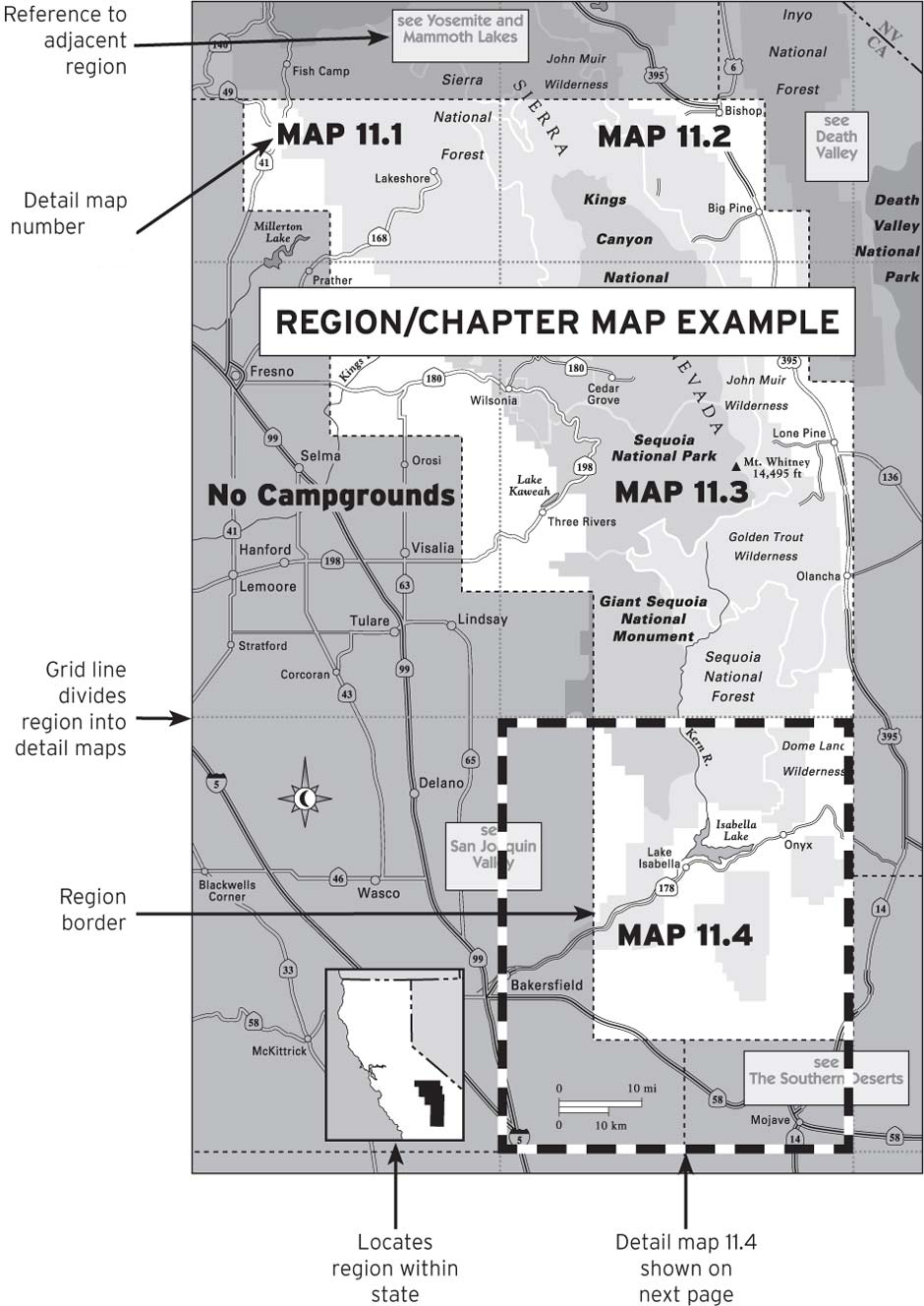
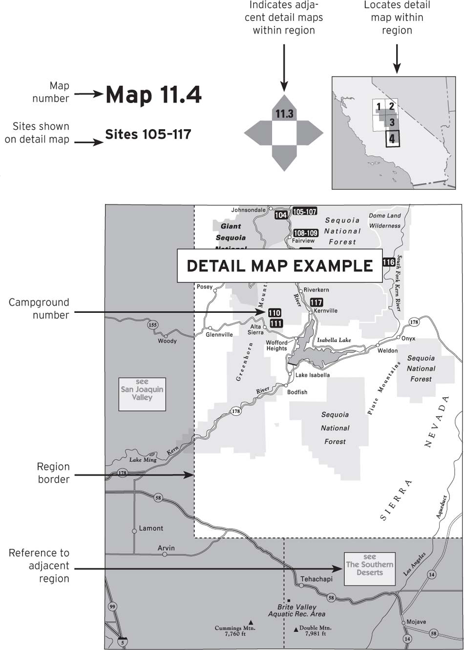
This book is divided into chapters based on major regions in the state; an overview map of these regions precedes the table of contents. Each chapter begins with a map of the region, which is further broken down into detail maps. Campgrounds are noted on the detail maps by number.
Going on a camping trip can be like trying to put hiking boots on an octopus. Youve tried it too, eh? Instead of a relaxing and fun trip full of adventure, it turns into a scenario called You Against the World. You might as well try to fight a volcano.
But it doesnt have to be that way, and thats what this book is all about. If you give it a chance, the information herein can put the mystery, excitement, and fun back into your camping vacationsand remove the snarls, confusion, and occasional, volcanic temper explosions that keep people at home, locked away from the action.
Mystery? There are hundreds of hidden, rarely used campgrounds listed and mapped in this book that most people have never dreamed of. Excitement? At many of them, youll find the sizzle with the steak: the hike to a great lookout or the big fish at the end of your line. Fun? The Camping Tips section of this book can help you take the futility out of your trips and put the fun back in. Add it up, put it in your cash register, and you can turn a camping trip into the satisfying adventure its meant to be, whether its just an overnight quickie or a monthlong expedition.
Its estimated that 95 percent of American vacationers use only 5 percent of the countrys available recreation areas. With this book, you can leave the herd, wander, and be free. You can join the inner circle, the 5 Percenters who know the great hidden areas used by so few people. To join the 5 Percent Club, take a hard look at the maps for the areas you wish to visit and the corresponding campground listings. As you study the camps, youll start to feel a sense of excitement building, a feeling that you are about to unlock a door and venture into a world that is rarely viewed. When you feel that excitement, act on it. Parlay that energy into a great trip.
The campground maps and listings can serve in two ways: 1) If youre on the road late in the day and youre stuck for a spot for the night, you can likely find one nearby; or 2) if you are planning a trip, you can tailor a vacation to fit exactly into your plans rather than heading off and hopingmaybe prayingit turns out all right.
For the latter, you may wish to obtain additional maps, particularly if you are venturing into areas governed by the U.S. Forest Service or Bureau of Land Management. Both are federal agencies that offer low-cost maps detailing all hiking trails, lakes, streams, and backcountry camps reached via logging roads. The Resources section at the back of this book details how to obtain these and other maps.
Backcountry camps listed in this book are often in primitive and rugged settings but provide the sense of isolation that you may want from a trip. They also provide good jump-off points for backpacking trips, if thats your calling. These camps are often free, and I have listed hundreds of them.
Next page

