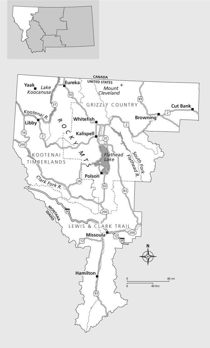
Boasting the terrific city of Missoula, world-famous Glacier National Park, and the skiing-golfing-boating mecca of Flat-head Valley, it is no surprise that Glacier Country is Montanas preeminent tourism region. An area of stunning natural beauty, it is graced with forested mountains and lush valleys teeming with fish-filled lakes and streams.
Although you can jump in and join the narrative at any point, well begin in the timbered vastness of the Yaak River Valley, nestled in the extreme northwest corner of Montana. From there, forest roads wind their way to Eureka, from which point Highway 37 leads to Libby and US 2. Youll then follow Highway 56 as it snakes through the memorable Bull River Valley, a tangle of wild terrain that would not appear out of place in Alaska, to the valley of the Clark Fork River and Highway 200. After going through Thompson Falls and Paradise, where the Flathead River joins with the Clark Fork, youll travel to the Mission Valley and along the shores of massive Flathead Lake. From there it is on to Kalispell and Whitefish, jumping-off point for Glacier National Park and the Blackfeet Indian Reservation. Finally, Highway 83 takes you through the forested, lake-adorned Seeley-Swan Valley to a juncture with
GLACIER COUNTRY
Highway 200, which leads west to Missoula. From Montanas unofficial capital of art and recreation and undisputed bastion of liberalism, US 93 leads south up the Bitterroot Valley to Lost Trail Pass, from which point youll descend into Gold West Country.
The remote Yaak River Valley, occupying the northwest notch of Montana, is home to the settlement of Yaak, a tiny island of enterprise set amid a rolling sea of timber. Road warriors who enjoy visiting places seen by relatively few travelers should not miss venturing into the Yaak River country. Not many places remaining in the contiguous 48 can claim to be more off the beaten path than this isolated corner of the Big Sky State.
AUTHORS FAVORITES
A Carousel for Missoula
Missoula
carouselformissoula.com
(406) 549-8382
Clearwater Canoe Trail
Seeley Lake
(406) 677-2233
Dirty Shame Saloon
Yaak
(406) 295-5100
Garden Wall Inn
Whitefish
gardenwallinn.com
(406) 862-3440
Hornet Peak Fire Lookout
Polebridge
recreation.gov/camping/campgrounds/234341
(406) 387-3800
Ninepipes Museum of Early Montana History
Charlo
ninepipesmuseum.org
(406) 644-3435
Lee Metcalf National Wildlife Refuge
Stevensville
fws.gov/leemetcalf
(406) 777-5552
Montana Valley Bookstore
Alberton
montanavalleybookstore.com
(406) 722-4950
St. Ignatius Mission
St. Ignatius
(406) 745-2768
Wild Horse Island State Park
Big Arm
(406) 752-5501 (winter), (406) 849-5256(summer)
If you do find your way to the town of Yaak, you cant miss the Dirty Shame Saloon, a funky bar and eatery with a decor to match the kicked-back and independent character of the majority of local residents. Yaak is situated along Highway 508, 30 miles northeast of US 2 (beginning 3.5 miles southeast of the point where US 2 crosses the Montana-Idaho state line). The Dirty Shames phone number is (406) 295-5100.
The Yaak River drains a large portion of the Purcell Mountains, a range teeming with ancient coniferous forests and not-so-ancient clear-cuts. The Yaak, as the surrounding countryside is typically referred to, is a backwoodsy backwater that has attracted an eclectic mix of human residents, including back-to-the-land Mother Earth types, artists and writers, tree fellers, tree huggers, and plain old hermits. As diverse as the homesteaders are, though, all share this trait: They enjoy getting away from it all and being left alone. Either that or they dont last long in the isolated Yaak River country.
While up the Yaak, as the locals say, consider also following Pete Creek to Hawkins Lakes and the Northwest Peaks Scenic Area, a spectacular setting of rocky crags, sparkling lakes, and sky-scratching peaks reaching more than 7,700 feet above sea level. The area, roughly 19,000 acres in size, is like a miniature and little-visited version of Glacier National Park, and its ideal for hiking, picnicking, and car camping. Getting there is a journey in itself, for from the already remote outpost of Yaak, it is 3 miles west on Highway 508, then 22 miles north and west on FR 338 (12 miles paved and 10 dirt). Call the Three Rivers Ranger District at (406) 295-4693 for maps and information.
Also worth the trip is West Fork Falls, gracing the West Fork of the Yaak River. The falls are found at the end of a short trail that begins in a parking area near the 39-mile marker on the Yaak River Road. The falls and the deep, amazingly clear pool they feed can be viewed from a wooden observation deck, built courtesy of the Kootenai National Forest.
In the town of Eureka, just east of the Yaak area, is the Tobacco Valley Historical Village, featuring structures dating from the 1880s through the 1920s. The Peltier log home (Eurekas first residence) and the Rexford train depot are located here, as are a vintage hand-hewn log ranger cabin, a one-room school, the old Fewkes Storewith works by local artists on saleand several other buildings, all connected by a stout boardwalk. The museum houses artifacts and interpretive displays illustrating the Kootenai Indians movement through the region and the Eureka areas logging heritage. Theres no charge to visit the historical village, open daily Memorial Day through Labor Day at S. Main Street. Call (406) 889-3492. (The US portion of the Great Divide Mountain Bike Route runs past the village and starts not far north of town; see the sidebar on page 71 for more on this popular trail.)
One mile west of US 93 on the Fortine Creek Road, 12 miles south of Eureka, is the Ant Flat Natural Resource Education Center and Historic Site. Location of the first Forest Service administrative activities in the area, Ant Flat features several historic buildings, picnic grounds, and a mile-long nature trail. The first portion of the trail is wheelchair accessible, ending at a boardwalk and observation deck that extend out over a vibrant wetland. Its a great spot for bird-watching and mosquito-slapping! Contact Murphy Lake Ranger Station at (406) 882-4451 or fs.usda.gov/kootenai for more information on the site, which is listed on the National Register of Historic Places and open in summer only.
montana trivia
The Nature Conservancys Dancing Prairie Preserve, outside Eureka, is one of the Mountain Wests few remaining leks, or dancing and mating grounds, of the formerly abundant Columbian sharp-tailed grouse. The birds are unable to thrive in grasslands that have been altered by the plow or grazed by cattle.
Libby Logger Days, the premier summerfest in Lincoln County, celebrates the heritage of Lincoln Countys most important industry. Professional and amateur loggers alike test their skillsor lack thereofas woodsmen and woodswomen in competitions such as the double-buck saw and the Bull of the Woods boxing challenge. Non-loggers neednt feel left out, for also on tap are a parade, foot and bicycle races, water fights, a rafting competition, a carnival, and more. Logger Days are held in late June. Email .
Libby townsfolk have suffered tremendously in recent years, with the discovery that many of the people associated with the venerable vermiculite-mining industry were exposed to and poisoned by asbestos. But this is a town filled with survivors; Libby has a legacy of dealing with adversity, facing as it has the on-again, off-again nature of the timber industry. Dont hurry through town; take some time to mosey around the side streets and have a look. One treasure you may come across is the


