TASMANIA Tasmania is Australias smallest and most mountainous state, yet it boasts 20 national parks, 400 reserves and more walking trails than roads. With over twenty percent of the state protected within national parks, from alpine lakes and rainforests to massive sea cliffs and pure white-sand beaches, it is not surprising that it is one of the worlds top bushwalking destinations. The state's four largest national parks Southwest, FranklinGordon Wild Rivers, Cradle MountainLake St Clair and Walls of Jerusalem comprise a vast World Heritage area. This is one of the last great temperate wilderness areas on Earth, with untamed rivers, glaciated mountains, buttongrass plains and ice-age archaeological sites. The 1.38-million-hectare World Heritage area also includes Tasmania's smallest national park, the 1345-hectare Mole Creek Karst.
 | Parks and Wildlife Service (PWS) 1300 135 513
www.parks.tas.gov.au |
CONTENTS
FEATURE PARKSOTHER PARKS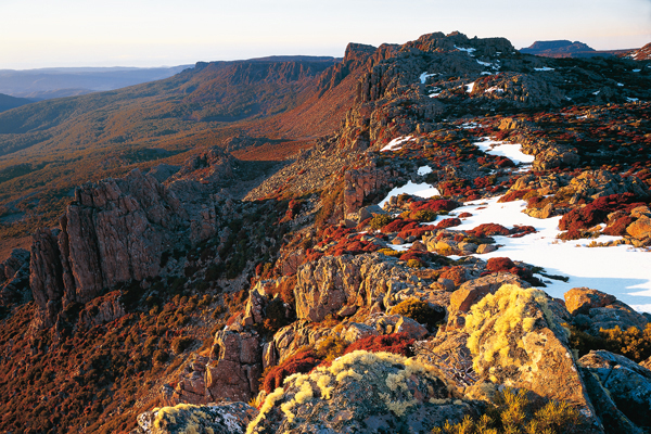
Spectacular alpine scenery is a feature of the park
PARK INFORMATIONPWS 1300 135 513 | PWS Tamar Field Centre (03) 6226 5397 | Snow cover www.ski.com.auSIZE18 190 haLOCATION230 km north of Hobart; 60 km east of LauncestonACCESSFrom Launceston via C401 to White Hills then C432; from Hobart via Midland Hwy then Evandale, C413 to Blessington, then C420, C401, and C432PERMITSPark entry fee payable by self-registration at park entranceBEST SEASONWinterVISITOR INFORMATIONEvandale (03) 6391 8128 | Launceston 1800 651 827MUST SEE, MUST DOMARVEL at the breathtaking view from the platform at the top of Jacobs LadderHIKE to Legges Tor from Carr Villa, retracing the steps of early skiersENJOY skiing on northern Tasmania's only downhill ski field Ben Lomond National Park, enclosing the largest alpine plateau in the state, is a mountain environment with extensive and dramatic dolerite cliffs and columns.
 | Parks and Wildlife Service (PWS) 1300 135 513
www.parks.tas.gov.au |
CONTENTS
FEATURE PARKSOTHER PARKS
Spectacular alpine scenery is a feature of the park
PARK INFORMATIONPWS 1300 135 513 | PWS Tamar Field Centre (03) 6226 5397 | Snow cover www.ski.com.auSIZE18 190 haLOCATION230 km north of Hobart; 60 km east of LauncestonACCESSFrom Launceston via C401 to White Hills then C432; from Hobart via Midland Hwy then Evandale, C413 to Blessington, then C420, C401, and C432PERMITSPark entry fee payable by self-registration at park entranceBEST SEASONWinterVISITOR INFORMATIONEvandale (03) 6391 8128 | Launceston 1800 651 827MUST SEE, MUST DOMARVEL at the breathtaking view from the platform at the top of Jacobs LadderHIKE to Legges Tor from Carr Villa, retracing the steps of early skiersENJOY skiing on northern Tasmania's only downhill ski field Ben Lomond National Park, enclosing the largest alpine plateau in the state, is a mountain environment with extensive and dramatic dolerite cliffs and columns.
Its scree slopes, swirling mists and frost-stunted forests are reminiscent of a Tolkien landscape. Aboriginal culture The park was part of the traditional lands of the Ben Lomond tribe, whose clans occupied the foothills of the mountain and the plains around it. One tribal member, Walter George Arthur, was an activist who petitioned Queen Victoria for Aboriginal rights from his place of exile on Flinders Island. A look at the past Ben Lomond was named in 1804 after a mountain in Scotland, and a year later Colonel W.V. Legge explored and named the various peaks that surround it. Skiing became popular in the 1930s and the first hut at Carr Villa was built in 1932 by enthusiastic skiers who carried their skis to the plateau (the first ski tow was not built until 1964).
The alarmingly steep zigzag Jacobs Ladder road, completed in 1966, rises some 150 metres between sheer cliffs in a series of hairpin bends, or switchbacks, that are so memorable they have individual names. Natural features The park encloses the foothills and peaks of the Ben Lomond plateau, a massive block of dolerite uplifted from the surrounding country about 55 million years ago, and rising to 1574 metres at its highest point Legges Tor, Tasmania's second-highest peak. Native plants There are 222 species of plants in the park. The foothills support extensive eucalypt forests of gum-topped stringybark (alpine ash or Eucalyptus delegatensis), messmate stringybark and white gum, while celery-top pine is found at the low to middle elevations. In protected areas sassafras, myrtle and the state's famous deciduous beech, Nothofagus gunnii, are found at the treeline, along with the very hardy alpine cider gum (E. archeri).
Other high-altitude species are cheeseberry, mountain pepper and mountain currant bush. The alpine moors support snow daisies, mountain berry and the rock cushion plant, a very rare species only found in one small area of this park. Wildlife Common wombats are numerous and their telltale scats (cube-shaped so that they do not roll away) are used to mark out their territories. Also present are ringtail and brushtail possums, Bennett's wallabies, Tasmanian pademelons, forester (eastern grey) kangaroos, Tasmanian bettongs, sugar gliders, long-nosed potoroos and eastern quolls. Endemic to the alpine areas of northern Tasmania, the northern snow skink favours rocky, water-edged habitats. Camping and accommodation There is one campground (6 sites, no power) only, located 1 kilometre inside the park boundary, with toilets and drinking water. Camping and accommodation There is one campground (6 sites, no power) only, located 1 kilometre inside the park boundary, with toilets and drinking water.
Campers must bring fuel stoves and can bush camp anywhere in the park (500 metres away from any road). Up on the mountain there is a motel offering unit accommodation, and there are a number of private lodges and ski clubs. Bookings for all accommodation in the park can be made through the motel. Things to do This is a popular, snow-covered winter destination, set up for skiers. Wheel chains and antifreeze must be carried between June and September. In summer the park is beautiful but seldom visited, and at this time bushwalkers and sightseers often have the magnificent alpine scenery to themselves.
Weather conditions can deteriorate rapidly and walkers must be equipped for all conditions. At the top of the Jacobs Ladder road, a spectacular platform lookout has views over sheer dolerite cliffs to the switchback road below. The Creek Inn has a licensed restaurant on the mountain. BUSHWALKING Two walks follow cross-country ski routes and are marked by snow poles. Carr Villa to Alpine Village walk (1.5 hours one way, medium difficulty) heads up to the plateau and crosses the Land of Little Sticks before climbing to the Plains of Heaven where, at The Kremlin hut, the track divides, one branch heading down to the ski village and the other up to the runs just beneath Legges Tor. Alpine Village to Little Hell circuit (5 km, 1.5 hours return) leads to Little Hell and back, with great views across to Stacks Bluff.




 Spectacular alpine scenery is a feature of the park PARK INFORMATIONPWS 1300 135 513 | PWS Tamar Field Centre (03) 6226 5397 | Snow cover www.ski.com.auSIZE18 190 haLOCATION230 km north of Hobart; 60 km east of LauncestonACCESSFrom Launceston via C401 to White Hills then C432; from Hobart via Midland Hwy then Evandale, C413 to Blessington, then C420, C401, and C432PERMITSPark entry fee payable by self-registration at park entranceBEST SEASONWinterVISITOR INFORMATIONEvandale (03) 6391 8128 | Launceston 1800 651 827MUST SEE, MUST DOMARVEL at the breathtaking view from the platform at the top of Jacobs LadderHIKE to Legges Tor from Carr Villa, retracing the steps of early skiersENJOY skiing on northern Tasmania's only downhill ski field Ben Lomond National Park, enclosing the largest alpine plateau in the state, is a mountain environment with extensive and dramatic dolerite cliffs and columns.