John McCann - Stay alive -- find your way back eshort learn basics of how to use a compass & a map to find your way back home
Here you can read online John McCann - Stay alive -- find your way back eshort learn basics of how to use a compass & a map to find your way back home full text of the book (entire story) in english for free. Download pdf and epub, get meaning, cover and reviews about this ebook. City: Iola, year: 2012, publisher: Krause Publications, genre: Home and family. Description of the work, (preface) as well as reviews are available. Best literature library LitArk.com created for fans of good reading and offers a wide selection of genres:
Romance novel
Science fiction
Adventure
Detective
Science
History
Home and family
Prose
Art
Politics
Computer
Non-fiction
Religion
Business
Children
Humor
Choose a favorite category and find really read worthwhile books. Enjoy immersion in the world of imagination, feel the emotions of the characters or learn something new for yourself, make an fascinating discovery.

- Book:Stay alive -- find your way back eshort learn basics of how to use a compass & a map to find your way back home
- Author:
- Publisher:Krause Publications
- Genre:
- Year:2012
- City:Iola
- Rating:4 / 5
- Favourites:Add to favourites
- Your mark:
Stay alive -- find your way back eshort learn basics of how to use a compass & a map to find your way back home: summary, description and annotation
We offer to read an annotation, description, summary or preface (depends on what the author of the book "Stay alive -- find your way back eshort learn basics of how to use a compass & a map to find your way back home" wrote himself). If you haven't found the necessary information about the book — write in the comments, we will try to find it.
John McCann: author's other books
Who wrote Stay alive -- find your way back eshort learn basics of how to use a compass & a map to find your way back home? Find out the surname, the name of the author of the book and a list of all author's works by series.


Stay alive -- find your way back eshort learn basics of how to use a compass & a map to find your way back home — read online for free the complete book (whole text) full work
Below is the text of the book, divided by pages. System saving the place of the last page read, allows you to conveniently read the book "Stay alive -- find your way back eshort learn basics of how to use a compass & a map to find your way back home" online for free, without having to search again every time where you left off. Put a bookmark, and you can go to the page where you finished reading at any time.
Font size:
Interval:
Bookmark:

1998 Tim Bottomley
Navigation skills are essential for survival and you should be well versed in using both a map and compass. Either one will assist you in the ability to navigate, but together they are a team that cant be beat. This chapter provides the basics of how to select the proper equipment, and what a map and compass can do for you. Although the basics of use are provided, I highly suggest that you take a good course where you can get hands-on instruction. The use of a map and compass takes practice, and there are no shortcuts.
A map is nothing more than a pictorial representation of the surface of the earth, drawn to scale and reproduced in two dimensions. If you are a driver, you know there are all kinds of maps, such as road maps, etc. Although these maps can get you from one place to another using the highway system, when you go into the wilderness, they are of little use. What you need is a topographical map.
Although there are many makers of topographical maps, we will limit our discussion to USGS maps with a scale of 1:24,000. The smaller the number to the right of the 1 in the scale of a map, the more detail you will find. Although larger scale maps show a larger area, for the purpose of navigation, I suggest a map with a 1:24,000 scale which provides enough detail to be usable.
A topographical map provides a three-dimensional representation, viewed from overhead. It portrays terrain and landforms in a measurable form using contour lines. However, before we get in to the specifics of contours, a discussion of the information provided on a maps borders, and colors used to identify specific features, is important.
Symbols and colors
The symbols give a quick visual description of things that appear on a map. An example is a small black square with a cross on top, which denotes a church. Some maps provide some of the symbols in a legend at the right bottom of the map. USGS maps use so many symbols that they provide a separate sheet called Topographical Map Symbols. If you dont want to carry this sheet with you, become familiar with the major symbols used so you can identify them on your map.
USGS maps are printed in seven colors. Color is used to more easily identify specific information or features. The following describes each color and what it represents:
White: An area of none or little vegetation, cleared land, desert, rocky areas.
Green: An area of substantial vegetation, forest, brush, orchards, etc.
Blue: Water such as ponds, lakes, rivers, canals. Note: A green area with small blue tufts of grass indicates a marsh or swamp.
Brown: Contour lines showing elevation.
Black: Manmade objects such as buildings, railroads, water towers, roads, and all names.
Red: Prominent roads and survey lines.
Purple: Revisions and updates added from aerial photographs (not field checked).
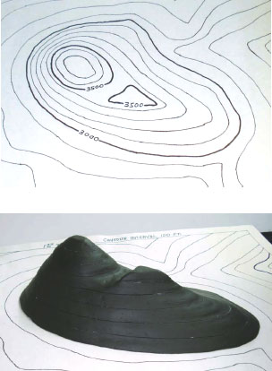
A mountain is built by adding one contour line section at a time. The result is an actual view of the mountain the contour lines represent.
Contour lines
Topographical maps have a bunch of little brown squiggly lines which are called contour lines. They represent the elevation above sea level for all land features. The difference in elevation between each contour line remains the same on a specific map. This allows you to view the topography in three dimensions, but you have to understand how to read them.
Certain rules pertain to all contour lines. If we understand the rules, then we better understand what contour lines show us.
The height, or vertical distance, between each contour line, known as the contour interval, is indicated at the bottom center of a map, below the scale. If it has a contour interval of 20 feet, then the vertical distance between each line either increases or decreases by 20 feet. Each fifth line will be thicker and will notate the actual elevation for that line.
If you continue to cross contour lines that increase in number, then you are going uphill. If the numbers decrease, then you are going downhill.
Contour lines have no beginning or end. No matter how irregularly shaped they are, they are all a closed loop. The entire line is at the exact same height and you could follow it around until you came back to where you started and never go up or down in elevation.
The closer the space between contour lines, the steeper the slope. A gentle slope is represented by the contour lines being spaced farther apart from one another. However, if the lines are spaced very close together, it indicates a very steep topography, such as a cliff.
V-shaped lines that face uphill, increased elevation, indicate a valley, ravine, etc., and always point upstream. V or U shaped lines that point downhill indicate a ridge or spur.
An hourglass shape with increasing numbered contour lines on each side indicates a saddle or pass.
The peak of a hill or mountain is normally marked with an X or the actual elevation.
Remember that not all topography is shown on a map. If the contour interval is 20 feet and there is a decrease in height, but is less than 20 feet, then it will not appear on the map. I warn of this so you do not come to an 18-foot cliff and, because it does not appear on the map, start questioning where you are. Being the cliff is less than 20 feet (or whatever the contour interval is for that map) it wont appear on the map.
Students find contour lines difficult to comprehend at first. I often thought that if I could only take a section of a map and build a mountain depicting the various heights the contour lines represented, a student would better comprehend contour lines, as they could see a three dimensional representation of the lines. So finally, my wife and I spent a weekend, first hand drawing a section of a map with contour lines, and then building a mountain that could be assembled one contour line at a time. After cutting, carving and installing wooden pegs to hold it together in the proper position, we had what we needed for our students. A little paint and when our students see the mountain built, one contour line at a time, they always exclaim, Now I get it!
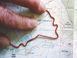
To measure distance of a curvy trail, bend a piece of wire to follow the trail, then straighten it and measure using the scale at the bottom center of the map.
As we learned above, the scale at the center bottom of the map provides a means to measure distance on a map. Unfortunately, you may not always want to measure with a straight line; you may want to measure the distance of a road or trail. My dad taught me to use a string, which could be wound around a trail, then straighten it out and measure it on the scale at the bottom of the map. However, always looking for a better way, I started using a piece of bendable wire, usually red in color. This way I can bend it around the trail, or whatever, and it stays in the shape until I need to straighten it for measuring.
Font size:
Interval:
Bookmark:
Similar books «Stay alive -- find your way back eshort learn basics of how to use a compass & a map to find your way back home»
Look at similar books to Stay alive -- find your way back eshort learn basics of how to use a compass & a map to find your way back home. We have selected literature similar in name and meaning in the hope of providing readers with more options to find new, interesting, not yet read works.
Discussion, reviews of the book Stay alive -- find your way back eshort learn basics of how to use a compass & a map to find your way back home and just readers' own opinions. Leave your comments, write what you think about the work, its meaning or the main characters. Specify what exactly you liked and what you didn't like, and why you think so.