Andrew Nugara - More Scrambles in the Canadian Rockies
Here you can read online Andrew Nugara - More Scrambles in the Canadian Rockies full text of the book (entire story) in english for free. Download pdf and epub, get meaning, cover and reviews about this ebook. year: 2014, publisher: eBOUND Canada;Rocky Mountain Books, genre: Home and family. Description of the work, (preface) as well as reviews are available. Best literature library LitArk.com created for fans of good reading and offers a wide selection of genres:
Romance novel
Science fiction
Adventure
Detective
Science
History
Home and family
Prose
Art
Politics
Computer
Non-fiction
Religion
Business
Children
Humor
Choose a favorite category and find really read worthwhile books. Enjoy immersion in the world of imagination, feel the emotions of the characters or learn something new for yourself, make an fascinating discovery.
- Book:More Scrambles in the Canadian Rockies
- Author:
- Publisher:eBOUND Canada;Rocky Mountain Books
- Genre:
- Year:2014
- Rating:3 / 5
- Favourites:Add to favourites
- Your mark:
More Scrambles in the Canadian Rockies: summary, description and annotation
We offer to read an annotation, description, summary or preface (depends on what the author of the book "More Scrambles in the Canadian Rockies" wrote himself). If you haven't found the necessary information about the book — write in the comments, we will try to find it.
The second edition of More Scrambles in the Canadian Rockies contains 49 new routes, in addition to the 65 of the first edition, along with a large collection of full-colour photos and maps. The regions of Waterton, The Castle and Kananaskis are covered comprehensively. Between this edition and Alan Kanes Scrambles in the Canadian Rockies, all of the major, named peaks in Waterton National Park are outlined. The Castle too is thoroughly covered, including a handful of terrific ascents around Middle Kootenay Pass and a new section for multi-peak baggers titled The Ultimate High-Level Ridgewalks. Several scrambles in other areas (Crowsnest, Banff, Highway 93 North and Yoho) are likewise new to this edition.
Andrew Nugara outlines several different routes to each summit and includes alternative and easier descents. Encompassing a range of levels of difficulty, the second edition of More Scrambles in the Canadian Rockies will appeal to anyone...
Andrew Nugara: author's other books
Who wrote More Scrambles in the Canadian Rockies? Find out the surname, the name of the author of the book and a list of all author's works by series.


More Scrambles in the Canadian Rockies — read online for free the complete book (whole text) full work
Below is the text of the book, divided by pages. System saving the place of the last page read, allows you to conveniently read the book "More Scrambles in the Canadian Rockies" online for free, without having to search again every time where you left off. Put a bookmark, and you can go to the page where you finished reading at any time.
Font size:
Interval:
Bookmark:
Rating easy; options to do some moderate scrambling
Round-trip time 69 hours
Elevation gain ~800 m for the full loop
Maps 82 H/4 Waterton Lakes; Gem Trek Waterton National Park
Lakeview Ridge shares a great deal in common with its northerly neighbour Prairie Bluff: both are on the very edge of the Front Ranges and look fairly boring from afar. However, they are wonderfully scenic trips with some of the best rock vistas you are ever likely to see in the area. The recommended route does not take the more obvious south or west ridge but instead goes to the southeast face, where the impressive rock sits. Early spring or autumn are often the best times to do the trip, and as usual, clear skies are almost a must to get the most out of the scenery. A loop route enables you to take in as much as possible. Try from mid-April on. Snowshoes may be necessary if the ridge is still snow-covered in early spring. The south and west ridge routes are also outlined.
A few kilometres north of Waterton Park on Highway 6, take the turnoff to the bison paddock. Follow the road around, but dont turn left into the actual paddock. Instead, keep going straight along the north border of the paddock and park on the side of the road just before the gate. Do not park right in front of the gate.
The loop route can be done in either direction but counterclockwise is recommended. This means that, hopefully, the sun will be lighting up the spectacular rock of the southeast face.
The southeast face is clearly visible from the parking area, and the easiest route to it is a direct one. Crawl under the barbed wire fence (a fence to keep the cows in, not humans out) and hike the grassy meadows towards the objective. Enter the trees and ford Galwey Brook, which in late spring may be quite high and fast-flowing. Depending on your exact route you may or may not have to hop over or under several barbed wire fences. Following cutlines and treeless meadows makes travel easier. Aim for the southeast face, directly below the southeast summit.
Before you make your way up to the rock bands, check out possible ascent routes to the southeast summit from the base of the southeast face. There are several steep, but straightforward scree gullies below the summit. Steeper scrambling routes exist to the right (north). Arguably the best part of the trip is right in front of you. Ascend the steep scree to the base of the rock bands and take as long as you need to explore the fascinating layers of exposed rock. When satiated, pick one of the scree slopes/gullies and ascend to the ridge, close to the southeast summit. Backtrack if necessary to the summit. Almost the entire loop route is visible from the high point. The true summit does not look like the highest point and lies about 1.3 km southwest of the higher-looking north summit.
Instead of visiting the southeast summit as outlined above, another equally interesting option is to traverse north, below the rock bands of the southeast face. This allows you to see more of the east face. At the far north end, the rock bands start to diminish and easy routes to the ridge appear. Take one or go around to the north end, where its a veritable cakewalk to the ridge.
Regardless of whether you visited the southeast summit or not, the route is obvious once youre on the ridge. Follow it north, then west, then slightly southwest, around to the north summit. Stay near the edge of the ridge to best enjoy the variety of colourful rock, especially near the southeast summit.
As the name implies, views from the north summit towards the Waterton Lakes are very respectable, although those who have seen the water from Crandell, Richards, Vimy or Boswell may wonder what the fuss is all about! Nearby Mount Galwey, Rogan Peak and Mount Dungarvan will also warrant some attention.
You may be less than thrilled to see that the continuation of the loop requires a 200 m elevation loss followed by an almost equal amount of gain to the true summit. Descend scree slopes to the intervening col. If you have had enough at this point, it is possible to descend southeastward to Galwey Brook and follow it back out. However, continuing on to the true summit and then down the south ridge is definitely worth the effort, providing the best scenery and a straightforward descent.
Providing the ridge to the true summit is snow-free (if not, lets hope you brought your snowshoes), the ascent is very easy. The summit view is not terribly different from that of the north summit, although the lakes are noticeably lacking. For the remainder of the loop, continue following the ridge southward, up and down over several bumps. Note that at almost any point it is possible to descend west to the Horseshoe Basin Trail. Better to go all the way to the end of the ridge, however, and then descend scree slopes to your right. The Horseshoe Basin Trail is visible in the valley below and thats what you should aim for. Once on the trail, follow it through more grassy meadows and poplar stands. Watch you dont inadvertently take the southbound turnoff onto Bellevue Prairie Trail, unless you intend to ascend Bellevue Hill also.
The route below (south ridge) is actually the descent route for the route described previously. It follows the Horseshoe Basin Trail into the scenic valley south of the summit and is slightly shorter than the southeast face route and easier in regards to route-finding and terrain.
From the parking area, hop over the gate and hike west alongside a barbed wire fence and on the north side of a small tarn. If the tarn is full you may have to hike around it on the south side or climb over the barbed wire fence to drier ground. At the end of the fence youll see a Horseshoe Basin Trail sign to your right. Go to the sign and turn west onto the trail. The trail is generally very easy to follow, through open areas and then through trees. It takes a few turns which seem to be going in the wrong direction, but eventually it resumes heading upward into the Horseshoe Basin valley. The objective and the south end of Lakeview Ridge soon come into view.
Once in view, the route up the south ridge is quite obvious. Make your way toward the south face, cross the creek and up you go. Atop the ascent slope, follow the ridge for about 1.8 km to the summit. Either return the way you came or complete the route described previously, but in reverse.
A third option to reach the summit of Lakeview Ridge is to follow the Horseshoe Basin Trail all the way to the Lakeview Ridge/Rogan Peak col and then the west ridge to the summit. Its about 10 km to the col, so expect to take at least a couple of hours to get there.
Follow the route above (south ridge), but instead of leaving the trail toward the south face, stay on it as it heads west past the south face. Eventually the trail turns north, paralleling the south ridge of Lakeview. Before this, watch for the sharp switchback shortly after crossing the creek (possibly dried up).
Two kilometres of pleasant hiking up the valley precedes the steeper switchbacks up to the col. At the high point, continue going east and up, directly to the summit, less than a kilometre away. Enjoy the view and then either return the same way, use the south ridge descent route or complete the loop route in reverse. The south ridge is highly recommended.
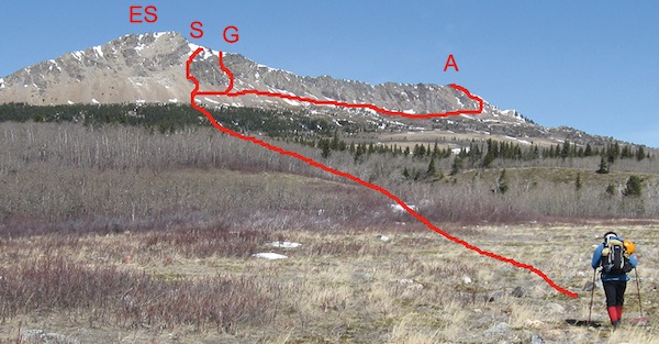
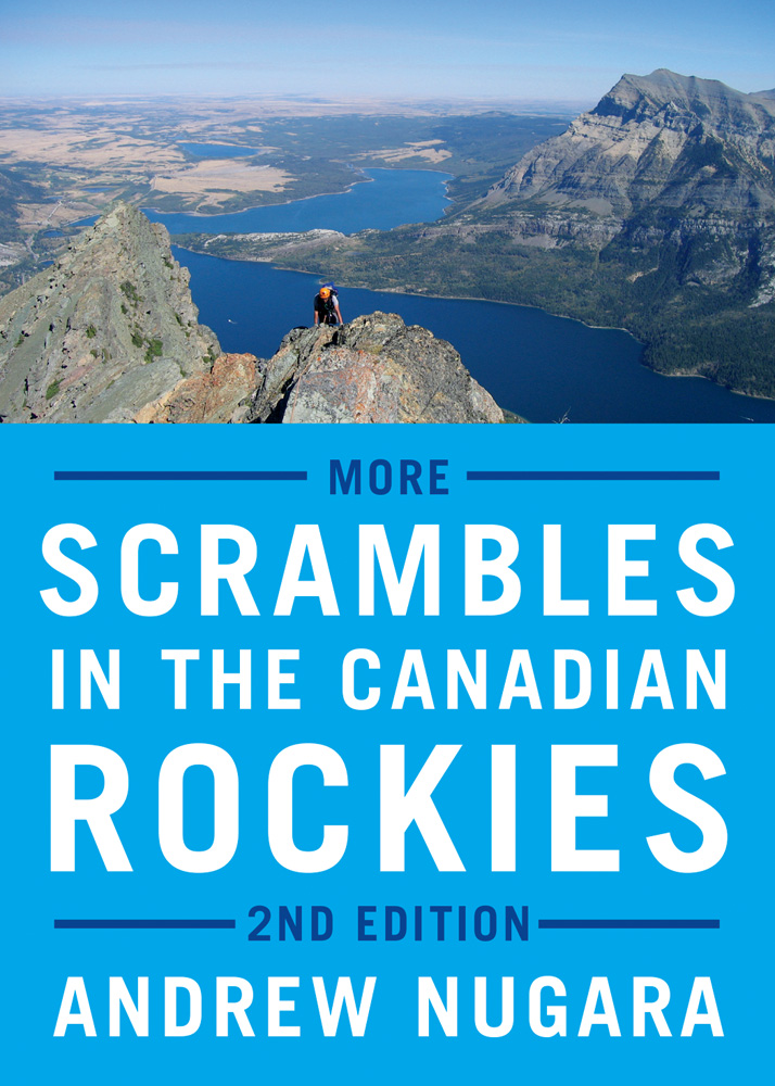
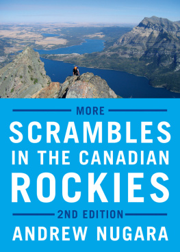
Mark Nugara embarks on the trek towards the east peak of the horseshoe-shaped ridge. The recommended ascent route is via the steep gully (G).The scree route (S) is a little easier. For those wanting to explore the colourful rock from below, the alternative route (A) is an option. ES = east summit of Lakeview Ridge
Font size:
Interval:
Bookmark:
Similar books «More Scrambles in the Canadian Rockies»
Look at similar books to More Scrambles in the Canadian Rockies. We have selected literature similar in name and meaning in the hope of providing readers with more options to find new, interesting, not yet read works.
Discussion, reviews of the book More Scrambles in the Canadian Rockies and just readers' own opinions. Leave your comments, write what you think about the work, its meaning or the main characters. Specify what exactly you liked and what you didn't like, and why you think so.