ACKNOWLEDGMENTS
All the facts in this book are based on at least one authorityoften the archives of the Los Angeles Times or the former weekly newspaper of The Palms and Culver City, called simply the Citizen. Sometimes the authority is that of the author himself, who witnessed many of the events at first hand during the past 50 years.
Simply put, the book could not have been completed without Marc Wanamaker and his Bison Archives. Jonathan Weiss of Cheviot Hills made available his collection of articles and his moral support. The archives of the Culver City Historical Society were helpful, as were Julie Lugo Cerras Culver City History and her fresh and vibrant Web site at www.culvercity.org . Joyce Cohen at Palms Elementary School opened a locked case to share old photographs.
Images are referenced as follows:
Bison from Marc Wanamaker;
HEC-LAPL from the Los Angeles Herald Examiner Collection of the Los Angeles Public Library;
SPC-LAPL from the Security Pacific Collection of the same library;
USC from the digital archives of the University of Southern California;
Spence from Spence Air Photos in the collection of the UCLA Department of Geography;
CCHS from the Culver City Historical Society;
MHL from the Margaret Herrick Library of the Motion Picture Academy of Arts and Sciences.
Pastor Charles Paul of the West Los Angeles Christian Center provided the striking image of the congregation on page 87. Then there were Phyllis Thomas of St. Mary in Palms Church, Sandi Dick at St. Johns Presbyterian Church, and Ruth Golby of the Culver-Palms United Methodist Church. Mel Gilliard, executive director of the First Lutheran Church since 1989, reminisced at length about the changes on his street from little frame houses to big apartment buildings and provided the image on the bottom of page 85.
Norman Tabor gave us the photograph of his family home on page 21 at top.
The Culver City Julian Dixon Library furnished copies of 1927, 1937, and 1949 city directories published by the Los Angeles City Planning Department. The Web site of the Los Angeles City Public Library was indispensable in tracing the history of our community.
The modern images not referenced were made by the author.
Finally, this book owes its thoroughness to the people in the special collections unit of Loyola Marymount University, where the volumes of the Citizen are so lovingly attended.
George Garrigues
www.ULWAF.com
Find more books like this at
www.imagesofamerica.com
Search for your hometown history, your old
stomping grounds, and even your favorite sports team.
One
WHERE IS PALMS?
Where is Palms? A hundred years ago, an Angelino might have responded, Halfway to Santa Monica on the Air Line or Halfway to the beach on the Venice Short Line.
Today the answer might be, Well, I used to live there! Its south of Beverly Hills and north of Culver City.
The truth is there are no defined boundaries. Palms has always been under somebody elses thumb: first the County of Los Angeles and then, after 1915, the City of Los Angeles.
In the fall of 1939, the Automobile Club of Southern California put up PALMS markers on Venice, Robertson, and Palms Boulevards, and other highways leading into the community, according to H. J. Ryan, president of the Palms Chamber of Commerce. There was not much else around. Palms was an important place. Palms was where everyone in the area shopped and went to the doctor, to church, and to the movies.
As the years passed, newer, outlying districts began to grow, where attractive, modern homes sprang up. Pico Boulevard was extended westward from Los Angeles and grew as a shopping strip. New schools and churches were established. Large swaths of old-time Palms were rezoned for apartments. Upmarket Westside Village, on the other hand, managed to hang on to its single-family, sidewalk-less, almost rural charm.
Where is Palms? This book defines Historic Palms in the context of its time: It is that area that at one time was considered to be Palms. Modern Palms is more of a state of mind: I know it when I see it. The maps in this chapter also help explain why some Angelinos are still asking Where is Palms?
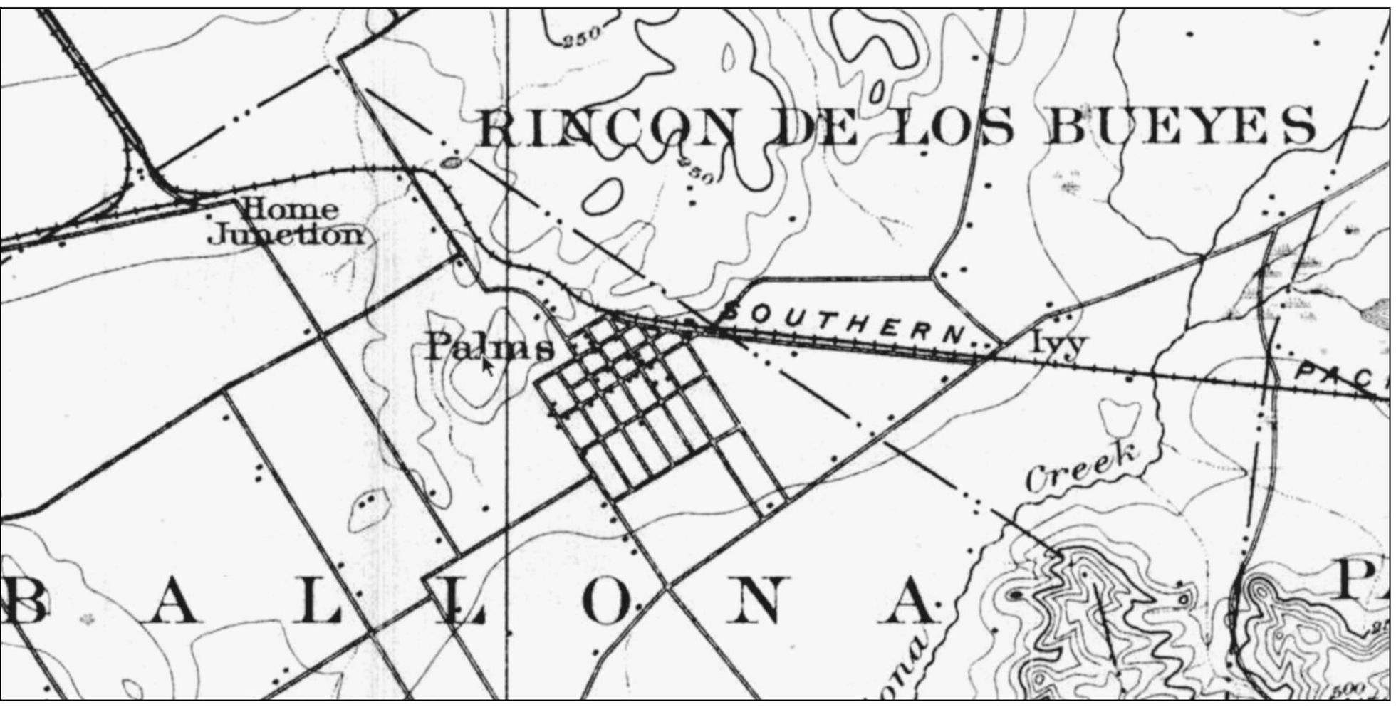
BUILDINGS AND A BIRTHDAY. This 1896 map demonstrates how the Palms tract was nestled south of the Southern Pacific rail line. Ten years after the settlements founding, each dot represents a building. The word Palms is spread over the hill that became Westside Village. Todays Cheviot Hills is north of the tracks. The dotted boundary between ranchos Rincon de los Bueyes to the northeast and La Ballona to the southwest is followed today by Manning Avenue and Faris Drive. Home Junction lies near where Sawtelle Avenue and Pico Boulevard now cross. Though Palms was founded as an alcohol-free community, in January 1896, Gaspar Valenzuela planned to open a saloon at the Ivy junction (outside the Palms tract). In September 1896, Palms Republicans organized a McKinley Club, Aunt B Wallace celebrated her 90th birthday with a big party, and Alice Frazier of Orange began teaching at Palms Grammar School.
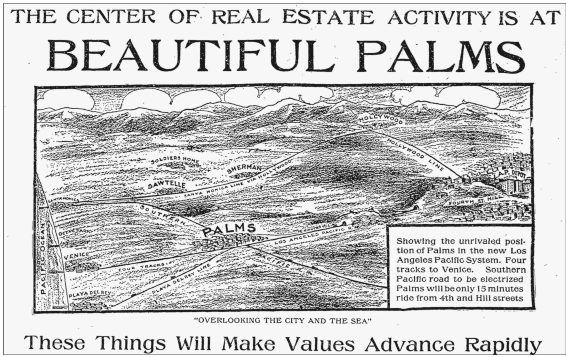
FEBRUARY 10, 1907. According to an advertisement of the Palms Land, Light, and Water Company at 309-310-311 Union Trust Building in Los Angeles, Street work is progressing rapidly; graders and cement workers are busy; two forces of surveyors are working from daylight till dark; estimates are being made for the new gas works and electric lighting plant, and contracts are being signed by future consumers.... Palms [will be] a city of beautiful homes and rapidly increasing population. Hundreds are buying lots for home and for investment. Nobody who sees Palms is disappointed in it. Reality far exceeds their most sanguine expectations. We own between 400 and 500 acres in Palms, including all the hilltops in and around the city. We offer the cream of business and residence lots.... We loan money to build to those who pay cash for their lots.... Free tickets at our office.
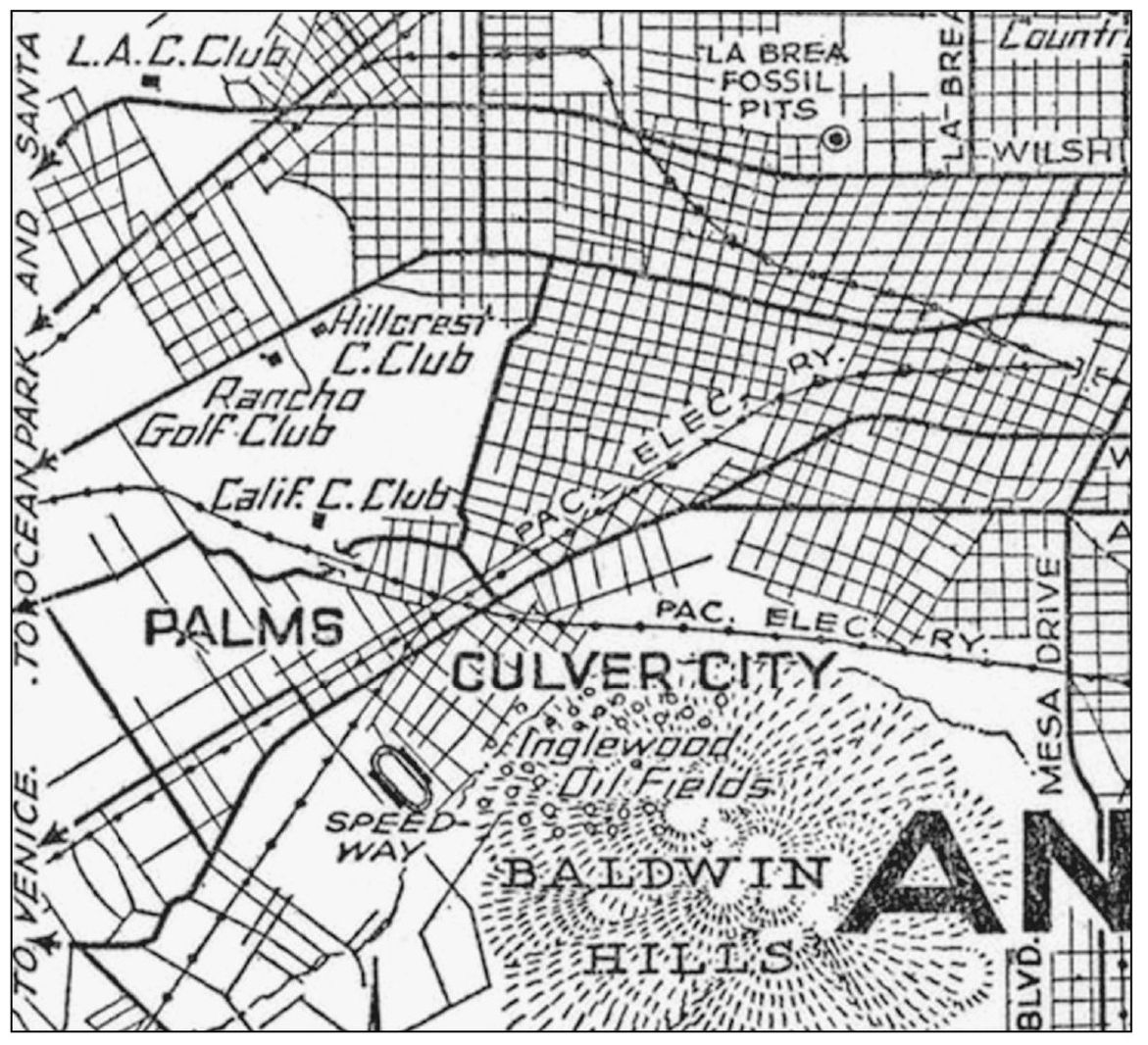
CITY MOVES WESTWARD. The grid pattern of West Los Angeles is particularly noticeable in this Automobile Club map from the 1920s. There was still no development in Cheviot Hills, Rancho Park, or Westside Village.
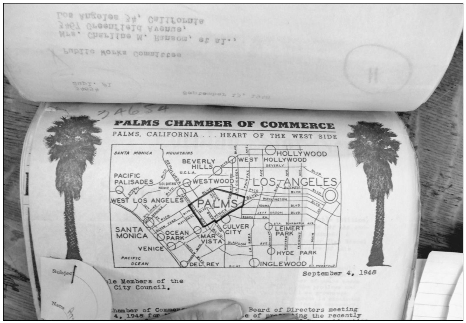
PALMS IN 1948. This letterhead from the city archives shows the area represented by the Palms Chamber of Commerce in 1948bounded by Pico Boulevard to the north, Manning Avenue to the northeast, Fairfax Boulevard to the east, Culver City to the south, and Sawtelle Boulevard to the west. The plea to the Los Angeles City Council sought the opening of a roadway through the Palms Junior High School campus (see page 79).

