Veronico - D-Day: The Air and Sea Invasion of Normandy in Photos
Here you can read online Veronico - D-Day: The Air and Sea Invasion of Normandy in Photos full text of the book (entire story) in english for free. Download pdf and epub, get meaning, cover and reviews about this ebook. year: 2019, publisher: Stackpole Books, genre: Non-fiction. Description of the work, (preface) as well as reviews are available. Best literature library LitArk.com created for fans of good reading and offers a wide selection of genres:
Romance novel
Science fiction
Adventure
Detective
Science
History
Home and family
Prose
Art
Politics
Computer
Non-fiction
Religion
Business
Children
Humor
Choose a favorite category and find really read worthwhile books. Enjoy immersion in the world of imagination, feel the emotions of the characters or learn something new for yourself, make an fascinating discovery.

- Book:D-Day: The Air and Sea Invasion of Normandy in Photos
- Author:
- Publisher:Stackpole Books
- Genre:
- Year:2019
- Rating:5 / 5
- Favourites:Add to favourites
- Your mark:
D-Day: The Air and Sea Invasion of Normandy in Photos: summary, description and annotation
We offer to read an annotation, description, summary or preface (depends on what the author of the book "D-Day: The Air and Sea Invasion of Normandy in Photos" wrote himself). If you haven't found the necessary information about the book — write in the comments, we will try to find it.
Veronico: author's other books
Who wrote D-Day: The Air and Sea Invasion of Normandy in Photos? Find out the surname, the name of the author of the book and a list of all author's works by series.


D-Day: The Air and Sea Invasion of Normandy in Photos — read online for free the complete book (whole text) full work
Below is the text of the book, divided by pages. System saving the place of the last page read, allows you to conveniently read the book "D-Day: The Air and Sea Invasion of Normandy in Photos" online for free, without having to search again every time where you left off. Put a bookmark, and you can go to the page where you finished reading at any time.
Font size:
Interval:
Bookmark:
Published by Stackpole Books
An imprint of The Rowman & Littlefield Publishing Group, Inc.
4501 Forbes Blvd., Ste. 200
Lanham, MD 20706
www.rowman.com
Distributed by NATIONAL BOOK NETWORK
(800) 462-6420
Copyright 2019 by Nicholas A. Veronico
All rights reserved. No part of this book may be reproduced in any form or by any electronic or mechanical means, including information storage and retrieval systems, without written permission from the publisher, except by a reviewer who may quote passages in a review.
British Library Cataloguing in Publication Information available
Library of Congress Cataloging-in-Publication Data available
ISBN 978-0-8117-3809-5 (hardcover)
ISBN 978-0-8117-6813-9 (e-book)
 The paper used in this publication meets the minimum requirements of American National Standard for Information SciencesPermanence of Paper for Printed
Library Materials, ANSI/NISO Z39.48-1992.
Printed in the United States of America
Operation Overlord: The D-Day Invasion of France
T he war in Europe had raged since the German invasion of Poland on September 1, 1939, and the United States joined the struggle against the Axis powers on December 7, 1941, when the Japanese attacked the American fleet at Pearl Harbor. During the years leading up to the Allies cross-Channel invasion of the European continent, millions of lives had been lost, and the Allies would accept nothing less than unconditional surrender from Germany and Japan. The third Axis nation, Italy, was invaded on July 9, 1943, and subsequently surrendered on September 8, 1943.
After months of preparation, planning, and stockpiling of men, ships, and weapons, the Allies were ready to assault the European continent. From January to May 1944, more than 589,000 men arrived in the United Kingdom in advance of the invasion. The Germans expected the Allies to come ashore at Calais on the French coast, as this is the narrowest point along the Strait of Dover between England and France, and had heavily reinforced the Atlantic seawall with a vast network of shore batteries, beach obstacles, and minefields.
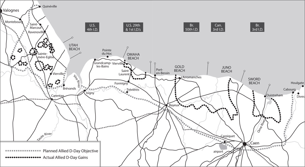
The Allies instead chose to invade the European continent along the Normandy region coastline in the Bay of the Seine, roughly between Le Havre in the north and Cherbourg on the Cotentin Peninsula in the south. After months of training soldiers in how to assault the beaches and sailors in how to handle landing craft and larger amphibious ships, a target date was set for Operation Neptunethe amphibious assault phase of Operation Overlord (the invasion of France).
Gen. Dwight D. Eisenhower was selected as Supreme Commander of the Allied Expeditionary Force. Managing the naval aspect of the invasion was Adm. Sir Bertram Ramsay (Royal Navy), who served as Supreme Naval Commander for the operation. Two men were responsible for getting the troops to the beaches: Rear Adm. Alan G. Kirk commanded the Western Naval Task Force, landing American troops on the beaches code-named Utah and Omaha; Rear Adm. Sir Philip Vian (Royal Navy) commanded the Eastern Naval Task Force that landed Commonwealth troops at Gold, Juno, and Sword Beaches.
Tides in the Bay of the Seine where the invasion would take place were very complex. When the tide rises from low to high water, the change in depth can be as much as 5 feet per hour, and the difference in area between high and low tide can cover more than 20 feet.
Allied naval forces had to know the tidal movements and ranges for each invasion beach. To obtain this data, predictions were made by the Intelligence Division, Office of the Chief Engineer, European Theater of Operations, US Army. The predictions were collated into estimated tide tables, which were then given to photo reconnaissance pilots who overflew the beaches recording the position of the tides and the times of the movements. The reconnaissance photos were then compared with the tidal estimates to provide an accurate picture of when the waterline would reach specific points on each of the assault beaches. The tidal timing developed by the Office of the Chief Engineer set the timescale for Operation Overlord. The majority of the images used to make the Overlord tidal maps were captured by the photo reconnaissance Spitfires (PR Mk XI) of No. 16 Squadron and the Mosquitos (PR Mk IX and XVI) of No. 140 Squadron, 34th Wing, Royal Air Force.
The tide tables also gave planners a good estimate as to when the German anti-invasion obstacles would be covered by the sea and to what depth, or when they would be exposed and easy for the landing craft to avoid. However, landing on the beach at low tide would expose the invading troops to greater fire from the defenders. Whatever path was chosen, men would be put into harms way.
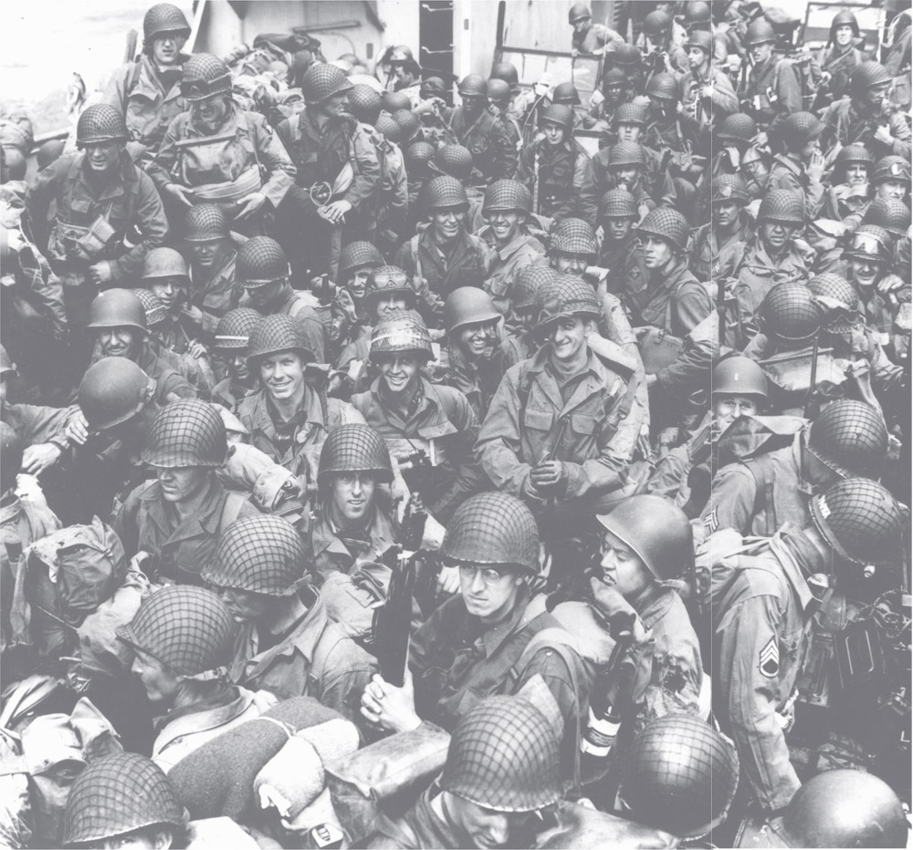
The invasion troops were boarded on ships at every dock, beach, and pier in southern England on May 28. US forces were supported by and transported in 931 ships, while the British and Commonwealth Armies sailed in 1,796 ships of all types. The invasion ships were ready on June 3, but the weather was not co-operating. June 4 was no better, and June 5 was predicted to be miserable too. Forecasters predicted a break in the weather on June 6, and close to midnight on June 4 General Eisenhower gave the invasion order: D-Day was set for the morning of June 6. The invasion armada sortied from the coast of England on the morning of June 5.
During the early- morning hours of June 6, more than 13,000 American and 8,500 British paratroopers landed behind the beaches. They were to capture vital bridges and secure beach exits to enable soldiers of the seaborne assault to move inland as quickly as possible. Offshore, at 2:00 a.m., minesweepers moved in, clearing channels for the fire support and amphibious ships that were soon to follow.
At 6:00 a.m., as ships of the invasion fleet approached the landing areas, German heavy coastal batteries opened up, firing at the approaching invasion fleet.
Facing the soldiers coming ashore were beach obstacles designed to snare landing craft, anti-ship mines, antipersonnel mines along the beaches and down to the tide line, one armored division, two mobile infantry divisions, and three additional divisions of vehicle-less infantry. Six armored divisions plus the German Fifteenth Army were within a days march of reinforcing the army at the beachhead.
Allied troops began reaching the beach at 6:30 a.m. to face withering fire from the German defenders. LCI-93 , LCI-553 , and LCT-612 were shelled by shore batteries and subsequently sank. The quiet weaponundersea minestook a heavy toll: Destroyer Corry (DD-463), anti-submarine patrol craft PC-1261, eleven tank landing craft, and five infantry landing craft were quickly sent to the bottom. Casualties from these ships were enormous, and those who survived had a long swim to the beach, if they could shed their full combat gear, or hoped for rescue by surrounding vessels. In spite of German resistance, both active and passive, more than 21,000 men and more than 1,700 tanks, half-tracks, trucks, and jeeps were ashore at Utah Beach by 6:00 p.m.
German casemated gun emplacements were the target of the day for Allied fire-support ships. Gun fire support was called for by Army units on the ground, and the fall of the shot was monitored by Navy pilots flying from land bases in Britain.
Next pageFont size:
Interval:
Bookmark:
Similar books «D-Day: The Air and Sea Invasion of Normandy in Photos»
Look at similar books to D-Day: The Air and Sea Invasion of Normandy in Photos. We have selected literature similar in name and meaning in the hope of providing readers with more options to find new, interesting, not yet read works.
Discussion, reviews of the book D-Day: The Air and Sea Invasion of Normandy in Photos and just readers' own opinions. Leave your comments, write what you think about the work, its meaning or the main characters. Specify what exactly you liked and what you didn't like, and why you think so.