Seal Beachs destiny was shaped in large part by its geographya remote highland isolated by two sprawling bays/wetlands and the flat, fertile soil (and subsequent agricultural success) of the Hellman and Bixby ranches. The former made access inconvenient and hindered the early success of Bay City and the Seal Beach amusement resort, and the latter allowed those owners to keep their lands undeveloped and intact, which later made the open space attractive for the Navy and then orderly large-scale development in the 1960s.
Published by The History Press
Charleston, SC 29403
www.historypress.net
Copyright 2014 by Larry Strawther
All rights reserved
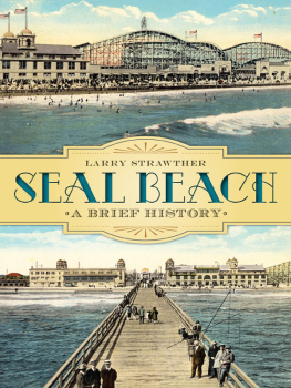
Front cover: Two postcards, circa 1916, show the Seal Beach Pavilion and Joy Zone Amusement Area, dominated by the Derby roller coaster. Postcards hand-colored from original photos by Edward Cochems.
First published 2014
e-book edition 2014
ISBN 978.1.62585.035.5
Library of Congress Cataloging-in-Publication Data
Strawther, Larry.
Seal Beach : a brief history / Larry Strawther.
pages cm
Includes bibliographical references and index.
print edition ISBN 978-1-62619-489-2 (paperback)
1. Seal Beach (Calif.)--History. 2. Seal Beach (Calif.)--Social conditions. 3. Seal Beach (Calif.)--Social life and customs. 4. Social change--California--Seal Beach--History. 5. Seal Beach (Calif.)--Biography. I. Title.
F869.S593S77 2014
979.496--dc23
2014010143
Notice: The information in this book is true and complete to the best of our knowledge. It is offered without guarantee on the part of the author or The History Press. The author and The History Press disclaim all liability in connection with the use of this book.
All rights reserved. No part of this book may be reproduced or transmitted in any form whatsoever without prior written permission from the publisher except in the case of brief quotations embodied in critical articles and reviews.
CONTENTS
ACKNOWLEDGEMENTS
Many people have been very helpful and gracious during the research and writing of this book. My thanks to Chris Jepsen at the Orange County Archives, Charles and Marie Antos at the Seal Beach Cultural and Historical Society, Carrie Reed at the Orange County Library, Mary Wilson branch library in Seal Beach and Laura Alioto, Libby Appelgate and Michael Dobkins for sharing their vast memories of Seal Beach events.
And of course, thanks to my wife, Nancy, who is still trying to figure out why my office has to be so messy and cluttered while doing research.
INTRODUCTION
Many people know far more about Seal Beach than me. Unfortunately, with a few exceptions, those people havent written books. And because I wanted to know more about the townearly Anaheim Landing, Phil Stanton, the red cars, Joy Zone, rumrunners, gambling ships, summers on the bay, the early days of surfing and the people who used to live hereI started doing some research here, more research there until I realized that even considering what I dont know, I still have a lot of good information worthy of a book. So here it is.
Unlike earlier city historians, I had the advantage of the Internet, which has provided access to a treasure-trove of information heretofore buried in college libraries around the country. Ive incorporated much of that information in here.
Seal Beach was originally a city of hypea real estate development where honesty and factual history took a back seat to hoopla and press releases that have been passed down as fact over the yearsand over beers.
Like the issue of whether John Ord was Seal Beachs first resident. He wasnt.
Nor was the towns original name of Bay City changed because of confusion with San Francisco, and the Seal Beach amusement area (the Joy Zone) was not one of Southern Californias most popular tourist areas until the Depression did it in. The Joy Zone, overwhelmed by competition from other beach cities, was a financial disappointment right from its start in 1916 and was basically out of business by 1925.
But not to worrymost of the legends are based in truth, and newly discovered facts are more impressive than the previous hype.
There is probably too much information in this book. But since the town has never had a thorough history written about it, I figured I had better cram all the info in now. Who knows how long before the next one is written?
I stop my story of Seal Beach in 1967 for what I think are extremely good reasons:
First, I didnt want to write a five-hundred-page book.
Second, by avoiding the craziness of the 1970s and 80s, I can keep friends.
Finally, 1967 was arguably the year that Seal Beach stopped being an isolated small town. Some say that happened when Leisure World opened in 1962. Or when the school districts merged in the early 1980s. But to me it was 1967after the annexation of the Rossmoor Business Center, when the separation between Seal Beach and its neighbors to the north became seamless.
Im sure Ive left out deserving events and memorable characters. The more I learned, the more I realized how little I still knew about the town. But hopefully, Ive also brought much forward that has been overlooked and given a good account of why Seal Beach is what it is.
So I hope you Old Town old-timers are willing to cut this inlander some slack. But if you arent, then go down to Main Street, and while having a beer, start your own book or article. I look forward to reading it.
CHAPTER 1
THE BASICS
Except for Landing Hill, all seventy feet of it, Seal Beach is flat. From an elevation of thirty-eight feet in easternmost College Park East, it drops over two miles to twelve feet by the high tide line of the wetlands and local beaches. Before the straightening of the San Gabriel River and construction of the levees, this area frequently flooded when heavy rains carried water from the San Gabriel and San Bernardino mountains.
Pacific storms often stalled over these mountains, sometimes releasing incredibly heavy precipitationa 1943 storm dumped twenty-six inches on Hoegees Camp in a twenty-four-hour period. Annual rainfall near the coast averaged twelve inches, but in the mountains, it exceeded forty inches per year (more than Portland and Seattle). As the mountain soils saturated, debris of boulders, gravel, sand and silt fell into canyon streams and was carried along on its journey toward the ocean.
Most of the water sank into the sand and gravel soil of the San Gabriel Valley, the Inland Empire and Los Angeles basin. In some places, the gravel was six miles deep. Gravity induced most of the run-off water to sink into the large aquifersunderground reservoirs that slowly made their way through the slanted layers of sediment that descend to the ocean.
On reaching the main Los Angeles basin, the waters would sometimes spread out or form and reform channels on a whim. The San Gabriel River sometimes sent its water west to merge with the Los Angeles River, sometimes east to join up with Coyote Creek, sometimes south directly into Alamitos Bay. Farther east, the Santa Ana emptied at times into Bolsa Chica or Anaheim Bay until the floods of 1862 diverted it permanently to empty near Newport Bay. During great rainfalls, the floodwaters spread out and joined up in one vast sheet of water fifteen miles wide, allowing individuals to travel by canoe from Long Beach to Newport. The floods led the U.S. Army Corps of Engineers to consider these rivers, especially the Santa Ana, as the greatest flood threats in the nation.
Next page
