IDAHO NOTEBOOK
Dennis Sonius
The sixth edition of the Idaho Notebook is available only in electronicformat.
This edition is completely revised and aligned withthe Idaho Content Standards
Grade 4 Social Studies.
Dennis Sonius, Publisher
Twin Falls, Idaho
First Edition 1977
Smashwords Edition
Copyright 2014 Dennis Sonius
All Rights Reserved
TABLE OF CONTENTS
Where in the U.S.A ?
i
WHERE IN THE U.S.A.?
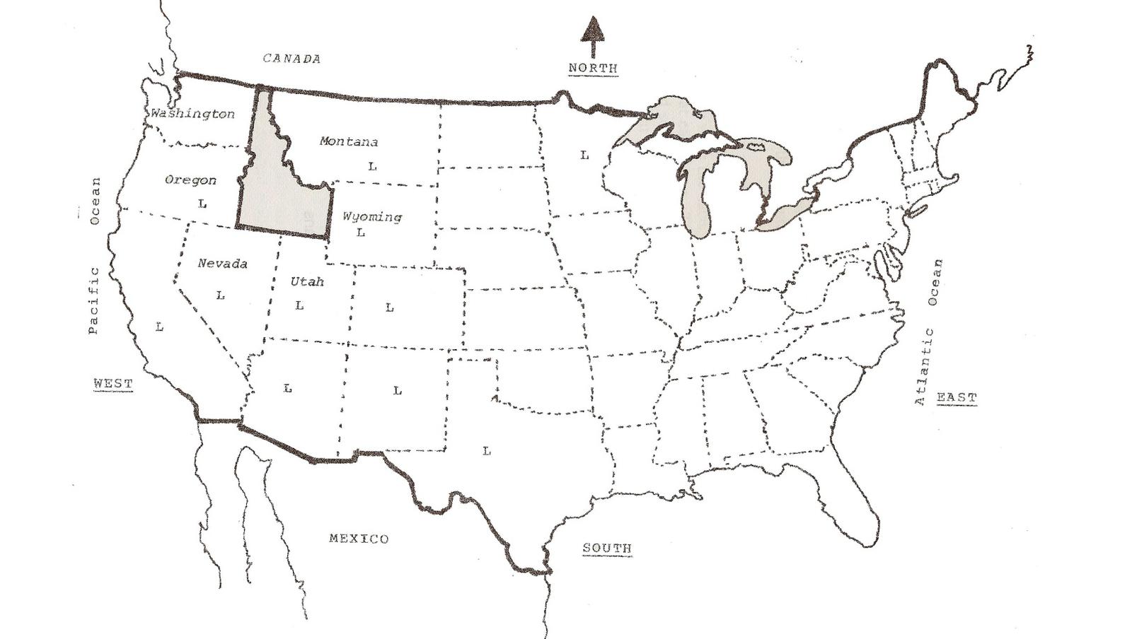
North of Idaho is Canada. Canada is a country asis the United States. Idaho also shares its borders with sixstates. Can you name them?
Is Idaho wider near the border on the north orthe border on the south?
Is Idaho closer to the Pacific Ocean or theAtlantic Ocean?
Is Idaho more in the north or the south of theUnited States?
Alaska and Hawaii are not on this map. The otherstates are shown with dotted borders. The states larger than Idahoare shown with an L. Do you think Idaho is a large state or asmall state?
Twelve states are larger than Idaho.Thirty-seven states are not as large as Idaho. Idaho is larger thanthe nine smallest states added together. The top part of Idaho iscalled a panhandle. Idaho is 44 miles wide at the panhandle. Idahois 303 miles wide at the southern border. It is 483 miles fromCanada to Nevada.
Idaho Content Standard 2: Geography Goal 2.1Obj.4.SS.2.1.1. Lexile 640
Idaho is a land of up and down. It has thedeepest canyons in North America. Idaho has mountain peaks over12,000 feet high. Idaho has rolling hills and meadows. More than2,000 lakes dot Idaho. Several important rivers carry water fromIdahos mountains toward the Pacific Ocean.
Scientists believe millions and millions ofyears were needed to make Idaho look like it does today. Vast seascovered the land again and again. Volcanoes erupted. Huge areas ofland settled or pushed upward forming mountains.
A huge sea covered Idaho millions of years ago.Soil, sand and gravel washed into the sea from higher lands. Thegold, silver and other minerals found in northern Idaho were washedinto the sea. The heat and pressure within the earth caused thegold and silver to melt. It ran together forming veins. Later, thesea bottom pushed upward and formed mountains. The solid mountainrocks held the gold and silver veins.
The mountains of central Idaho pushed upwardhundreds of millions of years ago. Glaciers filled many mountainvalleys. A large glacier covered Idahos panhandle. The glaciersspread the gold nuggets and other minerals. Glaciers caused many ofour lakes and valleys. Wind and water have worn the mountains tohelp them look as they do today.
Seven times seas filled and drained southernIdaho over 450 million years. The ground moved or shifted upwardand downward causing the seas to empty and cut great valleys. Thelast great sea left Idaho 150 million years ago.
The earths crust rests on several plates. Onehundred and fifty million years ago the plate holding North Americarubbed the Pacific Ocean plate. The pressure caused layers of rockto move upward. This created many of our mountains including theRocky Mountains which cover much of Idaho.
Volcanoes began erupting about two million yearsago. Lava flowed into the valley covering southern Idaho. The lavain the Snake River valley became one mile deep in places. The lastof the lava flows happened less than 1,000 years ago. That lava canbe seen at the Craters of the Moon National Monument.
Less than one million years ago, Lake Bonnevilleoverflowed its shores where the Utah-Idaho border is today. Thelake water rushed over southern Idaho for weeks. The water movedsoil and rocks. It changed the way the land along the Snake Riverlooks.
Scientists believe Idaho was formed by theaction of the seas, land shifts, volcanoes and weather. Sea shellsand other fossils found on the mountain peaks show us the mountainswere once the floor of a sea.
The land in Idaho is still changing. Wind, rain,frost, fire and sunshine cause the soil to wear away. Farming,mining, logging and dams have changed the land. Idaho may have adifferent appearance many years from now.
1. What state has the deepest canyon in NorthAmerica?
2. What caused many of the lakes and valleys inIdahos panhandle?
3. How many times was Idaho cover by a sea?
4. How deep did the lava flows in southern Idahobecome?
5. Where can you still see the last lava flowsin Idaho?
6. What lake flooded Idaho nearly one millionyears ago?
7. How high are Idahos tallest mountainpeaks?
8. What can we find on mountain peaks that wereonce on the sea floor?
9. Look at a map of Idaho. Locate the followingfeatures:
A. Two large lakes in Idahos panhandle.
B. Craters of the Moon National Monument.
C. Mount Borah, Idahos tallest peak.
D. The Snake River.
E. Find the Salmon River. See how it winds as it flows betweenthe mountains.
Idaho Content Standard 2: Geography Goal 2.1Obj. 4.SS.2.1.1. Lexile 780
Idaho has over 16,000 miles of rivers. Most of the water inthose rivers drains to the west where it joins the Columbia Riverand flows to the Pacific Ocean. Five river systems cross Idahotaking water from the mountains in the eastern part of Idaho to thewest.
The Snake River starts in Wyoming, crosses Idaho and flows intothe Columbia River in Washington. It is 1,036 miles long. The SnakeRiver has many tributaries. Tributaries are rivers or streams thatflow into larger rivers.
The Snake River provides water for farms in southern Idaho. Rainand melting snow in the mountains flow into the rivers. The SnakeRiver and its tributaries have many dams that store water untilfarmers need it. Without the dams, the water would leave Idaho andgo to the Pacific Ocean. The farms would be desert land without thewater from the Snake River system. Without the farms, there wouldnot be any towns or cities along the Snake River.
The dams on the Snake River also make electricity. The SnakeRiver is the largest maker of electricity in Idaho.
The Salmon River is the longest river in the United States tobegin and end all in one state. The Salmon River is 420 miles long.It rushes through canyons and mountain valleys on its way to jointhe Snake River. It is important for fishing and recreation. It isnot used much for creating electricity or watering farmland.
The Clearwater River also begins and ends in Idaho. It is not aslong as the Salmon River. But, it carries more water to the SnakeRiver than the Salmon River carries. The Clearwater River makessome electricity. It is used mostly for boating, fishing andrecreation. For many years, it was a working river. Loggers usedthe river to float the logs to sawmills.
The St. Joe, St. Maries and Coeur dAlene rivers flow into CoeurdAlene Lake. The Spokane River is the outlet. It flows to theColumbia River in Washington. This river system was once used fortravel. Now the rivers are used mostly for recreation.
The Pend Orielle River is the outlet for Lake Pend Orielle. Onlythe Snake River carries more water than the Pend Orielle River inIdaho.
The Kootenai River crosses the panhandle and flows into Canadawhere it also joins the Columbia River. It begins in Montana. Themain use of the Kootenai River is recreation.
The Bear River is the only Idaho river not draining toward thePacific Ocean. It starts in Utah, flows through the corners ofWyoming and Idaho and returns to Utah. The water from the BearRiver flows into the Great Salt Lake in Utah. The water from theBear River is heavily used for farming and creatingelectricity.

