Published by The History Press
Charleston, SC 29403
www.historypress.net
Copyright 2009 by Joe A. Mobley
All rights reserved
All images courtesy of North Carolina Office of Archives and History, Raleigh, unless
otherwise noted.
First published 2009
e-book edition 2012
ISBN 978.1.61423.296.4
Library of Congress Cataloging-in-Publication Data
Mobley, Joe A.
Raleigh, North Carolina : a brief history / Joe A. Mobley.
p. cm.
Includes bibliographical references and index.
print edition ISBN 978-1-59629-638-1
1. Raleigh (N.C.)--History. 2. Raleigh (N.C.)--History--Pictorial works. I. Title.
F264.R1M63 2009
975.655--dc22
2009044451
Notice: The information in this book is true and complete to the best of our knowledge. It is offered without guarantee on the part of the author or The History Press. The author and The History Press disclaim all liability in connection with the
use of this book.
All rights reserved. No part of this book may be reproduced or transmitted in any form whatsoever without prior written permission from the publisher except in the case of
brief quotations embodied in critical articles and reviews.
For Kay
CONTENTS
ACKNOWLEDGMENTS
I wish to express my appreciation to several individuals for their assistance in the completion of this volume. Many thanks go to Paulette Mitchell for a number of photographs that illustrate the book. I am also grateful to Elizabeth Crowder, who searched for historical images of Raleigh, and to Kim Cumber of the North Carolina State Archives, Office of Archives and History, for copies of photographs from the Archives files. I owe a note of thanks to Jennifer Litzelman of the Raleigh City Museum and to my mentor and friend William C. Harris for their interest and advice. Gratitude is due Jackie Savage and RBC for their assistance in making aerial photographs of downtown Raleigh. My greatest debt is to my wife, Kathleen B. (Kay) Wyche, who proofread and corrected the draft. Her encouragement, advice, and editorial skill were indispensable to this book.
INTRODUCTION
A TOWN AT THE CROSSROADS
In the aftermath of the American Revolution, the time had come for North Carolina to establish a permanent state capital. But where should it be located? Since the war, the government of North Carolina had been a vagabond institution, moving from town to town. Even before the Revolutionuntil royal governor William Tryon built the imposing Governors Palace at New Bern in 1770colonial North Carolina had no fixed location at which the governor and the assembly could meet to conduct the official business of the colony. From year to year, the legislature convened at different sites, holding its sessions in various buildings, including churches and private residences. Governors and other officials conducted day-to-day business from their own homes. In the decade following the Revolutionary War, the legislature convened at Hillsborough, Fayetteville, New Bern, and Tarboro.
North Carolinas lawmakers recognized the necessity for establishing a permanent capital but could not reach a consensus on where to plant it. They ruled out New Bern, which was not centrally located and possibly subject to invasion from the coast. Fayetteville, Hillsborough, and Tarboro continued to vie strongly for the privilege and benefits of hosting the state capital. Politics and sectionalism prevailed as legislators favored sites in their areas. In 1782, Hillsborough was selected as a temporary location, but that authorization was repealed the following year. The heated debate continued, as none of the three towns could secure enough votes to defeat the other two.
In exasperation, the legislature assigned the task of selecting a site to a convention meeting in Hillsborough in the summer of 1788 to vote for or against ratification of the U.S. Constitution. (The Hillsborough convention voted against ratification, but a second convention in Fayetteville in 1789 ratified the document.) A committee appointed by the Hillsborough convention called for an unalterable seat of government of this state to be created within ten miles of Isaac Hunters tavern on his plantation in Wake County. Hunter reportedly served a potent rum punch that was a favorite with legislators.
But the committee left the choice of the exact site to the legislature. The debate among the legislators then continued. Some argued that a capital at the Wake County location would never become larger than a mere village. Advocates for Fayetteville persisted in a strong argument for that town. Some eastern inhabitants complained that Wake County was too far west, and folk in the west argued that it was too far east. Not until 1791 did the Wake County site receive enough support for its selection as a permanent seat for state government. The General Assembly appointed a commission to acquire land for the new capital. The commissioners visited several farms and plantations but continued to put off a decision.
Among the promising tracts that they visited was the large plantation of Joel Lane, the legislator who introduced the bill to establish Wake County in 1771. He also served as a commissioner to set the boundaries of the county and to establish the initial county seat, known as Wake Courthouse, at a site previously called Wake Crossroads. The first county court session met at Lanes residence in 1771, and the legislature convened there during the Revolution and again in 1781. Wake Courthouse (also called Bloomsbury for a short while) lay in the center of the county and at the crossing of two main roads. One ran from the coast westward toward Hillsborough; the other ran south from Virginia to South Carolina. When erected, the original courthousebelieved to have been a log structurestood a short distance from Lanes house. A close rival to Lanes site was a nearby tract owned by Colonel Robert Hinton and located on the banks of the Neuse River, which some commissioners thought would provide a good trade route by water to the coast. Ultimately, however, Lane wined and dined the legislative commissioners at a sumptuous dinner. Shortly thereafter, they recommended the purchase of a portion of his land for the permanent seat of state government. In early April 1792, the State of North Carolina bought one thousand acres from Lane for 1,378 ($2,756).
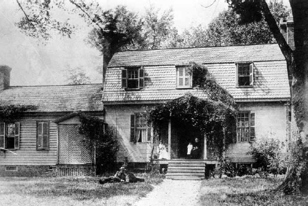
Joel Lane House. Lane sold North Carolina the land on which to establish Raleigh.
The legislature had commissioned William Christmasa state senator, militia commander, and surveyorto survey the land and lay out a town. According to his plan, the town covered four hundred acres of the one thousand purchased from Lane and was bordered by North, South, East, and West Streets. In the center of the tract stood Union (now Capitol) Square, where the capitol building (called the State House) would be constructed. Equidistant from Union Square were four additional squares of four acres each. Those squares subsequently bore the surnames of four Revolutionary leaders and state politicians: Thomas Burke, Richard Caswell, Alfred Moore, and Abner Nash. The commissioners named the streets bordering Union Square after North Carolinas eight court districts: Edenton, Fayetteville, Halifax, Hillsborough, Morgan, New Bern, Salisbury, and Wilmington. Nine other streets were named after the commissioners themselves: James Bloodworth, Thomas Blount, William J. Dawson, Frederick Hargett, Henry William Harrington, Willie Jones, James Martin, Joseph McDowell, and Thomas Person. The names of the remaining four streets honored other prominent North Carolinians: Stephen Cabarrus, William R. Davie, William Lenoir, and the original owner of the land, Joel Lane. The plan stipulated that the four streetsFayetteville, Halifax, Hillsborough, and New Bernleading directly to Union Square would measure ninety-nine feet wide. The remaining streets would have a width of sixty-six feet. Workers began clearing the land of trees and underbrush for the squares and streets. But many years would pass before any paving of thoroughfares occurred. Wet weather left them muddy, and ruts and dust were constant obstacles and annoyances for vehicles and pedestrians.
Next page
