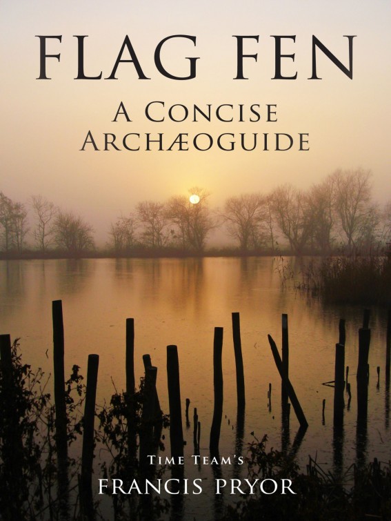
Pryor - Flag Fen: A Concise Archæoguide
Here you can read online Pryor - Flag Fen: A Concise Archæoguide full text of the book (entire story) in english for free. Download pdf and epub, get meaning, cover and reviews about this ebook. publisher: Francis Pryor, genre: Religion. Description of the work, (preface) as well as reviews are available. Best literature library LitArk.com created for fans of good reading and offers a wide selection of genres:
Romance novel
Science fiction
Adventure
Detective
Science
History
Home and family
Prose
Art
Politics
Computer
Non-fiction
Religion
Business
Children
Humor
Choose a favorite category and find really read worthwhile books. Enjoy immersion in the world of imagination, feel the emotions of the characters or learn something new for yourself, make an fascinating discovery.
Flag Fen: A Concise Archæoguide: summary, description and annotation
We offer to read an annotation, description, summary or preface (depends on what the author of the book "Flag Fen: A Concise Archæoguide" wrote himself). If you haven't found the necessary information about the book — write in the comments, we will try to find it.
Pryor: author's other books
Who wrote Flag Fen: A Concise Archæoguide? Find out the surname, the name of the author of the book and a list of all author's works by series.


Flag Fen: A Concise Archæoguide — read online for free the complete book (whole text) full work
Below is the text of the book, divided by pages. System saving the place of the last page read, allows you to conveniently read the book "Flag Fen: A Concise Archæoguide" online for free, without having to search again every time where you left off. Put a bookmark, and you can go to the page where you finished reading at any time.
Font size:
Interval:
Bookmark:
Published by BoudiccaBooks, 2014.
Copyright
Cover photographreproduced by kind courtesy of Vivacity.
First published inGreat Britain by High-Res History in 2012.
This edition publishedJuly 2014 at Smashwords by Boudicca Books.
Francis Pryor assertsthe moral right to be identified as the author of this work.
Copyright Francis Pryor2012.
This edition copyrightFrancis Pryor. 2014
Smashwords Edition,License Notes
This ebook is licensedfor your personal enjoyment only. This ebook may not be re-sold orgiven away to other people. If you would like to share this bookwith another person, please purchase an additional copy for eachrecipient. If youre reading this book and did not purchase it, orit was not purchased for your use only, then please return to yourfavorite ebook retailer and purchase your own copy. Thank you forrespecting the hard work of this author.
CONTENTS
1. The Fens in a Nutshell
Usually thiswas in winter and spring. Flag Fen was a bay of low-lying,waterlogged land immediately south-east of Peterborough. To theeast and west the land gradually rises and becomes flood-free. Thedry land to the east of the wet Flag Fen basin is known as Fengate,that to the west as Northey. Fengate lies at the edge of what onemight think of as mainland England; Northey is part of a largeisland in the Fens, which includes the market town ofWhittlesey.
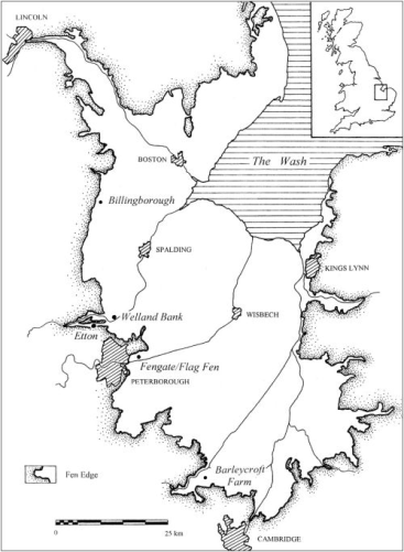
2. Background: The Landscape of Flag Fen
Thearchaeological site known today as Flag Fen was completely unknownbefore its discovery in November 1982. Before that it had lainconcealed beneath almost two metres of peat and river-borne floodclay, known as alluvium, which started to cover it up sometime inthe later Iron Age, over 2000 years ago. But the discovery did nothappen by chance. Like many archaeological finds, this one came tolight as the culmination of many years of patient and painstakingresearch.
The story beganin 1970 when I happened to read in an archaeological magazine thatPeterborough New Town was to be extended eastwards to cover theknown archaeological site of Fengate. At the time I worked for theRoyal Ontario Museum, in Toronto, Canada, and I was in Englandtrying to find a suitable site for a future series of excavations.And Fengate looked very promising indeed. So I returned toPeterborough the following year with a small team of Canadianstudents and recruited an equal number from various Britishuniversities. That first season revealed what we now know to havebeen one of Britains earliest Bronze Age field systems and theresults were so good that our Canadian sponsors, together with theold Inspectorate of Ancient Monuments at what was to become theDepartment of the Environment (the forerunner of English Heritage),decided to back us for the next few years. By the end of theproject, in 1979 we had revealed a remarkable story.
The firstfarmers arrived in the area sometime around 4000BC and clearance oftrees and woodland from the landscape was well under way by 3000BC.That was when a series of Neolithic shrines and other features,which may have been arranged along an ancient route way wereconstructed. These finds included a rather tragic grave which heldthe bodies of a man and a woman and (possibly their) two children.The man had been killed by a flint arrowhead which we found lodgedbetween his eighth and ninth ribs. That burial is on display inPeterborough Museum. Some five centuries later, around 2500BC, atthe start of the Bronze Age, the earlier farmed landscape wascarefully divided-up into one of the first field systems inBritain. The fields were marked-out by ditches, banks and hedgesand were laid out at right angles to the developing wetland. Theywere subdivided into blocks of land that were separated bydouble-ditched droveways (for livestock), which ran down to thewetland edge. These fields too were intended for the use ofanimals, mostly cattle and sheep. The farmers themselves lived insmall, isolated single farmsteads dispersed through the fields.Much later, excavations in the 1990s and early 2000s revealed thatthere were closely similar landscapes of ditched fields furtheralong the fen-edge towards the village of Eye and on the other sideof the Flag Fen basin, on the edge of Whittlesey island, atNorthey.
3. The Discovery of Flag Fen
The followingsummer we carried out an auger survey to determine how far thetimbers extended back from the dyke. It was hard work, as in thosedays machine-powered augers were rare, so Dr. Charles French andmyself did the drilling by hand. In the end we proved that timbercovered an area of about 150 by 150m arranged in a squashed oval.To our surprise, the dyke had only cut through a small part of theplatform. We called it a platform, because no other explanationseemed to make sense. Even today we are far from certain about itsoriginal purposes.
The next bigevent in the discovery of Flag Fen took place in the summer of 1989when the gas-fired power station, that still dominates the site tothe east, was built. As part of their work the contractors fundedan excavation which we carried out. Many people, some even in thearchaeological world, thought it unnecessary as the constructionwas to take place some 800m east of the dyke where seven yearsearlier we had revealed the timbers. But we insisted, and to theirgreat credit (and I wonder whether this would happen today?) thepower station builders insisted that our work should go ahead - andthey contributed generously towards it, too. It was a very hot, drysummer and hardly the best weather to dig waterlogged timbers, butat the end of it all we had discovered the Fengate landfall of atimber causeway which we could now trace right across Flag Fen fromthose posts we had found back in 82 on the platform, in thedykeside.
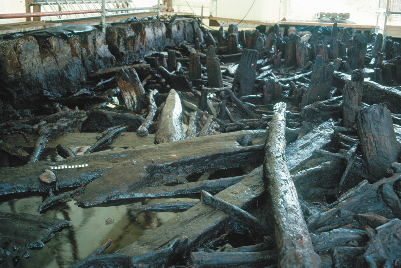
The highest level oftimbers to one side of the post alignment
We had beencarrying out detailed excavations around the posts in the dykesidebecause these were the most threatened by drying-out and in thecourse of that work we had found a handful of finds: a few scrappypieces of pottery, the odd flint, a bone or two but that was all.These were sufficient to tell us that the timbers indeed dated tothe later Bronze Age again, that was all. But the power stationsite changed everything. A detailed metal-detector survey, whichwas carried out in partnership with a local detectorists club,revealed just short of 300 metal objects, the vast majority ofwhich were Bronze Age. Almost everything from the Bronze Agemetal-workers repertoire was there: swords, daggers, rapiers,spearheads, brooches, bracelets, pins, axes, chisels, awls. And thedate range was quite clear too: roughly 1300 to 900BC, with a fewfinds dating to the Iron Age and even into Roman times. These dateswere subsequently confirmed by tree-ring studies.
4. The Post Alignment
We knew fromour work in the 70s and 80s that the dry land on either side ofthe wetter, lower lying parts Flag Fen basin had been settled andfarmed from at least 3000BC, when most of the natural tree coverhad also been removed. The lowest areas began to flood shortlyafter that date, as a result of the warmer climate, and rising sealevels, that followed the end of the last ice age, some tenthousand years ago. It seems highly probable that the early BronzeAge inhabitants of the area had already laid-out a route across thelowest land (which would probably have represented a flood hazardin times of heavy rainfall) even if the larger Fens had yet tostart forming. Rainwater will always pond in flat, low-lying land,especially if the natural drainage is not too good. We found veryslight evidence for such a route when we had removed the last ofthe posts at the power station site, in 1989. It consisted of ashallow ditch that more-or-less followed the line of the laterposts.
Font size:
Interval:
Bookmark:
Similar books «Flag Fen: A Concise Archæoguide»
Look at similar books to Flag Fen: A Concise Archæoguide. We have selected literature similar in name and meaning in the hope of providing readers with more options to find new, interesting, not yet read works.
Discussion, reviews of the book Flag Fen: A Concise Archæoguide and just readers' own opinions. Leave your comments, write what you think about the work, its meaning or the main characters. Specify what exactly you liked and what you didn't like, and why you think so.