Illustrations
Figures
2.4b Diagrammatic layout showing the possible distribution of lateral canals and their associated irrigated land versus a single longitudinal canal
10.1 Vase from Uruk
16.9 Modern impression of a cylinder seal showing the priest-king offering vegetation to sheep with a pair of Inanna gate posts
27.4 Plan of City II
Tables
0.1 Chronological framework for fourth millennium southern Mesopotamia
Maps
First published 2013
by Routledge
2 Park Square, Milton Park, Abingdon, Oxon OX14 4RN
Simultaneously published in the USA and Canada
by Routledge
711 Third Avenue, New York, NY 10017
Routledge is an imprint of the Taylor & Francis Group, an informa business
2013 Harriet Crawford for selection and editorial matter; individual contributions, the contributors.
The right of Harriet Crawford to be identified as the author of the editorial material, and of the authors for their individual chapters, has been asserted in accordance with sections 77 and 78 of the Copyright, Designs and Patents Act 1988.
All rights reserved. No part of this book may be reprinted or reproduced or utilised in any form or by any electronic, mechanical, or other means, now known or hereafter invented, including photocopying and recording, or in any information storage or retrieval system, without permission in writing from the publishers.
Trademark notice: Product or corporate names may be trademarks or registered trademarks, and are used only for identification and explanation without intent to infringe.
British Library Cataloguing in Publication Data
A catalogue record for this book is available from the British Library
Library of Congress Cataloging in Publication Data
A catalog record for this book has been requested
ISBN: 978-0-415-56967-5 (hbk)
ISBN: 978-0-203-09660-4 (ebk)
Typeset in Adobe Garamond
by Keystroke, Station Road, Codsall, Wolverhampton
Part I
The Background
Chapter Twenty-Five
Cultural Developments in Western Syria and the Middle Euphrates Valley During the Third Millennium BC
Lisa Cooper
Introduction
There is little doubt that the Sumerians of southern Mesopotamia were in contact with the people who inhabited the areas of western Syria and the middle Euphrates River Valley during much of the third millennium BC. This contact, which involved cultural and economic exchanges, is documented in Syria by extant textual records as well as archaeological remains which bear the unmistakable imprint of Sumerian civilisation. It would be erroneous, however, to attribute all important cultural developments in Syria to its Sumerian neighbours. The evidence indicates that the regions of western Syria and the middle Euphrates River Valley underwent important transformations in socialcultural complexity and advances towards urbanism in ways that uniquely diverged from other parts of the Near East, including southern Mesopotamia. This chapter describes what is known about western Syria and the middle Euphrates River Valley during the third millennium BC, emphasising the regions unique geographical features, and highlighting the local ideological, social and political traditions that seem to account for much of the areas distinctive cultural character and developments during this time period.
Geography and Subsistence
The regions of focus here comprise several areas of varying size, environment and topography (SyrianTurkish border at Carchemish down to the confluence of the Balikh and the Euphrates just below the site of Tell Bia (ancient Tuttul). The remaining section of the middle Euphrates, which continues to flow in a southeasterly direction towards the Syrian/Iraqi border, includes much of the territory belonging to the kingdom of Mari and will be treated in a separate chapter of this book (Margueron, this volume). The middle Euphrates includes the deeply cut trough of the river itself and a narrow valley of the flood plain and terraces on either side. Beyond the river valley, limestone bluffs rising over 100 metres give way to the upland steppe that stretches for many kilometres in either direction. The Syrian steppe lies to the west, while to the east, the uplands comprise the Jezireh , a vast undulating plain receiving adequate levels of precipitation and bisected by the Balikh and Khabur Rivers, two of the Euphrates tributaries.
All of the regions of western Syria and the middle Euphrates Valley differ considerably from the environment of the Sumerian heartland of southern Mesopotamia, where the flat alluvial plains of the Tigris and Euphrates rivers and successful irrigation
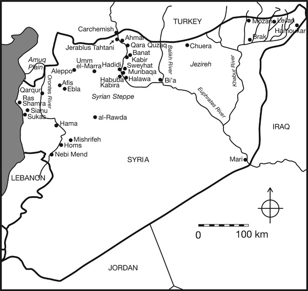
Map of Syria, showing the location of sites discussed in the chapter, most of which were occupied in the third millennium BC
regimes elevated agro-pastoral productivity to an unprecedented scale in antiquity. In contrast, all areas of western Syria depended principally on rain-fed agriculture, and several regions, particularly the Syrian steppe lands and the southern section of the middle Euphrates River Valley, received less than adequate precipitation, frequently making dry farming precarious (Wilkinson 1994: 499500, 2004: 41; Stein 2004: 6263). It might be this factor, along with the fact that several regions were constrained by topographical features that prevented the cultivation of wide tracts of land, that accounts in part for the smaller growth of Syrian urban settlements when compared to the cities of Sumer. At the same time, Syrias variety of subsistence pursuits, which combined agricultural activities with pastoralism, not to mention the continuation of small-scale hunting in some areas, gave the regions some economic flexibility, and ensured a reliable flow of sustenance in the face of environmental uncertainties (Cooper 2006: 4445, 270271). The activity of trade in various raw materials, especially textiles, metals and timber, conveyed up and down the Euphrates River, as well as along eastwest overland routes that connected the Euphrates with trading partners to the west in the direction of Aleppo, the Idlib Plain, the Orontes Valley and the profitable ports on the Mediterranean Sea, further ensured ongoing economic success for some communities and was probably a factor that contributed to their moderate urban development during the third millennium BC.
Chronology
Most of the discussion here focuses on developments during the third millennium BC, when many parts of western Syria and the middle Euphrates experienced urban growth and contacts with the Sumerian city-states of southern Mesopotamia (). This period is the Early Bronze Age, which has been divided up into several sub-periods: EB I, II, III and IV. Absolute dates for these sub-periods, obtained from radio-carbon determinations, correlations between well-formulated pottery sequences and their correspondences to reliably dated artefacts, still require considerable refinement. Moreover, the sequences of western Syria and the middle Euphrates Valley require additional work to be properly synchronised with one another. For the present, rough dates for each phase or phases are presented here. EB I is generally thought to begin c .32003100 BC, but its end-date is uncertain and has consequently been lumped together with EB II. The end of EB II is fixed c .2600 BC for the middle Euphrates and c. 2700 BC for Western Syria (roughly speaking Early Dynastic IIIa in Sumer). The dating has been largely influenced by the appearance of the unique Red-Black Burnished Ware (RBBW, known also as Early Transcaucasian Ware and Khirbet Kerak Ware) since it was a major diagnostic trait among the ceramic assemblages of western Syria. Although traditional arguments have tended to place the appearance of RBBW at the beginning of the Southern Levants EB III, around c .2700 BC, more recent studies have suggested that it may have appeared as early as the end of the fourth millennium and become widespread in the Amuq plains by 2800 BC (Philip and Millard 2000: 280; Mazzoni 2002: 71). We hesitate to push western Syrias EB III back to an early date on the basis of this type of artefact alone, and so for the moment, we continue to assign western Syrias EB III to around 2700 BC, until a greater understanding of chronological developments for this elusive period has been achieved.

