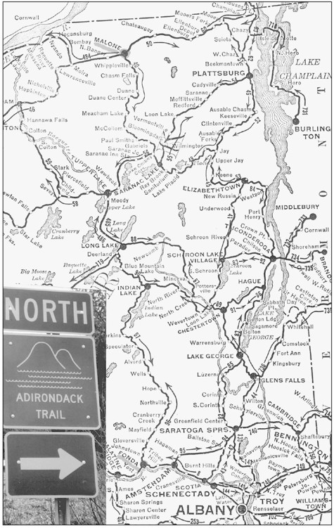
State Route 30A-30 was not always the Adirondack Trail. In its formative years, it was called the Sacandaga Trail. It was, at one time, Route 54. It did not go north to Malone; it went west at Speculator and ended in Utica. On the old touring maps, todays Route 30A from Fonda through the cities of Johnstown and Gloversville and on to Mayfield was Route 148. In the village of Mayfield, its path intersected with Route 30 from Amsterdam. When it reached Northville, it crossed the Northville Bridge over the Sacandaga River and passed through the village. A section of Route 30 between Sacandaga Park and Northville was Route 152 at that time. A 1932 map of the Adirondack Trail included several different route numbers: 30 to Wells, 8 to Speculator, 10 to Indian Lake, 28 to Blue Mountain Lake, 28N to Long Lake (where it became 10 again), 365 to Tupper Lake, and 10 to Paul Smiths and Malone. It is obvious that todays Route 30 all the way through the mountains to Malone was made up of many sections of roadway.
Along The Adirondack Trail
Donald R. Williams
Copyright 2004 by Donald R. Williams
9781439615881
Published by Arcadia Publishing
Charleston, South Carolina
Printed in the United States of America
Library of Congress Catalog Card Number: 2004107303
For all general information contact Arcadia Publishing at:
Telephone 843-853-2070
Fax 843-853-0044
E-mail sales@arcadiapublishing.com
For customer service and orders:
Toll-Free 1-888-313-2665
Visit us on the Internet at www.arcadiapublishing.com
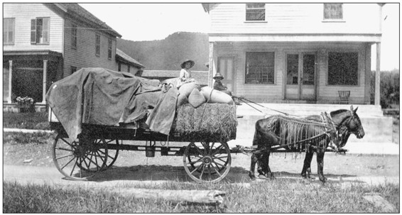
The Adirondack Trail had a varied history. It was much like a puzzle; many parts were constructed and put together to make the northsouth route of today. One of the first recorded indications of the Adirondack Trail appeared on a 1780 map as Canada Island, in the Sacandaga River near Hope, a Native American trail to Canada. In 1850, a plank road was built from Fonda to Gloversville, and that road became a public highway in 1904. The road south from Malone to Tupper Lake was surveyed in the 1850s, and one from Lake Pleasant to Long Lake was authorized in 1855. The road from Northville to Lake Pleasant was constructed in 1858, and the entire route from Fonda to Speculator and west was designated Route 54, the Sacandaga Trail, in 1900. Macadam was added to the road from Gloversville to Northville in 1908 and added on to Wells in 1912. New sections, including Route 152 from Sacandaga Park to Northville, were built when the Sacandaga Valley was flooded in 1930. The new macadam road from Speculator to Indian Lake became a reality in 1955. The state legislature officially put all the routes together in 1962 and created the Adirondack Trail.
Table of Contents
ACKNOWLEDGMENTS
The collection of photographs and stories herein is part of my 50-year accumulation of Adirondackia. They add to that patchwork of Adirondack history and lore found in my other two Images of America books, The Adirondacks: 18301930 and The Adirondacks: 19311990. My quest to seek out and record those many Adirondack stories is made possible only by those who willingly share the past with me. Thank you to each and every one who reads this and knows that your sharing brought this book to life.
Donald R. Williams
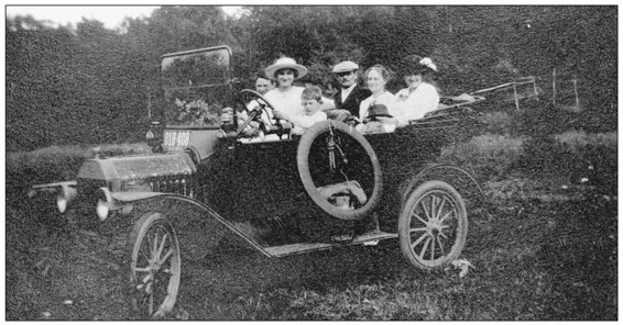
Once automobiles came on the Adirondack scene, the call for macadam roads became loud and clear. Section by section, the Adirondack Trail evolved from a dirt road to a hard-topped highway. Loading the family into the car and taking a tour along scenic byways became a national pastime. Old news clippings reported items such as A gang of Italians were taken up to the neighborhood of Stony Creek [on Route 30] to begin work on the new macadam road at that place in April 1910 and An automobile party from Philadelphia passed through Northville on their way to Lake Pleasant in June 1910. One Adirondack innkeeper lamented, It means goodbye to our horses; I suppose we will have to put in cars now to meet the wants of our up-to-date guests. He was right.
INTRODUCTION
The Adirondack Trail, designated a New York State Scenic Byway in 1992, provides a northsouth route through the heart of the Adirondack Mountain region. It begins at the Mohawk River at Fonda and ends at Malone, near the Canadian border. The New York State Scenic Advisory Board oversees the New York State Scenic Byways program, which is managed by the department of transportations Landscape Architect Bureau.
Entering Route 30A, the Adirondack Trail, at New York State Thruway exit 28, Fonda-Fultonville, places the traveler in Caughnawaga country, original homeland of the Iroquois tribe of Mohawks. On Route 5, just west of Fonda, the Blessed Kateri Tekakwitha practiced Christianity among her tribe at the site of a Native American castle and todays Kateri Shrine and Mohawk-Caughnawaga Museum. The copper dome of the 1836 Greek Revival courthouse, which houses one of the best genealogical libraries in the country, can be seen in the center of Fonda Village.
Uphill from the Mohawk Valley at Fonda are the once fertile farmlands of the regions farmers. The Sammons farm, a short distance up the road, is designated by a state marker. The Sammons family typifies the Mohawk farm family who chose to join the patriots during the Revolution to protect their homes and farms. Sampson Sammons and his three sons served faithfully in the Revolution, and descendant Simeon Sammons became a colonel in the Civil War. The Sammons family cemetery is on the hill just off Route 30A on the Sammonsville Road.
At Johnstown, the first of the Route 30A cities, the Johnson Hall Historic Site with the restored 1763 baronial mansion of Sir William Johnson, is open to the public, as are other buildings constructed in the 1760s and 1770s: one of the few Colonial courthouses still in use, old Fort Johnstown, the homesite of suffragist Elizabeth Cady Stanton, and an early schoolhouse and tavern. The site of one of the last battles of the Revolution is marked with appropriate plaques, and a War of 1812 camping site borders Route 30A.
Johnstown and its twin city, Gloversville, were once known as the Glove and Leather Capital of the World. Those industries are well represented at the Fulton County Museum, as well as at glove and leather outlets in Gloversville. The city has a Colonial cemetery, and in the Kingsborough section, a New England common surrounded by early homes that are said to have included stops on the Underground Railroad. Gloversville also has an 1838 church, a World War II veterans monument, and the restored Glove Theater, flagship of the Schine movie enterprise.
Outside of Gloversville, the Adirondack Trail becomes Route 30 and enters the Adirondack foothills and Adirondack Park. It passes Riceville, Mayfield, Cranberry Creek, and Sacandaga Parkall Great Sacandaga Lake settlements. The 1790 Federalist-style Rice Homestead is open to visitors, and the old Fonda, Johnstown, and Gloversville Railroad station stands in Sacandaga Park. Much of the remaining railroad bed throughout the county is being developed into a rail trail for hikers, skaters, and bikers.
The Northville Bridgeonce the terminus of the Fonda, Johnstown, and Gloversville Railroadwas a collecting site for the Adirondack logs, which were floated down the Sacandaga River during the great river drives beginning in the 1850s. Enterprising settlers to the north also made shingles, initialed them, and sent them down the river to be taken out and counted at the Northville sawmill.
Next page

