Lonely Planet Kids - Amazing World Atlas
Here you can read online Lonely Planet Kids - Amazing World Atlas full text of the book (entire story) in english for free. Download pdf and epub, get meaning, cover and reviews about this ebook. year: 2014, publisher: Lonely Planet Global Limited, genre: Art. Description of the work, (preface) as well as reviews are available. Best literature library LitArk.com created for fans of good reading and offers a wide selection of genres:
Romance novel
Science fiction
Adventure
Detective
Science
History
Home and family
Prose
Art
Politics
Computer
Non-fiction
Religion
Business
Children
Humor
Choose a favorite category and find really read worthwhile books. Enjoy immersion in the world of imagination, feel the emotions of the characters or learn something new for yourself, make an fascinating discovery.

- Book:Amazing World Atlas
- Author:
- Publisher:Lonely Planet Global Limited
- Genre:
- Year:2014
- Rating:4 / 5
- Favourites:Add to favourites
- Your mark:
- 80
- 1
- 2
- 3
- 4
- 5
Amazing World Atlas: summary, description and annotation
We offer to read an annotation, description, summary or preface (depends on what the author of the book "Amazing World Atlas" wrote himself). If you haven't found the necessary information about the book — write in the comments, we will try to find it.
Amazing World Atlas — read online for free the complete book (whole text) full work
Below is the text of the book, divided by pages. System saving the place of the last page read, allows you to conveniently read the book "Amazing World Atlas" online for free, without having to search again every time where you left off. Put a bookmark, and you can go to the page where you finished reading at any time.
Font size:
Interval:
Bookmark:


How to Use This Book
The Amazing World Atlas makes it easy to find
the information you want.
These two pages will show you how it all works. Main entries begin with one of the seven continents:
North America, South America, Europe, Asia, Africa, Oceania and Antarctica, in that order.
Following each continental entry are pages devoted to regions and countries within that continent.
If you want to know about a specific region or nation, you can look it up in the index.
LOCATOR MAP
A small illustrated
map shows you where
in the world each
continent is located.
CONTINENT HEADING
Each continent has four pages dedicated
to it. The first two pages give you an
overview of the continent, and general
information, such as its location,
climate and people.
MAPS
Illustrated maps show the main geographical
features of the continent, such as mountains,
rivers and valleys, and some of the most
interesting animals, buildings and other
things to be found there.
NEIGHBOURING COUNTRIES
On some maps neighbouring
countries are also labelled.
COUNTRY LABELS
On each map are labels for
the countries or nations
included in the continent.
CIRCLED NUMBERS
The numbers refer to the Map Key
box. Look up the number attached
to the image and the boxed text
will tell you what it is.
AMAZING HEADING
The third and fourth pages give
you a deeper insight into what
the continent is like.
PHOTOGRAPHS
There are lots of photographs in the
Atlas, showing you what real life is like in
the places you are reading about. On this
page you can see some local wildlife, and
physical features of the landscape.
SUPER STATS
This text gives you some key facts
about the continent, such as the
highest mountain, most populated
place or highest temperatures.
FAMOUS... HEADING
This caption tells you about
some of the famous sons and
daughters of each continent.
TOP 10
The Top 10 feature
shows images and
information about some
of the amazing people,
places and wildlife to be
found in the continent.
REGIONAL HEADING
Continental entries are followed by regional entries.
These give more detail about the various countries
and regions within the continent. Most regional entries
cover four pages and, like the continental entries, the
first two give you an overview of the country, nation
or region, and the third and fourth provide more detail.
ENTRY HEADING
This heading tells you
which part of the continent
(countries and/or regions)
the entry covers and, where
necessary, lists the countries
or states included.
MAP
The map illustrates the
region covered, and
labels the countries or
states included.
CAPTIONS
Captions give information about
real life, culture and history,
valuable resources, statistics or
landmarks found in the region.
ABBREVIATIONS
To save space, some words are
abbreviated in this Atlas. They
are listed below, with an
explanation for each one.
C = degrees Celsius
F = degrees Fahrenheit
mm = millimetre
cm = centimetre
m = metre
km = kilometre
km = square kilometre
kph = kilometres per hour
in = inch
ft = foot
yd = yard
sq mi = square mile
mph = miles per hour
g = gram
kg = kilogram
oz = ounce
lb = pound
INDEX
At the back of the book you will find
an alphabetical index, where you can
look to see if a particular place is
covered in the atlas. The numbers
following each index entry refer to
page numbers.
There are also grid references that
refer to the world map at the start of
the index. These numbers and letters
are in normal type.
EXAMPLE:
Cambodia 8689, 106109 L6
Cameroon 114117 , 126129 H7
Canada 2633 C4

App Store
Google play
lonelyplanetkids.com

Planet Earth in Space
Our planet, Earth, is one of eight that orbit the Sun.
It is the only one we know of that can support life,
though the quest continues to find others.
The Sun is one of many stars in our galaxy, but its the only one we can see during
the day, due to its size and the heat it exudes. At its centre the Suns temperature is
about 15,000,000C (27,000,000F). And it measures over 1,000,000 km (620,000 mi)
across its diameter its so big that a million Earths could fit inside it!
The surface of Earth is very young compared with that of some of the other planets.
This is because it has changed a lot since it was first formed. Movement below
the surface, such as earthquakes and erosion by water, reshapes it over time.
More than two-thirds of Earth is covered in water. Ours is the only planet
on which liquid water can exist, and water is essential for life.
The oceans also help keep the temperature stable, another factor
that is important for life. They are aided in this by the carbon
dioxide in our atmosphere, which traps warm air. This
is known as the greenhouse effect.

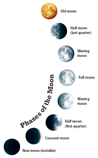
The light of the Moon is really light from the Sun, which reflects off the
Moons surface. As the Moon orbits Earth , we on Earth see this
reflected light at varying angles. Thats why the shape of the Moon
appears to us to change. It takes about 29 days for the Moon to orbit
Earth, cycling through all the phases and arriving at the beginning again.
Our Unknown World
Up until the twentieth century we had no
complete maps of the planet. Then we began to
be able to take pictures of Earth from space. This
allowed us to fill the gaps in our knowledge of the
world. Pictures from space also help us predict
the weather, and are especially useful in showing
where hurricanes and other storms are going.
Earth seen from space is a beautiful sight. Its
mostly blue because of all the water on its surface,
and its often known as the blue planet.
Neptune
Neptune is the eighth
planet from the Sun, and
the fourth largest. Its a
gas planet, with a rocky
Font size:
Interval:
Bookmark:
Similar books «Amazing World Atlas»
Look at similar books to Amazing World Atlas. We have selected literature similar in name and meaning in the hope of providing readers with more options to find new, interesting, not yet read works.
Discussion, reviews of the book Amazing World Atlas and just readers' own opinions. Leave your comments, write what you think about the work, its meaning or the main characters. Specify what exactly you liked and what you didn't like, and why you think so.


