ADLARD COLES
Bloomsbury Publishing Plc
50 Bedford Square, London, WC1B 3DP, UK
This electronic edition published in 2018 by Bloomsbury Publishing Plc
BLOOMSBURY, ADLARD COLES and the Adlard Coles logo are trademarks of Bloomsbury Publishing Plc
First published as The Message of the Clouds in Great Britain 2017
This expanded Bloomsbury edition 2018
Copyright Oliver Perkins, 2017, 2018
Oliver Perkins has asserted his right under the Copyright, Designs and Patents Act, 1988, to be identified as Author of this work
For legal purposes the Acknowledgements constitute an extension of this copyright page
All rights reserved
You may not copy, distribute, transmit, reproduce or otherwise make available this publication (or any part of it) in any form, or by any means (including without limitation electronic, digital, optical, mechanical, photocopying, printing, recording or otherwise), without the prior written permission of the publisher. Any person who does any unauthorised act in relation to this publication may be liable to criminal prosecution and civil claims for damages.
A catalogue record for this book is available from the British Library
Library of Congress Cataloguing-in-Publication data has been applied for
ISBN: 978-1-4729-6018-4 (PB)
ISBN: 978-1-4729-6016-0 (eBook)
ISBN: 978-1-4729-6017-7 (ePDF)
Designed by CE Marketing
To find out more about our authors and their books please visit www.bloomsbury.com where you will find extracts, author interviews and details of forthcoming events, and to be the first to hear about latest releases and special offers, sign up for our newsletter.
CONTENTS
FOREWORD
by TOM CUNLIFFE

Its so much better, and far more fun, to be able to read the sky and make your own conclusions about the weather than it is to punch a button on a computer and let someone else tell you whats happening. Of course, were all going to use modern methods, but its like anything else, if you understand the essence of the subject, you know what questions to ask the computer and can make a lot more sense of its answers. Thats what Ollys book does. It leads you gently through the guts of what I used to call single-station weather forecasting.
Ive known Olly since he was a small boy. I was impressed then by his keenness and the intelligent questions he asked. Now hes a strapping young teenager, hes moved on and is already representing his country in sailing. His first book is so good that my Yachtmaster Instructor candidates would do well to read it. Driven by instantly available internet forecasting, the subject of weather lore is falling off most peoples radar. This is a poor state of affairs because, out at sea, there may only be the sailor to decide on whats happening and what to do about it.
Olly has given us all a helping hand. I learned something from this book. Ill bet you do too.
Tom Cunliffe, author, TV presenter and Yachtmaster Instructor Examiner
www.tomcunliffe.com
FOREWORD
by DUNCAN WELLS

I met Olly when we were both on the ChartCo Stand at the 2017 Southampton Boat Show, signing copies of our books. I love weather, especially simplifying it so that my students can understand it more readily. I am also a great fan of Alan Watts Instant Weather Forecasting. And lets face it, if that book was good enough for Bernard Moitessier to refer to when he was unsure of the weather during the 1968 single-handed Golden Globe race then its good enough for me. So I was intrigued at what Olly was offering. I bought a copy of his original book and found it absolutely brilliant; a must for anyone who does anything outside and for whom the weather might be important. Its for sailors of course but gardeners, walkers, golfers everyone really, wherever they are in the world, will get something from this book.
And so while I thought that it was admirable to have a self-published book, as it was at the time, I thought it would be better to have a big publishing name behind it. I contacted my publisher, Janet Murphy at Bloomsbury, and here is the result. With Reading the Clouds, Olly has expanded the original content and added more photos, diagrams, tables and explanations, as well as more tips and hints on identifying and interpreting cloud formations.
Thanks to Olly you will be able to look at the sky mid morning and tell with certainty what the wind will be doing and whether or not it will rain during the afternoon. Thats worth knowing.
Duncan Wells, principal of Westview Sailing, author of Stress-Free Sailing and Stress-Free Motorboating
www.westviewsailing.co.uk
GETTING TO KNOW THE BASICS
This chapter will explain the basics of weather so that you can understand why clouds indicate different types of weather. It covers clouds, air masses, depressions, fronts, anticyclones and some forecasting rules. If you are not particularly interested in the theory behind how the weather works but want to start predicting what will happen as soon as possible, skip to the section on the cross-winds rule .
CLOUDS
When air can no longer carry any more water vapour the water condenses, forming clouds. This often happens because cold air cannot hold as much water vapour as warm air. Approximately every 100m of altitude the air rises, it cools 1C. The air cannot keep rising because it reaches a level where the air gets warmer the higher it goes. This is called a temperature inversion, and there is a permanent one called the tropopause which is about 12km high in the temperate regions.
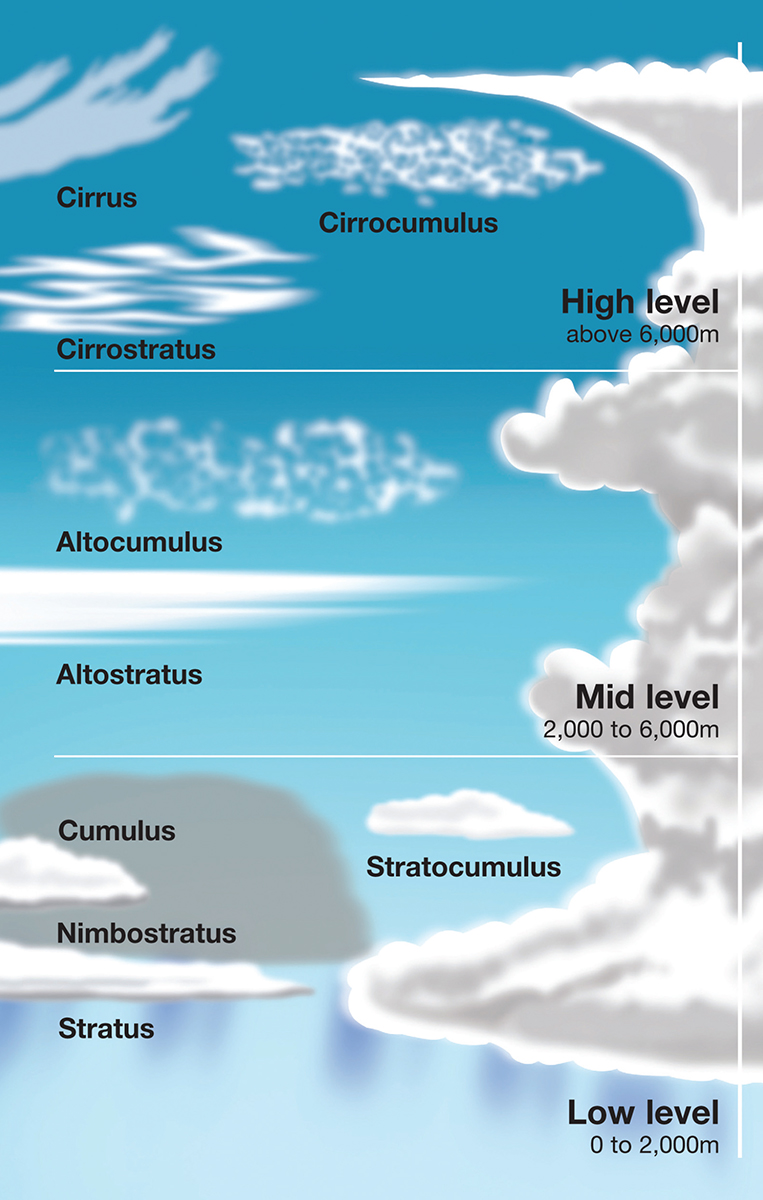
Almost all clouds are contained in the troposphere which is the layer below the tropopause. The clouds are split into three layers. The lowest layers are the clouds less than 2km above the ground and their names do not have a prefix. The next layer contains clouds up to 5km high and they all start with the prefix alto-. The highest layer is made of ice crystals and is over 5km high, they start with prefix cirr-. There are also clouds which extend through more than one layer.

The different types of cloud
The low clouds are: cumulus, the iconic cotton wool cloud; stratus, the featureless cloud that covers the whole sky; and stratocumulus clouds, which are a mix of the two.
The middle clouds are: altocumulus clouds, which look like smaller cumulus clouds; and altostratus, which are just higher stratus clouds.
The high clouds are: cirrus clouds, the thin wispy clouds; cirrostratus clouds, thin layers of ice crystals that can form a halo; and cirrocumulus clouds, which are higher versions of altocumulus clouds.
The clouds that span more than one layer all produce rain. They are nimbostratus, which is the dull rain-bearing cloud, and cumulonimbus


