
Published by The History Press
Charleston, SC 29403
www.historypress.net
Copyright 2008 by Claudette Holliday
All rights reserved
All images are courtesy of the author.
First published 2008
Second printing 2010
Third printing 2011
e-book edition 2013
ISBN 978.1.62584.881.9
Library of Congress Cataloging-in-Publication Data
Holliday, Claudette, 1946
Remembering Lexington, South Carolina : good stewards in a new land / Claudette Holliday.
p. cm.
Includes bibliographical references.
print edition ISBN 978-1-59629-525-4
1. Lexington (S.C.)--History--Anecdotes. 2. Lexington (S.C.)--Biography--Anecdotes. I. Title.
F279.L47H65 2008
975.773--dc22
2008022675
Notice: The information in this book is true and complete to the best of our knowledge. It is offered without guarantee on the part of the author or The History Press. The author and The History Press disclaim all liability in connection with the use of this book.
All rights reserved. No part of this book may be reproduced or transmitted in any form whatsoever without prior written permission from the publisher except in the case of brief quotations embodied in critical articles and reviews.
This book is dedicated to
Archie Baylis Corley
(18941988)

Contents
Preface
These stories are about the people, places and events of Lexington County.
My love of history began with my grandfathers stories. His name was Archie Baylis Corley. He was a farmer who descended from Swiss and German farmers, craftsmen, educators, statesmen and settlers in Saxe Gotha and the Dutch Fork more than two hundred years ago. Even though Mr. Archie died many years ago, people of our community still fondly remember both him and his stories about Lexington.
Lexington is facing many changes as we enter the twenty-first century. The greatest of these changes is its growth, which sometimes exceeds our ability to cope with its demands. However, we must be ever diligent in keeping our vision fixed upon that which is true and everlasting.
It is my purpose in passing along to you these stories of Lexington to keep the essence of Lexington aliveits character, its charm and its own unique place in South Carolinas history.
Acknowledgements
Jerry and MacLeod Bellune, editor and publisher, respectively, of the Lexington County Chronicle and Dispatch News, and staff deserve a special thank-you for their encouragement throughout the years.

PART I
First, A Wilderness

The Cherokee Path
In 1730, Surveyor General George Hunter mapped out the ancient American Indian trail known as the Cherokee Path. The path extended from Charleston to present-day Tennessee. As a trade route into the interior, it was significant in expanding the frontier and encouraging settlement in South Carolina. In fact, a trade route into the interior was a major consideration in selecting the location of the settlement of Charles Town.
The journey from Charles Town to Keowee (Clemson) took George Hunter and his surveyors fourteen days. Fort Congaree, about midway between Charles Town and Keowee, was located at the junction of two major Native American trade routes and was the result of a treaty between Colonel James Moore and Cherokee Charite Hayge. Settlement began, and the construction of Fort Prince George near Clemson soon followed. Fort Loudon, near current-day Maryville, Tennessee, on the Little Tennessee River, was built in 1752.

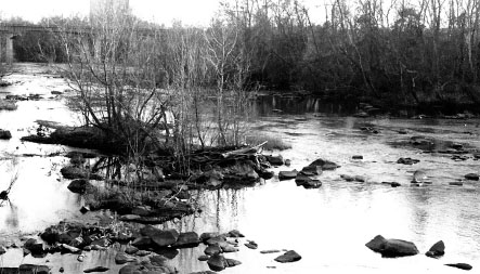
A scenic view of the Congaree River.
In Lexington County, the path enters the county in the south on the route from St. Matthews and runs through the Sandy Run Community, where Herman Geiger had his trading post. Herman Geiger was an early road commissioner who helped expand the footpath into a wagon road system.
From Sandy Run, the path comes to the Congaree Creek at Fridays Ferry and Saxe Gotha. The old roadbed then goes through Cayce to Highway 1, where it follows Leaphart Road to Mineral Springs Road. From there, the path joins Highway 378 and proceeds northwesterly, maintaining its name of Old Cherokee Road. The path turns off Old Cherokee Road onto Beechwood Drive and then again turns onto Highway 378, where it travels into Saluda County to Saluda Old Town.
Once in Saluda County, the path follows the Newberry Road to Ninety Six, Cokesbury, Hodges, Due West, Anderson, Pendleton and on to Fort Loudon.
Many have traveled the path. In addition to the early natives of the Chicora, Cherokee, Edisto, Saluda and Yamassee tribes, De Soto and Don Pardo also discovered the New World along part of our Cherokee Path.
As goods of our own making are shipped to twenty-first-century markets, the old trade route remains an important factor in the consideration of commerce and land development.

Indian Trader Herman Geiger
Today, a granite monument marks the spot where Herman Geiger most likely built his trading post near the Congaree River, twelve miles south of Columbia, just inside the Calhoun County line. In the early days of Lexingtons history, Herman Geiger was instrumental in establishing trade in Saxe Gotha Township.
Geiger left for Carolina from the Swiss village of Wydnau in September 1736 with his father, Hans Jacob Gyger, former cantonal governor; his mother, Margareta Feerin; his wife, Elizabeth Habluzel; his children, Catherina and Hans Conrad; and his brothers and sisters, Catherina, Hans Heinrich, Maria Barbara, Hans Jacob and Margareta.
The Geiger family arrived in Charles Town on February 1, 1737. After their arrival, they proceeded to New Windsor and then on to Saxe Gotha, where Herman Geiger established an Indian trading post. Upon leaving New Windsor, John Tobler, author of the South Carolina Almanac, considered the departure of the three Geiger men a good riddance, declaring Herman a useless manwho swore and cursed. Geiger family lands were surveyed in Saxe Gotha above Toms Creek, next to those of Martin Friday.
One of Geigers most notable accomplishments in the Carolina backcountry was his role in improving the Cherokee Path into a highway from Charleston to Saxe Gotha during the 1740s, allowing expanded trade.
Early records of the Upper House of the South Carolina Assembly show that Herman Geiger was appointed commissioner of a bridge and causeway at Beaver Creek on June 9, 1747. It was also reported on the same date that Geiger was appointed a commissioner of roads extending from Charles Town into Amelia Township. He also served the colonial governor in his dealings with the Native Americans.
Geiger died in 1751 at age forty-four. It is not known for certain how Herman Geiger met his end, but family legend has it that the Indian trader was clubbed by a local Native American, who was angered by Geigers attentions toward his squaw. Geiger was then dragged to the creek (probably the Savannah Hunt Creek) and left to die or was drowned. It is accepted knowledge that Geigers remains are not interred at the memorial site located in the Geiger Cemetery, formerly called Tyler (Taylor) Field Cemetery.
Next page


