IMAGES
of America
MOORESTOWN
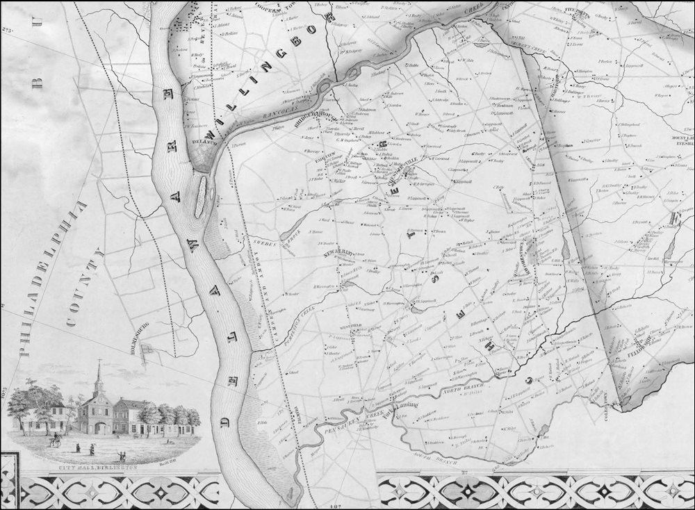
Incorporated on November 6, 1688, Chester Township originally included all the territory east of the Delaware River, from the south side of the Rancocas Creek to the south branch of the Pennsauken Creek and east into what is now Mount Laurel and Cherry Hill. The western section became Cinnaminson Township in 1860, and in 1922, Moorestown officially separated from Chester Township, which changed its name to Maple Shade in 1945. This 1849 map of Burlington County was published in Philadelphia by Smith & Wistar. (Courtesy of Library of Congress.)
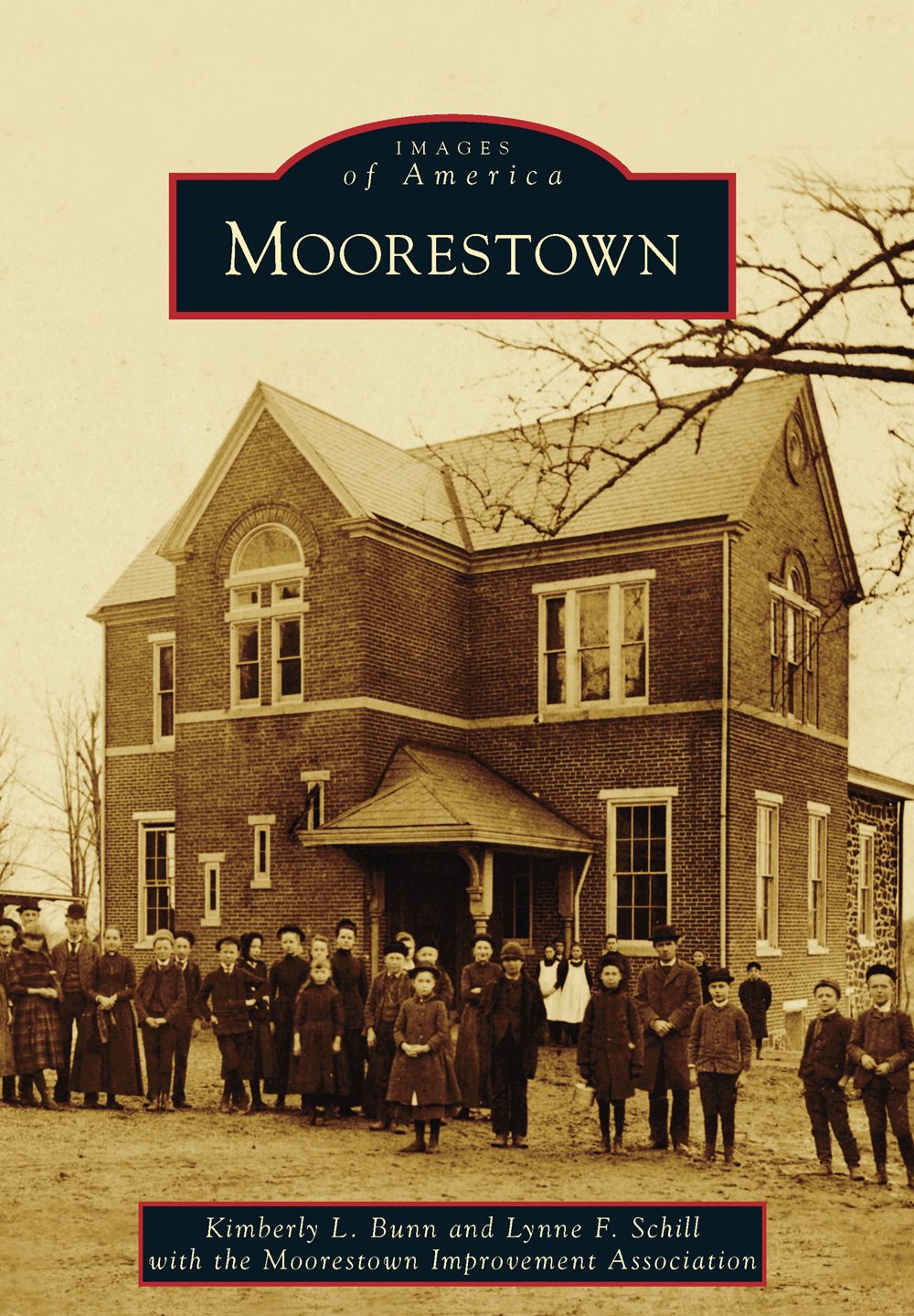
ON THE COVER: The Friends Academy, located on East Main Street at the head of Chester Avenue, was built in 1785 on land purchased by the Friends Meeting from Ephraim Haines. The one-room, stone schoolhouse faced away from Main Street to overlook the valley. One of the original stone walls is visible on the right rear of this photograph, which shows the academy and its students in 1889. (Courtesy of Moorestown Friends School.)
IMAGES
of America
MOORESTOWN
Kimberly L. Bunn and Lynne F. Schill
with the Moorestown Improvement Association

Copyright 2014 by Kimberly L. Bunn and Lynne F. Schill with the Moorestown Improvement Association
ISBN 978-1-4671-2234-4
Ebook ISBN 9781439648032
Published by Arcadia Publishing Charleston, South Carolina
Library of Congress Control Number: 2014933313
For all general information, please contact Arcadia Publishing:
Telephone 843-853-2070
Fax 843-853-0044
E-mail
For customer service and orders:
Toll-Free 1-888-313-2665
Visit us on the Internet at www.arcadiapublishing.com
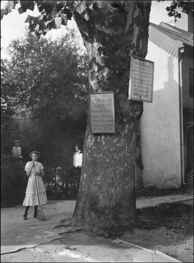
In 1740, Henry Warrington planted the buttonwood tree at the southwest corner of the Friends cemetery for use as a hitching post. It became a bulletin board where important notices were attached. The sign on the left in this c. 1890 photograph reads, The British Army passed under these trees after evacuating Philadelphia June 1778. (Courtesy of Moorestown Improvement Association [MIA].)
CONTENTS
ACKNOWLEDGMENTS
First and foremost, the authors would like to thank the Historical Society of Moorestown and its tireless pursuit of the towns history. This book would not have been possible without the help of Bill Archer, Stephanie Herz, and Lenny Wagner of the society and their generous willingness to share time, photographs, and knowledge. Unless otherwise credited, the images included here were provided by the Historical Society of Moorestown.
We would also like to thank the Moorestown Friends School, which offered unlimited access to its library of photographs and history. We must also thank Bill Newborg at the Moorestown Community House, the fire departments, the churches, the wonderful staff of the Moorestown Library, and the numerous businesses and individuals who offered information and photographs. We cannot express enough our gratitude to our husbands, Matthew Bunn, for looking after hearth and home, and David Schill, for the hours of scanning. We would be remiss if we did not acknowledge the past officers of the Moorestown Improvement Association who provided a vast amount of knowledge through detailed meeting minutes that are the basis for much of the book. Finally, we would like to offer our appreciation for the literary works of James C. Purdy and George DeCou, whose detailed, and sometimes baffling, accounts of early life in Moorestown were indispensable. Any discrepancies are due to the challenges of piecing together many conflicting stories and clues from the past.
We dedicate this book to all those individuals and organizations, past and present, who have worked to preserve the history and heritage of Moorestown.
INTRODUCTION
The Lenni Lenape, who called themselves the Original People, lived in bark houses called wigwams and traveled with the seasons between what we now know as Pennsylvania, New Jersey, and Delaware. They were the first residents of what is now Moorestown, with evidence of camps at Swedes Run near the Rancocas Creek and along the Pennsauken Creek and near Indian Springs on the Ridge, the high point of the area along which Main Street now runs. Densely forested with an ample supply of freshwater, this was undoubtedly a beautiful setting in which to live.
The earliest landowner of record was William Biddle, who received his portion of land from William Penn in 1677. Of this share of land, he sold a portion on Rancocas Creek in 1686 to Thomas Rodman of Rhode Island and another section along the Ridge to the west to Thomass brother John Rodman. There is no record that these men ever settled here.
On September 25, 1681, the West Jersey Assembly authorized the building of a road that would connect the English settlements at Burlington in the north and Salem in the south. The work of clearing the road began in 1682 along what were mostly American Indian trails that were invariably the easiest paths, including one along the Ridge that probably went between the native camps. It was called both the Kings Highway and Old Salem Road. It ran through what was to become Haddonfield and Moorestown and then crossed the Rancocas Creek at Hollinsheads Ferry.
In 1682, John and Sarah Roberts, William and Mary Matlack, and Timothy and Rachael Hancock were the first English settlers to arrive on the shore of the north branch of the Pennsauken Creek. There, so the story goes, they lived in caves or dugouts along the side of the hills until logs could be felled and small homes built. Each of these families had secured portions of the land in what was then West Jersey before they left England. They built homesteads on large fertile tracts. John Rudderow, William Clarke, Robert Stiles, and Thomas French quickly followed. Around the same time, John Borton, John Hollinshead, and the Hooten family built homesteads on the banks of the Rancocas Creek and began farming the land.
By the early 1700s, the area was known as Chester Township. It was a vast collection of farms spread throughout the area between the Rancocas and Pennsauken Creeks and from the Delaware River into the edges of what we know as Mount Laurel and Cherry Hill. The early settlers were members of the Religious Society of Friends, also known as Quakers, who gathered in homes for worship until the first Friends Meeting was erected and schools were built. Businesses followed, and soon there were tanneries, blacksmith shops, and, of course, taverns. These gathered along the Ridge, close to an easy supply of freshwater at the Indian Springs, and gradually became a village.
In 1742, Thomas Moore opened a tavern on the west end of the village. Moore began buying and selling tracts of land, becoming what may have been our first real estate agent. The village is referred to on some early maps as Moorfield or Mooresfield and the Pennsauken Creek as Moors Creek. The village became officially known as Moorestown in 1802, when the first post office was opened.
As the years passed, villages sprang up throughout Chester Township, including Westtown, New Albany, Fairview, Bridgeboro, Palmyra, Rivertown, Colestown, Centerton, Maple Shade, Stanwick, and North Bend. A border change with Evesham Township gave us our present eastern border. In 1860, Cinnaminson broke off, taking the villages to the west within its borders. The village of Moorestown officially withdrew from Chester Township in 1922 and became the Township of Moorestown. The last vestige of the original Chester Township officially changed its name to Maple Shade in 1948.
Next page

