Contents
Guide

Front cover image: The America Ground in 1811.
Back cover image: The old brig Noahs Ark, converted into a home. (Hastings Museum)
First published 2021
The History Press
97 St Georges Place,
Cheltenham,
Gloucestershire,
GL50 3QB
www.thehistorypress.co.uk
Steve Peak, 2021
The right of Steve Peak to be identified as the Author of this work has been asserted in accordance with the Copyright, Designs and Patents Act 1988.
All rights reserved. No part of this book may be reprinted or reproduced or utilised in any form or by any electronic, mechanical or other means, now known or hereafter invented, including photocopying and recording, or in any information storage or retrieval system, without the permission in writing from the Publishers.
British Library Cataloguing in Publication Data.
A catalogue record for this book is available from the British Library.
ISBN 978 0 7509 9776 8
Typesetting and origination by Typoglyphix, Burton-on-Trent Printed in Turkey by Imak
eBook converted by Geethik Technologies

CONTENTS
ACKNOWLEDGEMENTS
The three people who gave me the most help with this book are unfortunately no longer with us: Barry Funnell, Ion Castro and Davd Padgham. I helped Barry when he was researching and writing his large pamphlet The America Ground, published in 1989, the first and only reliable history of the America Ground to date. Shortly before Barry died, he offered to help me produce another history of the America Ground by drawing on new material that had come to light since 1989. He also passed on to me copies of many of his pictures and documents, as did my friends and local historians Ion and David when I told them what I was hoping to do. Both have since died.
Also giving me very useful help have been Ken Brooks, Denis Collins, Professor Fred Gray, Bob Hart, Brian Lawes, Bill Montgomery and Ian Shiner, plus the Hastings Reference Library (especially Gill Newman), Hastings Museum and Art Gallery, The Keep at Falmer and the Old Hastings Preservation Society.
I am a retired journalist and writer/publisher, and have spent most of my life in Hastings. I have written several local history books, including Fishermen of Hastings (first published in 1985), A Pier Without Peer (on the history of the Hastings and St Leonards piers) and Mugsborough Revisited (describing the local background to Robert Tressells famous novel The Ragged Trousered Philanthropists, which was set in Hastings and St Leonards). I am the honorary curator of the Hastings Fishermens Museum, and have been on Hastings Councils Museum Committee for over 30 years.
Steve Peak, 2021
IMAGE CREDITS
Many of the pictures in this book come from a collection put together by the author over many years, including the generous donations from the archives of Barry Funnell, Ion Castro and David Padgham. The pictures that do not come from that multi-person collection have been kindly loaned by the following people and organisations:
Hastings Museum |
Hastings Reference |
Library |
The Keep, |
Brighton |
British Museum |
Ken Brooks |
Ordnance Survey |
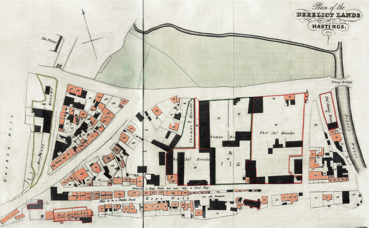
The America Ground in 1829.
INTRODUCTION
The America Ground is 8 acres of Hastings town centre that in the early nineteenth century was an open piece of beach, apparently beyond the borough boundary and with no obvious owner, which was gradually occupied by a thousand or more people (many of them squatters) who lived and worked there until they were all evicted by the government in 1835.
But in the first three decades of the nineteenth century, the Ground despite being out of town played a key role in the expansion of Hastings during a crucial period in its 1,200-year history. The Ground was a combined industrial and housing estate providing many services to the towns developers, plus much housing for the many workers that were needed. The Grounds seeming freedom from local authority control also created something of a radical libertarian atmosphere, and one of the names the Ground acquired was America, after the newly independent former British colony.
However, the Grounds apparently almost uncontrolled sovereignty meant there was often conflict between the actual occupants as they tried to settle which of them was going to occupy what piece of landlord-free land. The increasing frequency of these clashes eventually prompted central government the probable legal owner of the Ground to take control of it in 1828. All the settlers were given notice to quit, and from 1850 what was once almost a new American state on British soil became an upmarket suburb of the increasingly popular seaside resort of Hastings.
There follows a summary of the America Grounds history, all of which is described in more detail in the rest of this book.
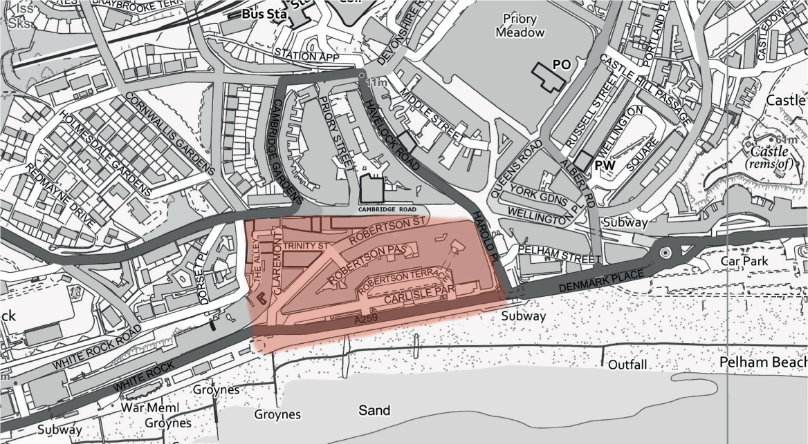
Hastings town centre. The America Ground was the coloured area, between Harold Place in the east and The Alley in the west, going as far inland as Cambridge Road.
SUMMARY
The America Ground lies in the Priory Valley, which around the time of the Battle of Hastings in 1066 was a natural harbour, with the town of Hastings then based on top of the White Rock headland, on the west side of the Valley. Over the following centuries the harbour gradually silted up, and Hastings moved into the Bourne Valley, where the Old Town is today.
In 1578 some prominent local townspeople persuaded Queen Elizabeth to fund the turning of the marshy Priory Valley into a haven, a sheltered closedin dock, like a marina. But after 2,000 (about 920,000 in todays money) had been spent on the scheme in about 1580, the rest of the finance went missing and construction stopped. However, a raised embankment had been built across most of the mouth of the Valley from the west side, lying roughly where Cambridge Road is today, as a barrier providing defence from the sea. This embankment immediately created a valuable road out of Hastings to the west, and as such was also to become the inland boundary of the America Ground two centuries later.
But the embankment also blocked some of the Valleys drainage channels, turning the bottom of it into marshland. This had a major effect on the expansion of the town, as the Valley could not be built upon until the mid-nineteenth century.
By the early 1700s the Priory Valley had become a mixture of this low-lying marsh, with farmland on the slopes, and much shingle piled up against the c.1580 embankment. The Priory Stream ran down the east side of the Valley into the sea where Harold Place is now.

