Also by Keith Smith
Local General Orders of the Anglo-Zulu War 1879 , 2005, 2008
Select Documents: A Zulu War Sourcebook , 2006, 2009
Studies in the Anglo-Zulu War , 2007, 2008
A Lexicon of Zulu Military Units , 2008
Harry Smiths Last Throw: The Eighth Frontier War, 18501853 , 2011


F RONTLINE B OOKS , L ONDON
The Wedding Feast War: The Final Tragedy of the Xhosa People
This edition published in 2012 by Frontline Books, an imprint of
Pen & Sword Books Limited,
47 Church Street, Barnsley, S. Yorkshire, S70 2AS
www.frontline-books.com
Email info@frontline-books.com or write to us at the above address.
Copyright Keith Smith, 2012
The right of Keith Smith to be identified as the author of this work has been asserted by him in accordance with the Copyright, Designs and Patents Act of 1988.
Publishing history
First edition published in 2010 by Keith Smith.
Second edition published in 2012 by Frontline Books Ltd.
All rights reserved. No part of this publication may be reproduced, stored in or introduced into a retrieval system, or transmitted, in any form, or by any means (electronic, mechanical, photocopying, recording or otherwise) without the prior written permission of the publisher.
Any person who does any unauthorised act in relation to this publication may be liable to criminal prosecution and civil claims for damages. CIP data records for this title are available from the British Library.
ISBN 978-1-84832-681-1
ISBN 978-1-78337-670-4
Typeset in Caslon Pro by JCS Publishing Services Ltd,
www.jcs-publishing.co.uk
Printed and Bound by CPI Group (UK) Ltd, Croydon, CR0 4YY
Contents
How dull it is to pause, to make an end,
To rust unburnishd, not to shine in use!
Alfred, Lord Tennyson, 18091892
Illustrations
Genealogical Tables
The tables illustrate the various clans of the Xhosa people.
Maps
1 Cape Colony in 1806
2 The Advancing Frontier, 18061865
4 Mfengu and Gcaleka Borders, August 1877
Map 1 was specially commissioned for this work. Map 2 is a conflation of three maps found in Edges of War , by John Milton, by permission. Map 3 is based on a map in BPP 1635. Map 4 is based on a map in BPP C.2000, while Maps 5 and 6 are based on maps in BPP C.1961. Map 7 is from General Cunynghames memoirs My Command in South Africa 18741878 . Map 8 is from The Frontier War Journal of Major John Crealock 1878 , by Chris Hummel (ed.), by permission.
Plates
Pre-1877
Ninth Frontier War
Plates , private collection
Plate , from Streatfields Reminiscences of an Old Un
Plate , Ron Sheeley collection
Plates , authors collection
1. Genealogy of the Tshawe, the Royal Xhosa Clan
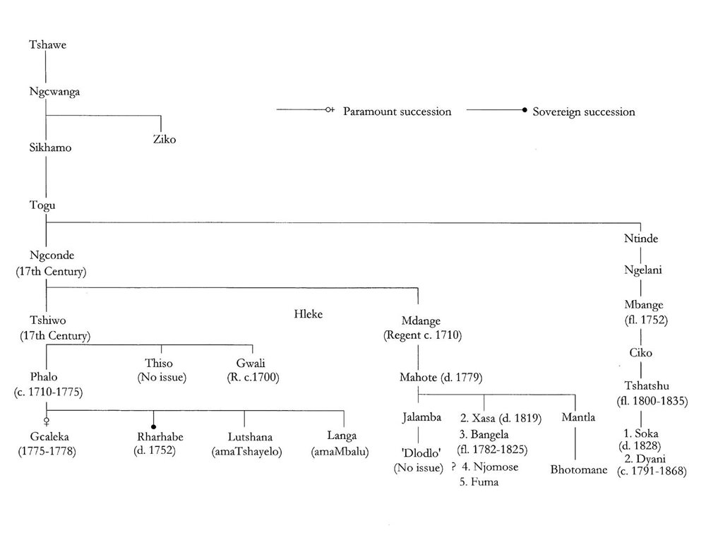
2. Genealogy of the Rharhabe
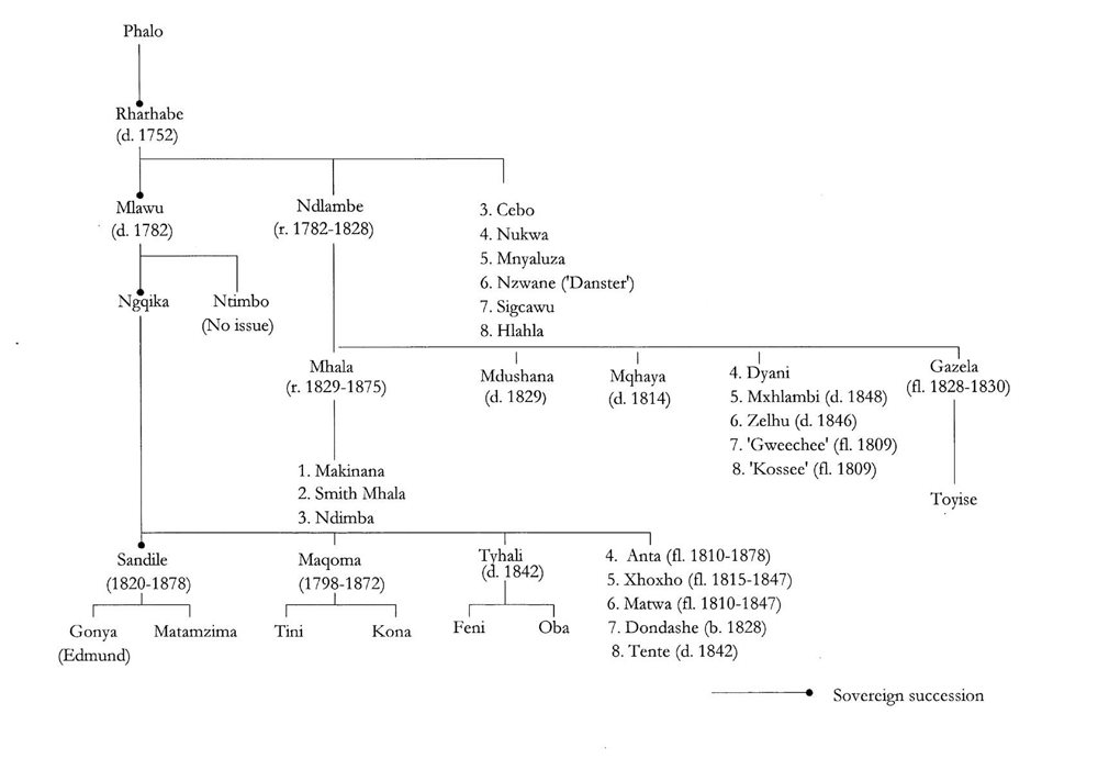
3. Genealogy of the Gcaleka and Gwali
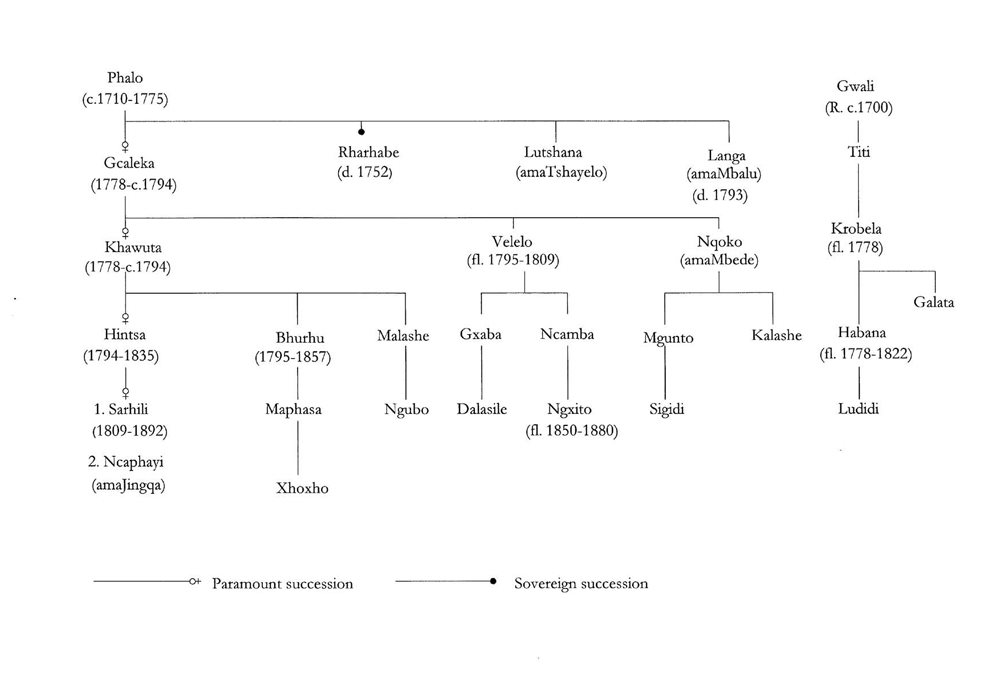
4. Genealogy of the Tshayelo and Mbalu
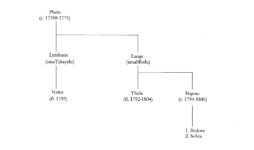
5. Genealogy of the Gqunukhwebe
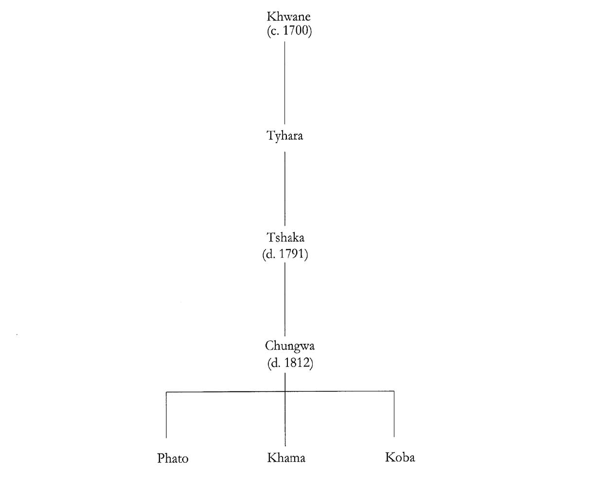
Acknowledgements
This work on the Ninth Cape Frontier War of 187778 might be regarded as a prequel to the Zulu War of 1879. The war involved some of the same British units, and many of the men, that would later fight the Zulus. In the following pages we shall witness the formation of some of the colonial units, meet the leaders of African levies, witness the first rise to prominence of familiar names and observe a political crisis of major proportions.
All wars are terrible but this one was particularly tragic: it was the last of nine to be fought by Dutch and British colonists against the indigenous people of South Africa and was to bring the Xhosa to their lowest ebb, depriving them of their land and wealth (their cattle), compelling them to work for wages and thus gradually lose touch with a vibrant culture which had nourished them for more than a thousand years.
Once more I am indebted to those curators and staff of museums and libraries who have been so helpful with my enquiries. In this respect, I must mention the staff of The National Archives, Kew, who have survived the merging of the Family Records centre with their usual aplomb, while still managing to deliver files for researchers in a remarkably short time; the National Army Museum, Chelsea; the Regimental Museum of the Royal Welsh, Brecon; the Campbell Collections in Durban; the Cory Library at Rhodes University and the Albany Museum, both in Grahamstown; the Cape Archives in Cape Town; the State Library of New South Wales, Sydney.
Part I of this work owes much to the endeavours of Nol Mostert, whose Frontiers is a monument to fastidious research, especially for the early yearsof the infant colony. It is only with the advent of British rule that one isable to make use of the British Parliamentary Papers which document the development of the Cape from 1806. Similarly, I have leaned heavily upon Michael Spicer in Part II, whose unpublished thesis The War of Ngcayecibi provided much valuable information. To both of these gentlemen I owe my thanks.
During my researches I have visited the Eastern Cape three times and must thank Rob Speirs of King Williams Town for his assistance during two of these visits, and for a most helpful tour of the Transkei battlefieldsin the area.
Some of the maps have been especially commissioned for this work, while others are contemporary documents. In the case of the map labelled The Advancing Frontier, I am indebted to Juta & Co., Cape Town, publishers of John Miltons work The Edges of War , for their kind permission to use three of the maps found in that work, which I have combined into a single map. The map depicting the area of operations in the Pirie bush is taken from The Frontier War Journal of Major John Crealock, 1878 , edited by Dr Chris Hummel, and is reproduced here by kind permission of the publishers, the Van Riebeeck Society, Cape Town.
The task of copy-editing the typescript fell to Steve Williamson of JCS Publishing Services. In this endeavour, Steve has saved me from both error and embarrassment and I thank him most sincerely for so doing. It goes without saying that any remaining blemishes are my own.
On a more personal level, it is something of a clich to note that we live in a small world, but it really was true for me in mid-2009. I had some dealings with a financial institution and had spoken to one of its representatives on the telephone to arrange a rendezvous. It was clear that my contact was South African so, when we met a few days later, I asked him from where he came. He replied, the Eastern Cape. My interest was kindled and I pressed him further: Where in the Eastern Cape? You probably dont know it, but near Fort Beaufort.
Next page
