Ron Adkison et al. - Hiking Grand Staircase-Escalante & the Glen Canyon Region
Here you can read online Ron Adkison et al. - Hiking Grand Staircase-Escalante & the Glen Canyon Region full text of the book (entire story) in english for free. Download pdf and epub, get meaning, cover and reviews about this ebook. year: 2018, publisher: Falcon Guides, genre: Home and family. Description of the work, (preface) as well as reviews are available. Best literature library LitArk.com created for fans of good reading and offers a wide selection of genres:
Romance novel
Science fiction
Adventure
Detective
Science
History
Home and family
Prose
Art
Politics
Computer
Non-fiction
Religion
Business
Children
Humor
Choose a favorite category and find really read worthwhile books. Enjoy immersion in the world of imagination, feel the emotions of the characters or learn something new for yourself, make an fascinating discovery.

- Book:Hiking Grand Staircase-Escalante & the Glen Canyon Region
- Author:
- Publisher:Falcon Guides
- Genre:
- Year:2018
- Rating:5 / 5
- Favourites:Add to favourites
- Your mark:
Hiking Grand Staircase-Escalante & the Glen Canyon Region: summary, description and annotation
We offer to read an annotation, description, summary or preface (depends on what the author of the book "Hiking Grand Staircase-Escalante & the Glen Canyon Region" wrote himself). If you haven't found the necessary information about the book — write in the comments, we will try to find it.
Ron Adkison et al.: author's other books
Who wrote Hiking Grand Staircase-Escalante & the Glen Canyon Region? Find out the surname, the name of the author of the book and a list of all author's works by series.


Hiking Grand Staircase-Escalante & the Glen Canyon Region — read online for free the complete book (whole text) full work
Below is the text of the book, divided by pages. System saving the place of the last page read, allows you to conveniently read the book "Hiking Grand Staircase-Escalante & the Glen Canyon Region" online for free, without having to search again every time where you left off. Put a bookmark, and you can go to the page where you finished reading at any time.
Font size:
Interval:
Bookmark:
The Grand Staircase is the most remote and seldom-visited section of the Glen Canyon region covered in this book. It is spectacular and contains the most extensive network of slot canyons in Utah. By way of contrast, the Paria CanyonVermilion Cliffs Wilderness, at the southwest corner of the Glen Canyon region, is so popular that annual visitation there almost outnumbers all other hiking areas in the Glen Canyon region combined.
The Grand Staircase marches northward from the North Rim of the Grand Canyon to the 9,000-foot edge of Utahs High Plateaus. The colorful succession of risers in the staircase include, from south to north, the Shinarump Cliffs, the Vermilion Cliffs, the White Cliffs, the Gray Cliffs, and the Pink Cliffs. Each cliff band is separated by progressively higher terraces. The Grand Staircase can be viewed to best advantage from a scenic overlook off of US 89A, between Fredonia and Jacob Lake, both in Arizona. From that vantage point the landscape to the north in Utah indeed resembles a staircase, and for people inclined toward hiking and scenic driving, it is an alluring view.
Within the Grand StaircaseEscalante National Monument, the Grand Staircase is primarily drained by the Paria River, coursing 80 miles from Utahs High Plateaus to its confluence with the Colorado River at Lees Ferry. Gathering its waters in the Bryce Valley between the Paunsaugunt and Table Cliffs Plateaus, the river ignores the cliffs and terraces of the staircase and carves a deepening gorge through a succession of colorful, progressively older sedimentary rock formations. Once the river cuts the folded rocks of The Cockscomb on the eastern edge of the Grand Staircase, it meanders through broad valleys before plunging into the Paria Plateau. East of the monoclonal fold of The Cockscomb, younger rocks have returned to river level, and the river once again slices through much the same sequence of rock formations found in its upper reaches.
The Paria River carves the deepest canyon in the region through the Paria Plateau. It approaches 3,000 feet deep in places. Paria Canyon is also one of the regions longest backcountry journeys. Stretching nearly 40 miles from White House Trailhead to the canyons mouth at Lees Ferry on the Colorado River, the trail leads hikers through canyons renowned for their narrow slots. Paria Canyon straddles the UtahArizona border and is the only hike covered in this book that extends into Arizona.
Most of the hikes in the Grand Staircase/Paria River region are off-trail, following dry, easily passable washes through some of the finest narrows in the region.
WHY GO?
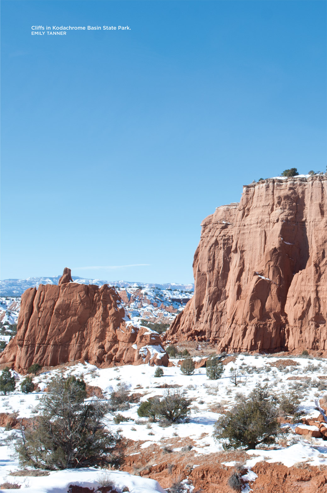
Kodachrome Basin State Park, a 2,240-acre preserve southeast of Bryce Canyon National Park, is a place of vivid colors and dramatic landforms. Punctuated by the white chimneys of sand pipes, and the orange cliffs, spires, and finlike ridges of Entrada Sandstone that dominate the basin, this is one of the more spectacular areas in southern Utah, a land renowned for its unique landscapes.
THE RUNDOWN
Start: Panorama Trailhead
Total distance: 5.4 miles, double loop
Hiking time: 3 to 3.5 hours
Difficulty: Moderately easy
Best seasons: Apr through early June; Sept through Oct
Trail surface: Stagecoach road and constructed trail, well defined
Trailhead access: 2WD (paved access)
Canine compatibility: Leashed dogs permitted
Water availability: None available; bring your own
Fees and permits: Day use fees apply
Land status: Kodachrome Basin State Park
Trail contact: stateparks.utah.gov/parks/kodachrome-basin/
FINDING THE TRAILHEAD

From UT 12 in the Bryce Valley town of Cannonville, Utah, 33 miles east of Panguitch, Utah, and US 89 and 36 miles west of Escalante, Utah, turn south onto Cottonwood Canyon Road (the Cottonwood Canyon Scenic Backway), signed Kodachrome Basin9. Follow this paved road south through Cannonville, then through the broad valley of the upper Paria River. You pass the junction with southwest-bound Skutumpah Road after 2.9 miles, and after 7.4 miles reach the end of pavement on Cottonwood Canyon Road. Turn left here, staying on the paved road, to enter Kodachrome Basin State Park.
Stop at the visitor center after 0.9 mile and pay a small day-use fee, then continue north 0.6 mile to the signed parking area for Panorama Trail, Grand Parade Trail, and Picnic Area.
The signed Panorama Trailhead is located on the left (west) side of the road, 1.6 miles from Cottonwood Canyon Road and 8.8 miles from Cannonville.
THE HIKE
This state park is like a national park in miniature. Its concentration of unusual landforms, good access, numerous short trails, and visitor services that include a general store, campground, and cabins combine to make the park a premier destination.
Six hiking trails traverse the park, most of them less than 1 mile in length. The exception is the Panorama Trail, a nearly level 2.9-mile loop that surveys what is perhaps the finest scenery the park has to offer. Panorama Point, an overlook just above the loop trail, affords an unparalleled vista across the parks colorful landscape. The 2.5-mile Big Bear Geyser Trail can be taken to extend the trip into a rewarding half-day hike.
One mile of the Panorama Trail is shared by hikers, mountain bikers, and stagecoach tours conducted by the park concessionaire at Trailhead Station from Easter week through mid-October. The remaining singletrack is shared by hikers and mountain bikers only. The Panorama and Big Bear Geyser Trails are the only trails open to mountain bikes in the park.
The sand pipes in the park add a unique dimension to a land dominated by unusual landforms. These white chimney-like spires, averaging 30 to 50 feet in height, are composed of coarse sand that is far more resistant to erosion than the overlying orange Entrada Sandstone. Geologists believe that long ago the park was a geothermal area, with hot springs and geysers much like Yellowstone National Park is today. After the springs and geysers ceased to flow, they filled with sand, and they are the white spires you see today.
The wide trail, narrower than a typical dirt road, begins behind the trailhead display sign and traverses a grassy flat studded with juniper, big sagebrush, rabbitbrush, and four-wing saltbush. From the start, you are surrounded by an array of orange Entrada Sandstone spires. Other spires you will see along the trail are the white sand pipes.
Many of the spires along the trail have been likened to familiar images and given fanciful names. Soon you reach the first, Fred Flintstone Spire, rising from bedrock, and just beyond it the trail forks after 0.3 mile, with the return leg of the loop branching left. Bear right and quite soon you reach the first of several short spur trails. It leads 100 yards to Old Indian Cave, a small shady alcove. This trail describes a loop and shortly returns to the main trail.
The trail ahead traverses a gently contoured basin covered in grass and studded with the gnarled trees of the pinyon-juniper woodland. Fine views reach west to the Pink Cliffs of the Paunsaugunt Plateau in Bryce Canyon National Park. After 0.6 mile, the stagecoach road branches left, and you bear right, following the singletrack ahead where the sign indicates Panorama Trail. A tall, slender sand pipe, Ballerina Spire, rises a short distance north of the trail. You curve around it and soon reach the 200-yard spur trail to Hat Shop, a concentration of orange Entrada spires capped by sandstone slabs.
Next pageFont size:
Interval:
Bookmark:
Similar books «Hiking Grand Staircase-Escalante & the Glen Canyon Region»
Look at similar books to Hiking Grand Staircase-Escalante & the Glen Canyon Region. We have selected literature similar in name and meaning in the hope of providing readers with more options to find new, interesting, not yet read works.
Discussion, reviews of the book Hiking Grand Staircase-Escalante & the Glen Canyon Region and just readers' own opinions. Leave your comments, write what you think about the work, its meaning or the main characters. Specify what exactly you liked and what you didn't like, and why you think so.