Matjaž Mikoš - Advancing Culture of Living with Landslides: Volume 3 Advances in Landslide Technology
Here you can read online Matjaž Mikoš - Advancing Culture of Living with Landslides: Volume 3 Advances in Landslide Technology full text of the book (entire story) in english for free. Download pdf and epub, get meaning, cover and reviews about this ebook. year: 2017, publisher: Springer, genre: Home and family. Description of the work, (preface) as well as reviews are available. Best literature library LitArk.com created for fans of good reading and offers a wide selection of genres:
Romance novel
Science fiction
Adventure
Detective
Science
History
Home and family
Prose
Art
Politics
Computer
Non-fiction
Religion
Business
Children
Humor
Choose a favorite category and find really read worthwhile books. Enjoy immersion in the world of imagination, feel the emotions of the characters or learn something new for yourself, make an fascinating discovery.
- Book:Advancing Culture of Living with Landslides: Volume 3 Advances in Landslide Technology
- Author:
- Publisher:Springer
- Genre:
- Year:2017
- Rating:4 / 5
- Favourites:Add to favourites
- Your mark:
Advancing Culture of Living with Landslides: Volume 3 Advances in Landslide Technology: summary, description and annotation
We offer to read an annotation, description, summary or preface (depends on what the author of the book "Advancing Culture of Living with Landslides: Volume 3 Advances in Landslide Technology" wrote himself). If you haven't found the necessary information about the book — write in the comments, we will try to find it.
Matjaž Mikoš: author's other books
Who wrote Advancing Culture of Living with Landslides: Volume 3 Advances in Landslide Technology? Find out the surname, the name of the author of the book and a list of all author's works by series.


![T. H. Logwood - Voter Fraud and the 2020 Presidential Election; “Joe Biden wins by a Miraculous Landslide” [with appendices]](/uploads/posts/book/259666/thumbs/t-h-logwood-voter-fraud-and-the-2020.jpg)


Advancing Culture of Living with Landslides: Volume 3 Advances in Landslide Technology — read online for free the complete book (whole text) full work
Below is the text of the book, divided by pages. System saving the place of the last page read, allows you to conveniently read the book "Advancing Culture of Living with Landslides: Volume 3 Advances in Landslide Technology" online for free, without having to search again every time where you left off. Put a bookmark, and you can go to the page where you finished reading at any time.
Font size:
Interval:
Bookmark:
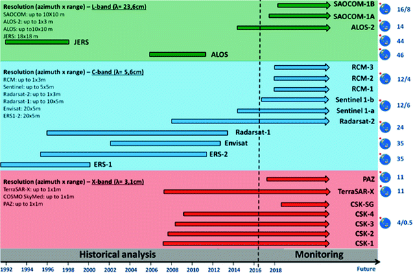
 The current availability of highly developed remote sensing technologies in the field of landslide detection, mapping and monitoring allows for rapid and easily updatable data acquisitions, improving the traditional investigation capabilities, even in hazardous or inaccessible areas, while granting at the same time the safety of the operators during the fieldwork. In this work various application of remote sensing techniques for landslide detection, mapping and early warning, from spaceborne to ground-based platforms are described. Among earth observation (EO) techniques in the last decades optical and radar images are very effective tools for these implementations, since very high spatial resolution can be obtained by means of optical systems (currently in the order of magnitude of tens of centimeters), and by the new generations of synthetic aperture radar (SAR) sensors designed for interferometric applications, with revisiting times of few days. At the same time in the recent years, ground-based remote sensing techniques have undergone a significant increase of usage, thanks to their technological development and quality data improvement, in terms of spatial resolution and accuracy, fast measurement and processing times, portability and cost-effectiveness of the acquiring instruments. In this paper, the potential of space-borne imaging techniques, ground-based remote sensing methods and the effectiveness of their synergic use in the field of landslide analysis is explored by reviewing their state of the art, and by analyzing various case studies, characterized by different slope instability processes, spatial scales and emergency management phases. After assessing the advantages and limitations of the proposed methods, further fields of applications are evaluated.
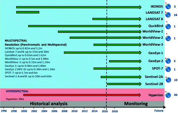
Font size:
Interval:
Bookmark:
Similar books «Advancing Culture of Living with Landslides: Volume 3 Advances in Landslide Technology»
Look at similar books to Advancing Culture of Living with Landslides: Volume 3 Advances in Landslide Technology. We have selected literature similar in name and meaning in the hope of providing readers with more options to find new, interesting, not yet read works.
Discussion, reviews of the book Advancing Culture of Living with Landslides: Volume 3 Advances in Landslide Technology and just readers' own opinions. Leave your comments, write what you think about the work, its meaning or the main characters. Specify what exactly you liked and what you didn't like, and why you think so.