A wise person once said that a culture can be measured by the resources it chooses to preserve. If thats true, then the state of California is an immense credit to American culture. The Golden State is blessed with an abundance of parks and preserves, including more than 20 units of the National Park System, 18 national forests, 137 federally designated wilderness areas, 275 state parks, and thousands of county and regional parks.
This huge mosaic of parklands celebrates Californias diverse landscape, which includes the highest peak in the contiguous United States (Mount Whitney, in the southern Sierra Nevada, at 14,495 feet) and the lowest point in the western hemisphere (Badwater, in Death Valley, at 282 feet below sea level). The state contains 20,000 square miles of desert, nearly 700 miles of Pacific coastline, an unaccountable wealth of snow-capped peaks and alpine lakes, a smattering of islands, and even a handful of volcanoes.
California also boasts its share of the worlds tallest living things, the towering coast redwoods. And it is the only state that is home to the worlds largest living trees (by volume), the giant sequoias. We can also brag of having the planets oldest living things, the ancient bristlecone pines.
Quite simply, California is a land of superlatives, and using this card deck is one way to get out and explore it. Whats great about the trails you hold in your hand is that they are suitable and fun for almost everybody. Bring along your children, your grandma, or even your spouse who thinks the great outdoors is all about mosquitoes and poison oak. Every trail in this deck was chosen because it offers a good payoff, a reason for going besides just for the exercise. These 50 trails will lead you away from pavement, exhaust fumes, and crowds, to places where youd rather be: sparkling waterfalls, scenic viewpoints, and peaceful forests.
And fortunately, this is Northern California, so all the right ingredients for hiking nirvana are here. With a wide variety of terrain, from the mountains to the sea, its always perfect hiking weather somewhere, no matter what season of the year. And no matter where you live, its only a short drive to somewhere spectacularoften only a few minutes. If you live in downtown San Francisco, you have a wealth of parks and preserves within an hours drivein Marin County and on the San Mateo County coast and hills. If you live in the suburbs of Sacramento, just an hour or two on the highway will put you in the Sierra Gold County foothills, or in the Tahoe high country. Residents of Modesto and Stockton can be standing in a mountain meadow in Yosemite National Park in the time it takes many people to commute to work. With this abundance of riches in our backyard, theres no reason not to get out and explore.
With a few exceptions, most of the hikes in this deck are less than 6 miles round-trip. Depending on your pace and number of stops, most hikes will take 2 to 4 hours to complete. In general, the hikes are not very steep, although some of them will surely give you an aerobic workout. Read the text on the back of the cards to get a feel for each trail before you set out, just so you know what you are in for. The routes themselves are marked on the maps, with the starting point clearly labeled.
When you do head out, remember to tread lightly and gently on this magnificent land. The basics are simple: Leave no trace of your visit. Pack out all your trash. Dont collect specimens of plants, wildlife, or even pine cones. Never carve into the trunks of trees. When youre following a trail, dont cut the switchbacks just to save time. Leave everything in nature exactly as you found it, because each tiny piece has its place in the great scheme of things.
If you choose to, you can go the extra mile, too. Pick up any litter that you see on the trail, and teach children to do the same. Carry an extra bag to hold collected litter until you get to a trash receptacle, or just keep an empty pocket for that purpose in your day-pack or fanny sack. If you have the extra time or energy, join a trail organization in your area or spend some time volunteering in your local park. Any small effort you make to help this beautiful planet will be repaid to you, many times over.
Text copyright 2009 by Ann Marie Brown.
Maps copyright 2009 Lohnes + Wright.
All rights reserved.
No part of this deck may be reproduced in any form
without written permission from the publisher.
ISBN : 978-1-4521-3201-3
Design by Kris Branco


GOLDEN GATE NATIONAL
RECREATION AREA
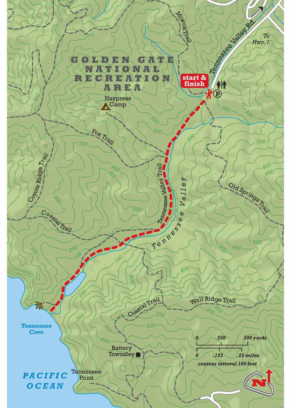
DISTANCE: 4.0 miles round-trip
HIKING TIME: 2 hours
SEASON: year-round
DIFFICULTY: easy
The Tennessee Valley Trail is the most popular trail in Golden Gate National Recreation Area and probably the most heavily used trail in all of Marin County. But dont let the crowds scare you away. The route is wide enough for everybody: bikers, hikers, runners, and parents pushing baby strollers. Or, time your trip for an early morning or a weekday.
Begin at Miwok Stables and head straight on the dirt path. The mostly level trail follows a creekbed between grassy ridges lined with coastal chaparral. Rabbits, deer, and bobcats can be seen in the quieter hours of the day. At 1.5 miles, the trail forks; bikers must stay on the wide road to the right but hikers take the single-track to the left. The trails rejoin 0.5 mile later as they pass a bird-rich lagoon and approach Tennessee Cove, a picturesque pocket beach where the steamship Tennessee wrecked in dense fog on its way to San Francisco in 1853.
Although Tennessee Beach is a great spot for surf watching, strong riptides make it unsafe for swimming. Consider adding on a half-mile hike up the northern bluff to a high coastal overlook before heading back the way you came.
From San Francisco, cross the Golden Gate Bridge and drive north on U.S. 101 for 4.0 miles. Take the Mill Valley/Stinson Beach/Hwy. 1 exit and continue straight for 0.6 mile to Tennessee Valley Rd. on the left. Turn left and drive 2.0 miles to the trailhead.
2 | OCEAN VIEW, LOST TRAIL
& FERN CREEK LOOP |
MUIR WOODS NATIONAL MONUMENT
DISTANCE: 3.4 miles round-trip
HIKING TIME: 1.5 hours
SEASON: year-round
DIFFICULTY: moderate
This small national monument with its awesome redwoods and dense ferns sees more than one million visitors annually. Winter and early spring are the least crowded seasons, but an early start anytime should provide a few hours of peace.
Start from the visitor center. The wide path traversing the canyon bottom passes the most impressive redwoods. Youll walk its length on your return; for now, bear right after 100 yards onto Ocean View Trail. Redwoods here are younger and smaller, interspersed with Douglas firs. The trail curves and climbs its way to a meeting with Lost Trail at 1.5 miles. Note this junction; but continue for 200 yards until Ocean View exits the forest below Panoramic Hwy. A hillside boulder between the trail and the road offers the trips sole long-distance view.
Next page

