Barstad - Best Easy Day Hikes Spokane/Coeur dAlene
Here you can read online Barstad - Best Easy Day Hikes Spokane/Coeur dAlene full text of the book (entire story) in english for free. Download pdf and epub, get meaning, cover and reviews about this ebook. City: Coeur dAlene Region (Idaho);Idaho;Coeur dAlene Region;Spokane Region (Wash.);Washington (State);Sp, year: 2018;2017, publisher: Falcon Guides, genre: Home and family. Description of the work, (preface) as well as reviews are available. Best literature library LitArk.com created for fans of good reading and offers a wide selection of genres:
Romance novel
Science fiction
Adventure
Detective
Science
History
Home and family
Prose
Art
Politics
Computer
Non-fiction
Religion
Business
Children
Humor
Choose a favorite category and find really read worthwhile books. Enjoy immersion in the world of imagination, feel the emotions of the characters or learn something new for yourself, make an fascinating discovery.

- Book:Best Easy Day Hikes Spokane/Coeur dAlene
- Author:
- Publisher:Falcon Guides
- Genre:
- Year:2018;2017
- City:Coeur dAlene Region (Idaho);Idaho;Coeur dAlene Region;Spokane Region (Wash.);Washington (State);Sp
- Rating:4 / 5
- Favourites:Add to favourites
- Your mark:
Best Easy Day Hikes Spokane/Coeur dAlene: summary, description and annotation
We offer to read an annotation, description, summary or preface (depends on what the author of the book "Best Easy Day Hikes Spokane/Coeur dAlene" wrote himself). If you haven't found the necessary information about the book — write in the comments, we will try to find it.
Barstad: author's other books
Who wrote Best Easy Day Hikes Spokane/Coeur dAlene? Find out the surname, the name of the author of the book and a list of all author's works by series.


Best Easy Day Hikes Spokane/Coeur dAlene — read online for free the complete book (whole text) full work
Below is the text of the book, divided by pages. System saving the place of the last page read, allows you to conveniently read the book "Best Easy Day Hikes Spokane/Coeur dAlene" online for free, without having to search again every time where you left off. Put a bookmark, and you can go to the page where you finished reading at any time.
Font size:
Interval:
Bookmark:

Best Easy Day Hikes
Spokane/Coeur dAlene
Best Easy Day Hikes Series
Best Easy Day Hikes
Spokane/Coeur dAlene
Second Edition
Fred Barstad


An imprint of The Rowman & Littlefield Publishing Group, Inc.
4501 Forbes Blvd., Ste. 200
Lanham, MD 20706
Falcon and FalconGuides are registered trademarks and Make Adventure Your Story is a trademark of The Rowman & Littlefield Publishing Group, Inc.
Distributed by NATIONAL BOOK NETWORK
Copyright 2018 The Rowman & Littlefield Publishing Group, Inc.
A previous edition of this book was published by Falcon Publishing, Inc. in 2012.
TOPO! Maps copyright 2018 National Geographic Partners, LLC. All Rights Reserved.
Maps by Melissa Baker The Rowman & Littlefield Publishing Group, Inc.
All rights reserved. No part of this book may be reproduced in any form or by any electronic or mechanical means, including information storage and retrieval systems, without written permission from the publisher, except by a reviewer who may quote passages in a review.
British Library Cataloguing in Publication Information available
Library of Congress Cataloging-in-Publication Data available
ISBN 978-1-4930-2978-5 (paperback)
ISBN 978-1-4930-2979-2 (e-book)
 The paper used in this publication meets the minimum requirements of American National Standard for Information SciencesPermanence of Paper for Printed Library Materials, ANSI/NISO Z39.48-1992.
Printed in the United States of America
The author and The Rowman & Littlefield Publishing Group, Inc. assume no liability for accidents happening to, or injuries sustained by, readers who engage in the activities described in this book.
Contents
Acknowledgments
Thanks to the people from the land management agencies who reviewed portions of my text: Lori Cobb from Riverside State Park, Steve Cristenson from Mount Spokane State Park, Sandy Rancourt from Turnbull National Wildlife Refuge, and Brian White from the Bureau of Land Management.
Thanks to Alex Hoppe for joining me while collecting information.
Most of all thanks to my wife, Sue Barstad, for all her computer help.
Introduction
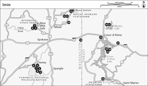
The Spokane House, close to the Little Spokane River, was the earliest nonNative American settlement in the Pacific Northwest. Established in 1810, the little trading post was widely known for its hospitality and is now in Riverside State Park. In 1872 the city of Spokane, currently Washingtons second largest, was established about 10 miles south of the Spokane House next to Spokane Falls on the Spokane River.
In 1878 Civil War general William Tecumseh Sherman established an army post at what is now Coeur dAlene, next to the spot where the Spokane River leaves Coeur dAlene Lake. From that beginning the city of Coeur dAlene grew to what it is today, getting a boost in the 1880s by the boom in the Silver Valley Mining District to the east.
If you live in the Spokane/Coeur dAlene area, you have a wide array of hiking opportunities at your doorstep. From the semiarid Columbia Plateau, to the timbered slopes of Mount Coeur dAlene and Mineral Ridge, and higher to the subalpine summit of Mount Spokane, hiking is available nearly year-round. If you are a visitor to the area, take the time to explore the possibilities. This book really just gives the hiker a taste of what is available close to these beautiful cities.
Spokane is at 1,900 feet elevation, near the poorly defined boundary between the grass and sagebrush of the semiarid Palouse Prairie to the southwest and the timbered plateau and well-watered mountains to the north and east. In general, rainfall (and snowfall) increases as you go farther east (toward Coeur dAlene) and/or gain altitude in this part of the Northwest. In Spokane the average January high temperature is 33F and the average low is 22F. The average July high temperature is 82F and the average low is 55F. The city of Coeur dAlene sits at 2,160 feet elevation in the pines next to the beautiful Coeur dAlene Lake. Coeur dAlene is generally slightly cooler and wetter than Spokane.
Deer and elk are common along most of the hikes included in this guide. These are generally docile animals, but both the bucks and the bulls can be somewhat aggressive during the fall rut (breeding season). Some cow elk seem to have a strong dislike for dogs and occasionally cause injuries. Bears and cougars are not often seen but are possible on all the hikes described here. Moose sightings are also possible on many of the hikes. Moose are large animals that should never be closely approached or challenged in any way. Rattlesnakes are possible on all but the highest elevation hikes in this book, and ticks can be a problem in the spring and summer.
Even on the easy hikes, weather conditions can change rapidly. The danger of adverse weather generally increases with elevation and the length of the hike. Always take clothes that are adequate for all possible conditions. Water, food, and a map should be taken along on all but the shortest hikes. A guidebook and GPS receiver are also very handy. Cell phone service can generally be had on at least part of most of the hikes described here.
Following are a few simple things you can do that will improve your chances of staying healthy while you are on your hikes:
First, check the weather report before heading into the mountains. Afternoon and evening thunderstorms are common from spring through early fall and can include heavy rain and hail as well as lightning. If a storm is approaching, get off ridgelines if possible and retreat to your car. Protective clothing is always a good idea.
Know the symptoms of both cold- and heat-related conditions, including hypothermia, heat stroke, and heat exhaustion. The easiest way to avoid these afflictions is to wear proper clothing, dress in layers, and keep adequately fed and hydrated.
On all but the shortest hikes, carry a backpack for your extra clothing and gear. This is much more comfortable than trying to carry this stuff in your hands.
Inform friends or relatives of your plans and when you plan to return.
If you are planning a long or difficult hike, be sure to get into shape ahead of time. This will make your trip much more pleasant as well as safer.
Know the basics of first aid, including how to treat bleeding, bites and stings, and strains or sprains. Always pack a first-aid kit.
One of the most important things to do is to be careful about your drinking water supply. On most of these hikes the best thing to do is to take along all the water you will need from a known safe source. All surface water should be filtered, chemically treated, or boiled before drinking.
If you have children along, keep a close eye on them. A few of the hikes described here have cliffs or steep drop-offs close to the trail. In some places stinging and/or poisonous plants are present, and there is always the chance, even though slim, of meeting a rattler. Children should carry a whistle to use if they are lostand only if they are lost.
Font size:
Interval:
Bookmark:
Similar books «Best Easy Day Hikes Spokane/Coeur dAlene»
Look at similar books to Best Easy Day Hikes Spokane/Coeur dAlene. We have selected literature similar in name and meaning in the hope of providing readers with more options to find new, interesting, not yet read works.
Discussion, reviews of the book Best Easy Day Hikes Spokane/Coeur dAlene and just readers' own opinions. Leave your comments, write what you think about the work, its meaning or the main characters. Specify what exactly you liked and what you didn't like, and why you think so.