Springer International Publishing AG 2017
Mohamed Ouessar , Donald Gabriels , Atsushi Tsunekawa and Steven Evett (eds.) Water and Land Security in Drylands 10.1007/978-3-319-54021-4_1
1. A Study of Water Stress on Olive Growing Under the Effect of Climate Change in South East of Tunisia
A. Hachani 1 , Mohamed Ouessar 1 and A. Zerrim 1
(1)
Laboratory of Eremology and Combating Desertification, Institut des Rgions Arides (IRA), 4119 Mdenine, Tunisia
Abstract
Climate change (CC) is a main issue of interest at the international as well as the national levels. It is important at this stage to do research to analyze impacts and adaptation strategies. The objective of this study was to evaluate the water stress of olive groves within the context of CC in the South East of Tunisia (watershed of Oum Zessar, Medenine) using hydrological modeling (HidroMORE model). Data on rainfall and temperature were collected from available stations, while those for future scenarios (Horizons 2030 and 2090) were obtained using the Coupled Model Intercomparison Project Phase 5 CMIP5 (GFDL HIRAM C360). In comparison with the reference period (19962005) and projecting increases in temperature of 1 and 5 C, as well as rainfall decreases of 5.4 and 20%, reference evapotranspiration (ETo) was simulated to increase by 39% and evapotranspiration under non-standard conditions (ETCadj) was reduced by 13% and 30%, respectively, for the 2030 and 2090 horizons. Thus, it is expected that the land suitable for olive cultivation will experience shrinkage and this cropping system would become increasingly problematic.
Keywords
Olive groves Climate change HidroMORE Water stress
Introduction
Climate change (CC) is a severe problem that the whole world is facing. It is now widely accepted that CC is already happening and further change is inevitable; over the last century (between 1906 and 2005), the average global temperature rose by about 0.74 C. This has occurred in two phases, from the 1910s to 1940s and more strongly from the 1970s to the present (IPCC ). So, it clear that CC presents a major challenge, a reality for all countries and for Tunisia in several sectors such as agriculture and especially for the olive tree sector, which occupies a strategic place in the Tunisian economy. It is in this framework that this work has been conducted to evaluate the water stress of olive tree within the context of climate change. The aims of this work are to analyze the situation related to climate variability and CC and future projections, then explore different climate scenarios and their effects on water stress of olive plantations in the South East of Tunisia (watershed of Oum Zessar, Mdenine) and finally suggest ways and policies of adaptation.
Presentation of the Study Site: Location
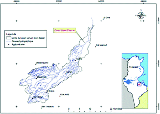
The watershed of wadi Oum Zessar was chosen as the site for this study. Based on previous research undertaken in the region (Talbi ). It stretches from the mountains of Matmata (Bni Khdache) in the south-west, crosses the Jeffara plain (via Koutine) and the saline depression ( Sebkha ) of Oum Zessar before ending in the Mediterranean (Gulf of Gabes).
Fig. 1.1
Location map of the watershed of wadi Oum Zessar (Ben Zaied )
Materials and Methods
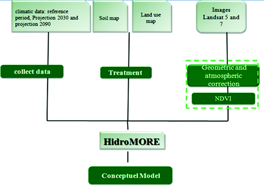
Our study was carried out in three main stages: the first was the preparation of climate data for the reference period and the future projection (2030 and 2090) periods. The second stage was devoted to data processing of sequential Landsat images to determine NDVI data cubes NDVI images were calculated from Landsat 5 and 7 TM images downloaded from USGS. The images were geometrically and atmospherically corrected. For joining all the images as bands in a unique image we have to create the images cube sized to the total area. Some modifications were carried out for the soil and land use maps which would be considered as inputs for the HidroMORE hydrological model. The realization of a conceptual model to extract and explore different climate scenarios and their effects on water stress in olive plantations has been the third step (Fig. ).
Fig. 1.2
Methodology flowchart
Daily Data for Temperature and Rainfall for the Future Period
The Geophysical Fluid Dynamics Laboratory (GFDL)
Climate models are important tools for improving our understanding of and the predictability of climate behavior on seasonal, annual, decadal, and centennial time scales. The Geophysical Fluid Dynamics Laboratory has been one of the world leaders in climate modeling and simulation for the past 50 years. NOAAs Geophysical Fluid Dynamics Laboratory (GFDL) builds models that are aimed at benefiting society, such as hurricane research and prediction, seasonal forecasting, and understanding and projecting climate change. HiRAM, the GFDL global HI gh R esolution A tmospheric M odel, was developed with a goal of providing an improved representation of future climate change and significant weather events in a global climate model. Simulations with two HiRAM models have been provided to the Coupled model intercomparison project 5 (Taylor et al. ) or through any of the other Earth System Grid (ESG) federated gateways. The ESG data portal web pages make it possible to search for the specific output of interest to a user. A user may search using any combination of model, variable, experiment, frequency (e.g., monthly, daily, 3 hourly), and modeling realm (e.g., atmosphere, ocean, sea ice).
The HidroMORE Model
HidroMORE is considered an operational model allowing the calculation of the superficial water budget with a limited number of input data; they can be estimated from remote sensing or measured by agrometeorological stations, reducing the necessity of adjustments or calibrations. Another relevant aspect of HidroMORE is its capacity to detect the water stress of vegetation, which can be obtained by the soil water balance. HidroMORE implements the FAO-56 dual crop coefficient and water stress, pixel by pixel, in broad areas and it is assisted by satellite images to determine cover parameters, leading to estimates of the basal crop coefficient ( Kcb ) and cover factor ( fc ). The crop coefficient is multiplied by the reference evapotranspiration (ETo) to estimate the crop water use (ETC). For that, HidroMORE performs a soil water balance in each pixel of the study zone, determining ETc by the FAO-56 methodology. The greatest strength of the model is the calculation of ET using the FAO 56 dual crop coefficient, which is applied pixel by pixel in the study area and is based on the derivation of the basal crop coefficient from multispectral images using a relationship between NDVI and Kcb (Gonzlez-Piqueras ).
Description of the Input Variables Required By HidroMORE
To implement the model, raster maps of soil properties, land use, NDVI images and meteorological variables such as precipitation and temperature are needed. Once the model is run, raster maps of precipitation, ETo , ETc, ETCad,j defined as the crop evapotranspiration under non-standard conditions which is the evapotranspiration from crops grown under management and environmental conditions that differ from the standard conditions and calculated using a water stress coefficient Ks, percolation (Direct recharge), irrigation, and runoff are obtained. The model also brings the possibility of obtaining detailed information for specific pixels. The input data are introduced into HidroMORE as raster images, but some information, like meteorological information, is only available for the station in maps or images format (Fig. ).
