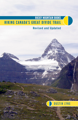
Hiking Canadas
GREAT DIVIDE TRAIL

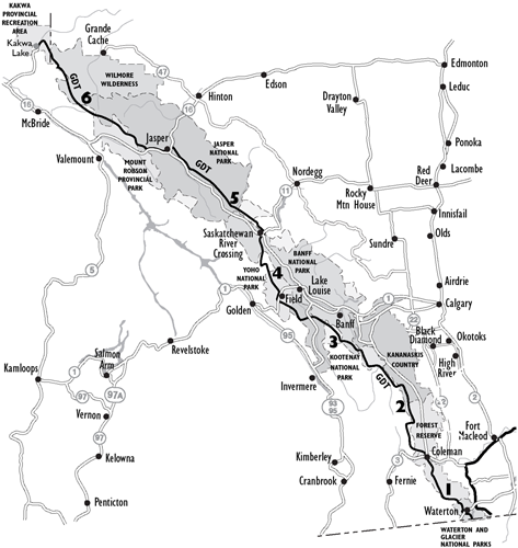
SECTIONS
1.Waterton to Coleman
2.Coleman to Kananaskis
3.Kananaskis to Field
4.Field to Saskatchewan River Crossing
5.Saskatchewan River Crossing to Jasper
6.Jasper to Kakwa Lake
Copyright 2007 Dustin Lynx
All rights reserved. No part of this publication may be reproduced, stored in a retrieval system, or transmitted in any form or by any meanselectronic, mechanical, audio recording, or otherwisewithout the written permission of the publisher or a photocopying licence from Access Copyright, Toronto, Canada.
Rocky Mountain Books
www.rmbooks.com
Cover design by Jacqui Thomas
All cover and interior photographs provided by Dustin & Julia Lynx unless otherwise noted.
Rocky Mountain Books gratefully acknowledges the support of the Canada Council for the Arts, the British Columbia Arts Council, the Province of British Columbia through the Book Publishing Tax Credit, and the Government of Canada through the Canada Book Fund for our publishing activities.
About the author
Dustin and Julia Lynx hiked the 4,300-kilometre Pacific Crest Trail from Mexico to Canada in 1994. Looking for a way to continue north, the couple hiked the Great Divide Trail in 1996. Dustin Lynx has continued hiking and skiing on the GDT every year since. The GDT is a natural route in the Canadian Rocky Mountainsinspirational, captivating, challenging. Now, a decade after his first journey on the trail, Dustin recognizes the GDT as an important influence in his own life and that of his family.
Contents
Trail Sections
Other Information
Disclaimer
The actions described in this book may be considered inherently dangerous activities. Individuals undertake these activities at their own risk. The information put forth in this guide has been collected from a variety of sources and is not guaranteed to be completely accurate or reliable. Many conditions and some information may change owing to weather and numerous other factors beyond the control of the author and publisher. Individual climbers and/or hikers must determine the risks, use their own judgment, and take full responsibility for their actions. Do not depend on any information found in this book for your own personal safety. Your safety depends on your own good judgment based on your skills, education and experience.
It is up to the users of this guidebook to acquire the necessary skills for safe experiences and to exercise caution in potentially hazardous areas. The author and publisher of this guide accept no responsibility for your actions or the results that arise from anothers actions, choices or judgments. If you have any doubt as to your safety or your ability to attempt anything described in this guidebook, do not attempt it.
Acknowledgments
There are limitless stories to tell about all the people who have contributed in some way to this guidebook. I sincerely thank all of them. One person in particular is key to the existence of this book. Julia Lynx, who is now my soul-mate, took a chance and walked the Pacific Crest Trail with me. She helped to plan and prepare for our thru-hike of the Great Divide Trail in 1996. Together we gathered data and she encouraged me to write this guidebook.
Friends, Family and Other Helpful People:
Julia, Roche and Tenaya Lynx
Aaron Phoenix
Barbara and Rod Dewhirst
David and Diane Simon
Agnes Bauer
Roy and Jill Howard
Bob, Sally and Katherine Hodges
Mateo Antonelli
Ernie Bauer
Jerry Auld
Doug Mouser
Randy Kading
Chris Townsend
Royce and Sherrill Robertson
John Dunn
Rich Botto
Wayne Van Velzen
Hugo Mulyk
May Torgerson
Brian Patton
Marion Harrison
Gillean and Tony Daffern
Rocky Mountain Books
Edwin Knox
Jenny L. Feick and Dave Higgins, co-founders of the Great Divide Trail Association
The Whyte Museum of the Canadian Rockies
Paul Leech The Trail Wizard
Paula Duncan
Brad Vaillancourt
Miro Rak
Carl Potter
Chris Willett
Jean-Guy Bergeron
Jim Thorsell
Bart Robinson
Karsten Heuer
Marmot
Lindy
Micheal Kwek
John Barge
Chic Scott
Gemtrek
Contributors Welcome
I encourage all users of the Great Divide Trail to contribute their observations and experiences on the GDT forum at www.rmbooks.com. If I use your information in the next edition of the guidebook, I will include your name in the acknowledgments. I encourage exploration and trail finding to bridge segments of trail that depend on roads. I would also love to update all the GPS waypoints and create a downloadable tracklog for GPS users. Thank you in advance.
Introduction
This guidebook describes the variety of trails that link together to form the Great Divide Trail (GDT), which follows the Continental Divide. The Great Divide Trail does not exist as a formal, signposted trail. The route consists of trails, cutlines, roads and some off-trail, cross-country sections that loosely follow the Divide from the international boundary in Waterton Lakes National Park to Kakwa Lake near the middle of the Canadian Rockies chain.
This book attempts to renew interest in the GDT, a route that originally began as an idea in the 60s. The GDT started to materialize in the 70s when a dedicated group of volunteers built a few sections of the trail outside of the national parks. Later, however, support for the trail waned and the impetus for a formal GDT route fell by the wayside.
While the original concept promoted the GDT as a backbone trail for an integrated trail system, my vision of the GDT is that it will be a flexible route that takes advantage of a myriad of existing trails close to the Divide with the hiker choosing alternatives depending on weather, trail conditions and logistics.
The main route of the GDT is 1191.4 km long, 63 per cent in Alberta, the rest in British Columbia. The route crosses the Continental Divide over 30 times. The aerial distance between the ends is 706 km and half of the route is in national parks. The GDT incorporates 106.6 km of active road and several kilometres of railway corridor, approximately 11 per cent of the entire distance. A major long distance hiking crossroads lies at the Goat Haunt Ranger Station in Glacier National Parkthe alternative southern terminus of the GDT: the Continental Divide Trail (CDT) goes 4960 km south to Mexico and the Pacific Northwest Trail (PNT) goes 1760 km west to the Pacific Ocean.
The route passes through a number of protected areas, including six national parks: Glacier (USA), Waterton Lakes, Banff, Kootenay, Yoho and Jasper. The GDT also passes through seven provincial parks: Akamina-Kishinena, Elk Lakes, Peter Lougheed, Height of the Rockies, Mount Assiniboine, Mount Robson and Kakwa Lake. The route includes the Beehive Natural Area, Kananaskis Country, the White Goat Wilderness and the Willmore Wilderness Area. The five forest districts of the GDT are the Castle, Bow/Crow, Cranbrook, Golden and Robson Valley.
The highest point on the GDT is an unnamed pass at 2590 m. The second highest elevation is in Waterton Lakes National Park on the Tamarack trail along Lineham Ridge at 2565 m. The lowest point on the whole route is 1055 m at the Old Fort Point trailhead on the bank of the Athabasca River in Jaspera difference of 1535 m from the highest point on the route.

