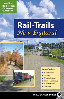
Mascott - Best rail trails. New England: more than 40 rail trails from Maine to Connecticut
Here you can read online Mascott - Best rail trails. New England: more than 40 rail trails from Maine to Connecticut full text of the book (entire story) in english for free. Download pdf and epub, get meaning, cover and reviews about this ebook. City: Guilford;Conn;New England, year: 2009, publisher: Falcon Guides, genre: Home and family. Description of the work, (preface) as well as reviews are available. Best literature library LitArk.com created for fans of good reading and offers a wide selection of genres:
Romance novel
Science fiction
Adventure
Detective
Science
History
Home and family
Prose
Art
Politics
Computer
Non-fiction
Religion
Business
Children
Humor
Choose a favorite category and find really read worthwhile books. Enjoy immersion in the world of imagination, feel the emotions of the characters or learn something new for yourself, make an fascinating discovery.

- Book:Best rail trails. New England: more than 40 rail trails from Maine to Connecticut
- Author:
- Publisher:Falcon Guides
- Genre:
- Year:2009
- City:Guilford;Conn;New England
- Rating:4 / 5
- Favourites:Add to favourites
- Your mark:
Best rail trails. New England: more than 40 rail trails from Maine to Connecticut: summary, description and annotation
We offer to read an annotation, description, summary or preface (depends on what the author of the book "Best rail trails. New England: more than 40 rail trails from Maine to Connecticut" wrote himself). If you haven't found the necessary information about the book — write in the comments, we will try to find it.
& nbsp;
Inside, readers will find: full trail profiles, including length, access points, difficulty rating, and surface type; detailed trail maps; at-a-glance icons for easy identification of rail trails that best suit ones interests; wheelchair accessibility; availability of parking, restrooms; places to eat along the trail; locations of ranger stations and visitors centers; and where to rent bikes, boats, skis, and other recreational equipment.
Mascott: author's other books
Who wrote Best rail trails. New England: more than 40 rail trails from Maine to Connecticut? Find out the surname, the name of the author of the book and a list of all author's works by series.

Best rail trails. New England: more than 40 rail trails from Maine to Connecticut — read online for free the complete book (whole text) full work
Below is the text of the book, divided by pages. System saving the place of the last page read, allows you to conveniently read the book "Best rail trails. New England: more than 40 rail trails from Maine to Connecticut" online for free, without having to search again every time where you left off. Put a bookmark, and you can go to the page where you finished reading at any time.
Font size:
Interval:
Bookmark:


Cynthia Mascott is the author of several other books including Enchanted Summer: A Romantic Guide to Cape Cod, Nantucket & Marthas Vineyard, and the Therapeutic Recreation Stress Management Primer. She has written numerous articles for newspapers and magazine and she is currently seeking representation for her novel.
This book could not have been completed without the companionship of Bruce Emerson, who shared in my delight in exploring the rail trails. I would like to thank my sister, Holly Mascott Nadler, for our various misadventures on the Cape and the stilling of our hearts at the Christmas Tree Shop. Terry Hansberry was a real trouper and helped me with all things New Hampshirian. I would also like to thank my cousin Deborah Mascott and her husband, Steven Malchman. Special thanks to Matt Rusteika for assisting me with the research for this edition of the book, and thanks to Eric Hess, Thomas E. Kilduff, Vienna Doctor, David Bonan, and Jack Olson. Finally I would like to thank all of the park rangers, district managers, and rail trail enthusiasts who helped me through the process of writing this book.
Connecticuts
Top Rail Trails
Panoramic views of the surrounding Connecticut hills and valleys characterize the Airline State Park Trail. Its most dramatic features are its two hidden viaducts, which offer expansive views of the scenery below.
Activities: 
Location: New London and Middlesex Counties
Length: 5.0 miles
Surface: Stone dust from Smith Street in East Hampton to Leonards Bridge Road in Lebanon
Wheelchair access: No
Difficulty: Moderate
Food: Limited eateries and convenience stores available along Route 16
Restrooms: Restrooms are available at various convenience stores and gas stations along Route 16.
Seasons: Year-round
Access and parking: From Route 2 (southeast of Hartford), take exit 16 and head south on Route 149 about 5 miles to Route 16 (Middletown Road). Turn right. Travel west on Route 16 for about 2 miles and turn right onto Comstock Bridge Road. Pass a covered bridge, turn right, and follow the road up the hill. At 1.2 miles is a set of yellow gates where a parking area can accommodate about a dozen cars. Parking is also available at Smith Street in East Hampton, Bull Hill and River Road in Colchester, and Route 85 in Hebrom. There is also room for a few cars at most road crossings.
Rentals: Scotts Cyclery, 1171 Main Street, Willimantic, CT; (860) 423-8889
Contact: Mike Reed, Department of Environmental Protection, 209 Hebron Road, Marlborough, CT 06334; (860) 295-9523

T he Airline State Park Trail has several nice features. It takes the traveler past rolling hills and valleys before opening up to expansive views atop the trails two viaducts left over from railroading days.
The Airline State Park Trail receives its name from the railroad that sped passengers between New York and Boston. The New York and Boston Railroad Company began developing the railroad line, but it was eventually completed by the Boston and New York Airline Railroad. Dozens of bridges and viaducts were constructed to span the rivers and valleys in central Connecticut. Two enormous viaducts, each more than 1,000 feet long, were built near East Hampton in the early 1870s. Eventually the viaducts could not support the weight of heavier trains, and early in the twentieth century they were completely filled in with sand. Much of the land is now in public ownership (the northern section was acquired in the 1960s and the southern section in the 1970s). Nearly 20.0 miles are now open, with 13.5 miles surfaced with stone dust.
To get to the trail from the parking lot, head to the left, navigating around some large boulders and a gate. The trail is densely wooded initially, but within 0.2 mile it begins to open up as it approaches the Lyman Viaduct. The viaduct spans about 1,100 feet, is more than 150 high, and is 50 feet wide.
The views of rolling hills and valleys to the left are breathtaking. The strip of rusted metal that emerges from the trail surface is an artifact of the railroad years. Take some time traversing the viaduct and try to visualize what it must have looked like at one time.
The next mile is wooded, with an occasional rocky cut on either side. These rocky areas are havens for wild ferns and moss. Several horse trails traverse the trail at this point.
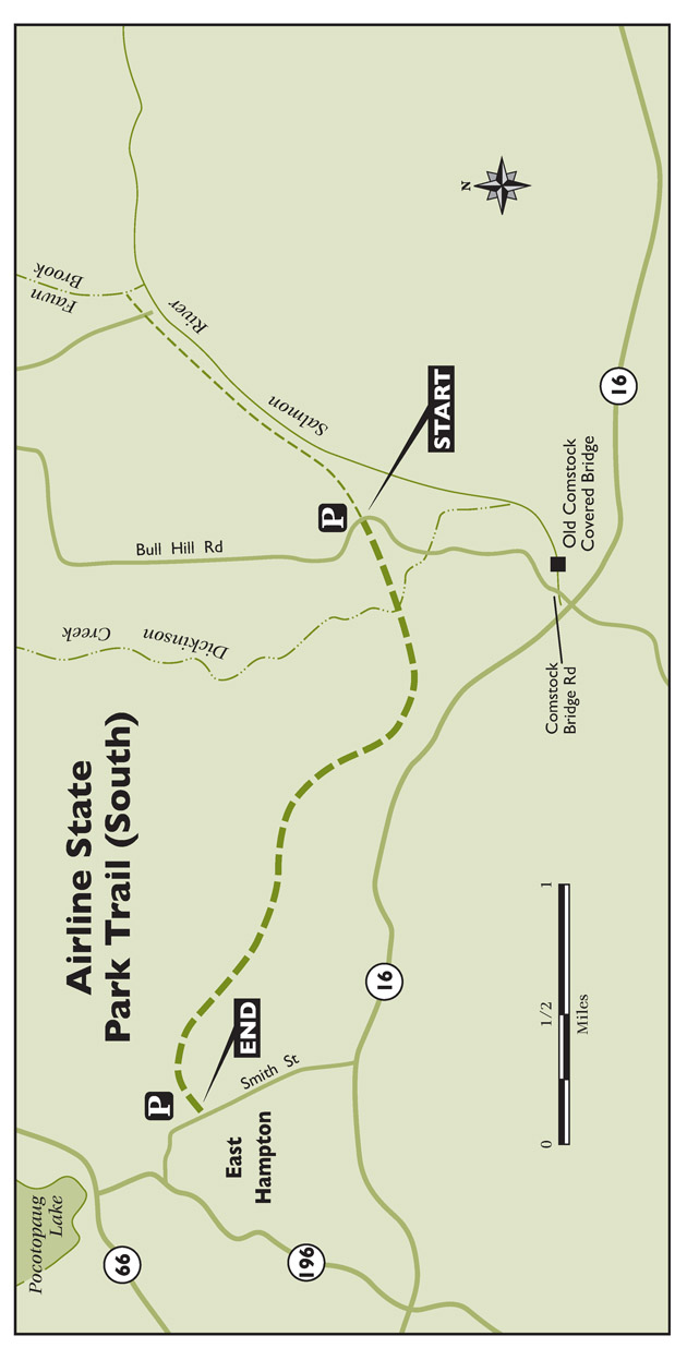
At 1.2 miles the trail cuts through an extensive rocky outcropping, blasted by the railroads developers to gain passage. Soon the trail reaches the Rapallo Viaduct. This one is longer (1,400 feet) and narrower than the first. You do not get the same sensation of towering above your surroundings on this viaduct, but it is still intriguing to cross.
On the opposite side of the viaduct, the trail continues for more than a mile to Smith Street. It passes wetlands on the right side while a small creek gurgles on the left. Just before Smith Street there is a pond on the right. Parking is available on the shores of the pond. While the trail continues into downtown East Hampton, it gets progressively narrower and more difficult to proceed. In addition, several bridges are not passable. The best bet is to turn around and enjoy the rolling hills and viaducts one more time.
If you have time, it is worth exploring the trail on the opposite side of the parking area. After backtracking to the parking area, you can continue east on the Airline Trail for nearly 13.0 miles.
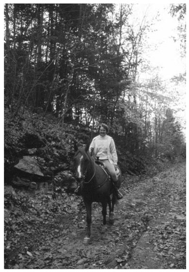
Equestrians make up one of the largest user groups of the Airline Trail.
The trail on this side is relatively wide and raised up on a ridge. After passing the first series of rocky outcroppings on the left, the trail passes a waterfall. The wooded trail offers a mix of coniferous and deciduous trees interspersed with walls of rock.
Soon you can hear the rush of the Salmon River below, which occasionally comes into view on the right. The trail skirts the edge of the Salmon River State Forest.
The Farmington Canal Trail is a work in progress. When completed the trail will extend for 84 miles, from New Haven, Connecticut, to Northampton, Massachusetts. The sections already opened are in varying stages of development.
Activities: 
Location: New Haven and Hartford Counties
Length: 40 miles with approximately 8 miles of paved asphalt in the areas featured
Surface: Varies from asphalt, crushed stone, and dirt
Wheelchair access: In New Haven, Hamden-Cheshire and the Southington sections
Font size:
Interval:
Bookmark:
Similar books «Best rail trails. New England: more than 40 rail trails from Maine to Connecticut»
Look at similar books to Best rail trails. New England: more than 40 rail trails from Maine to Connecticut. We have selected literature similar in name and meaning in the hope of providing readers with more options to find new, interesting, not yet read works.
Discussion, reviews of the book Best rail trails. New England: more than 40 rail trails from Maine to Connecticut and just readers' own opinions. Leave your comments, write what you think about the work, its meaning or the main characters. Specify what exactly you liked and what you didn't like, and why you think so.