Introduction
Californias rugged Big Sur coastline follows CA 1 (best known as Highway 1 or Route 1) as it heads south from the Carmel Highlands down to San Simeon and the Hearst Castle. Driving from the south, the route begins in San Luis Obispo County and continues north into Monterey County. This portion of Highway 1 is considered one of the most beautiful drives in the world, as the rocky coast rises from the Pacific Ocean, forming the towering hills and mountains of the Santa Lucia Range, home to the environmentally protected Ventana Wilderness and Los Padres National Forest. As you drive along the coast the scenery alternates between stunning ocean views, rolling hills and green pastures stretching along both sides of the highway. The landscape painter Francis McComas described it as the greatest meeting of land and water in the world. Highway 1 along the Big Sur coast has been named a National Scenic Byway and a California Scenic High way, designations reserved for roadways so distinctive, they are considered destinations unto themselves. This spectacular coastline attracts tourists from all over the world.
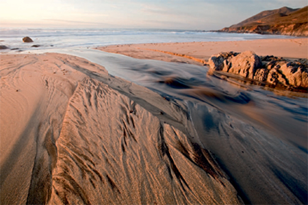
The Big Sur coast is dotted with numerous state parks, which provide access to hidden beaches and protected rocky coves. There are many pullouts along the ocean side of Highway 1, and often a short walk will lead to breathtaking vantage points that vary with the time of year, the tides, the weather, and the skies. For photographers, Big Sur is rich with possibilities. During the rainy winter months the hillsides turn emerald green, while in the summer and fall they are transformed into a rich golden color. In the late winter and early spring, March and April, a variety of wildflowers cover the hillsidespurple and yellow lupines, orange California poppies, and yellow mustard, to name a few. Fog often shrouds the shoreline during the summer months but typically gives way to clear skies in September and October, and bright, beautiful days are common in the winter. Winter storms bring dark clouds with much needed rainfall and often provide the most dramatic and interesting light for photography. Winter rains also bring mudslides, which can cause the closure of sections of High way 1 for days at a time.
Aside from the striking scenery, a wide variety of wildlife populates the Big Sur coast. In the winter months, California gray whales are clearly visible during their annual southern migration to protected coves along the Baja California peninsula in Mexico, where females give birth in February and March. Then the mothers and their young begin the long and treacherous trip north to Alaska, often staying very close to shore. On calm days it is easy to spot the spouting whales as they migrate up or down the coast. California condors are now a common sight in Big Sur, where the captive-breeding program that began many years ago has been so successful that released condors are once again breeding in the wild. Many other birds frequent the coastline; among my favorites are the brown pelicans that fly low across the water in long, undulating lines. During December elephant seals come ashore near San Simeon and are easily accessible for viewing and photographing. The elephant seals remain on the beach near San Simeon most of the year, but they are particularly interesting in December, when the large males battle for their harems and the females begin giving birth to the young weaners. Other sea mammals include harbor seals, sea lions, and sea otters, which can be observed from many locations along Highway 1.

Neptune Pool, Hearst Castle
The name Big Sur is from the Spanish el sur grande, the Big South. The designation refers both to the coastal region and the community of Big Sur, which is located along CA 1 in Monterey County about 25 miles south of Monterey. Because the community has no central location, travelers often find themselves wondering if they missed it. About 20 miles south of Monterey the highway turns inland, briefly following the Big Sur River and passing through redwood groves around Pfeiffer Big Sur State Park. Many of the communitys spectacular houses are obscured, well hidden up dirt roads behind locked gates. However, the community of Big Sur offers many excellent restaurants as well as a variety of options for lodging and camping. Big Sur also has excellent hiking trails that quickly lead into the backcountry and reveal an aspect of the Los Padres wilderness that can only be experienced on foot. A ranger station on the east side of Highway 1 in Big Sur has maps and helpful tips and advice from local rangers.
How to Use This Book
The winding and sometimes narrow two-lane highway along the Big Sur coastline offers sweeping seascapes and breathtaking coastal mountain views. At times the road dips low and close to the water; at other times it reaches heights of over 2,000 feet, providing towering panoramic views to the north and south.
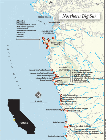
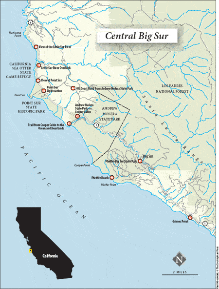
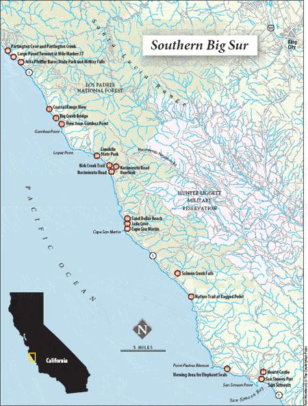
This book follows a north-to-south progression, beginning in Monterey County with Point Lobos as the northernmost photographic area and ending in San Luis Obispo County at San Simeon and Hearst Castle, about 90 miles to the south.
Highway 1 features small white mile markers on both sides of the highway, and I have used these to indicate locations for many of the sites described here. The first site covered is at about mile marker 68, with other locations following southward across the San Luis Obispo County line. Since the mile markers are on both sides of the highway, this guide can be easily followed whether youre driving north or south. I also give GPS coordinates (degrees, minutes, seconds) for most locations, which usually refer to the spot where I parked my car, not where I ultimately stopped to take photographs. This will allow for some variation in the images produced, since not everyone following this book will shoot from the exact same location. I have spent many days and evenings photographing along the Big Sur coastline, and in this book I share my favorite locations, some of which would be difficult to locate without assistance. You may decide on other vantage points or views. A short walk from many of the turnouts along the Big Sur coast will lead visitors to locations that will result in much stronger images than are possible just standing by the side of the road. It is always well worth the effort to scout out an optimal vantage point for your shots, and in Big Sur you usually do not have to go very far to find a different perspective resulting in a stronger image.

