Ray Hosler - Bay Area Bike Rides Deck
Here you can read online Ray Hosler - Bay Area Bike Rides Deck full text of the book (entire story) in english for free. Download pdf and epub, get meaning, cover and reviews about this ebook. year: 2020, publisher: Chronicle Books LLC, genre: Home and family. Description of the work, (preface) as well as reviews are available. Best literature library LitArk.com created for fans of good reading and offers a wide selection of genres:
Romance novel
Science fiction
Adventure
Detective
Science
History
Home and family
Prose
Art
Politics
Computer
Non-fiction
Religion
Business
Children
Humor
Choose a favorite category and find really read worthwhile books. Enjoy immersion in the world of imagination, feel the emotions of the characters or learn something new for yourself, make an fascinating discovery.

- Book:Bay Area Bike Rides Deck
- Author:
- Publisher:Chronicle Books LLC
- Genre:
- Year:2020
- Rating:3 / 5
- Favourites:Add to favourites
- Your mark:
Bay Area Bike Rides Deck: summary, description and annotation
We offer to read an annotation, description, summary or preface (depends on what the author of the book "Bay Area Bike Rides Deck" wrote himself). If you haven't found the necessary information about the book — write in the comments, we will try to find it.
Ray Hosler: author's other books
Who wrote Bay Area Bike Rides Deck? Find out the surname, the name of the author of the book and a list of all author's works by series.

Bay Area Bike Rides Deck — read online for free the complete book (whole text) full work
Below is the text of the book, divided by pages. System saving the place of the last page read, allows you to conveniently read the book "Bay Area Bike Rides Deck" online for free, without having to search again every time where you left off. Put a bookmark, and you can go to the page where you finished reading at any time.
Font size:
Interval:
Bookmark:
Copyright 2020 by Ray Hosler
Maps Copyright 2020 by Ray Hosler
All rights reserved. No part of this may be reproduced in any form without written permission from the publisher.
ISBN 978-1-4521-7888-2 (card deck)
ISBN 978-1-7972-0520-5 (epub, mobi)
Design by Maggie Edelman.
3D terrain was created using 3D Map Generator by Orange Box and Adobe Photoshop CC.
Chronicle Books LLC
680 Second Street
San Francisco, California 94107
www.chroniclebooks.com
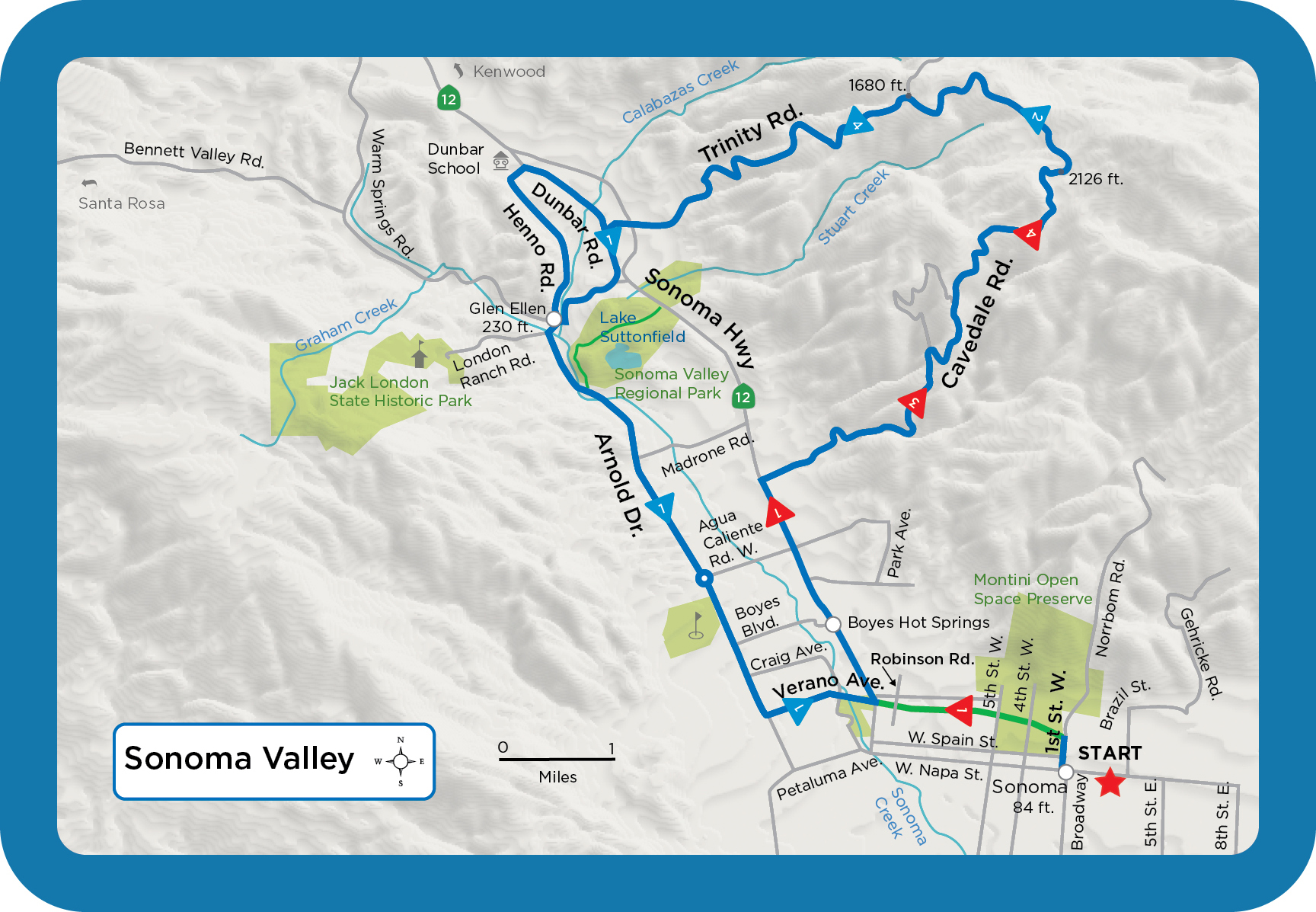
Cycling through Sonoma Valley, world-renowned for its colorful vineyards and wineries, comes with sour grapesheavy traffic year-round. In 2018, county supervisors approved a Highway 12 recreation trail from Sonoma to Santa Rosa. Experienced riders can still enjoy the valley by taking early morning rides, or heading to the hills. This 23-mile ride on Cavedale and Trinity roads climbs into the Mayacamas Mountains, where vistas of Sonoma Valley, hillside vineyards, and the San Francisco skyline await. The steep, narrow, and bumpy Cavedale Road averages 10 percent, with a few pitches of 16 percent. Trees that burned here in the October 2017 wildfires are growing back. The calamitous blaze blackened the hills and destroyed dozens of homes, but spared Sonoma Valley. Finish your ride by returning via Arnold Drive. For a short vineyard tour on quiet, flat country roads, make a loop starting from Glen Ellen. Closest freeway and city: Highway 101, Santa Rosa.
MILEAGE LOG > Start on First St. from the W. Spain St. intersection, going north. 0.18 Left onto Sonoma Bike Tr. 0.7 Cross Fifth St. at stop sign. 1.15 Right and merge onto Hwy. 12, Sonoma Hwy. 3.9 Right onto Cavedale Rd. 6.67 Climb eases for short distance. 6.9 Keep right. 9.0 Summit. 11.3 Left onto Trinity Rd. at stop sign and start descent. 14.35 Cross Hwy. 12 at stop sign. 14.7 Left onto Dunbar Rd. at stop sign. 15.2 Right onto Arnold Dr. at stop sign. 15.9 Glen Ellen. 19.4 Roundabout, circling right to stay on Arnold. 21.0 Left on Verano Ave. at traffic light. 21.9 Keep straight crossing Hwy. 12. 22.1 Right onto Robinson Rd. at stop sign. 22.3 Left onto bike path. 23.1 Right onto W. First St. 23.3 End ride. SHORT RIDE. Start in Glen Ellen on Arnold Dr., riding west on Warm Springs Rd. 0.06 Right onto Henno Rd. 1.88 Right onto Dunbar Rd. at stop sign. 3.2 Right onto Arnold Dr. at stop sign. 4.0 End ride.
Elevation: +/ 2430 ft
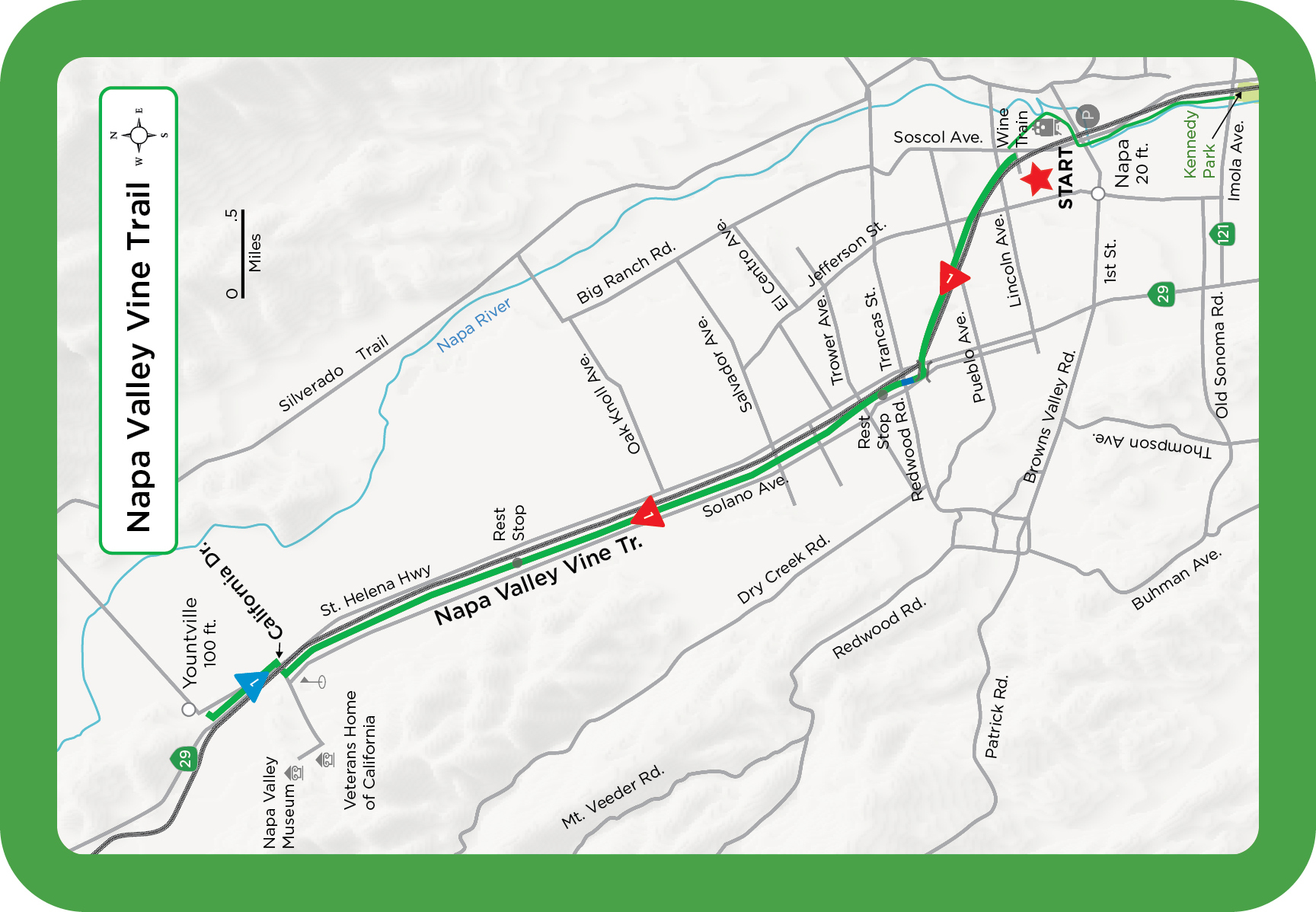
Napa Valley Vine Trail offers a 17-mile excursion through grape vineyards while staying off busy roads. A half-dozen wineries a short distance from the paved trail welcome cyclists. Silverado Trail is another favorite cycling route, but increased traffic generated by 4.7 million tourists and a burgeoning local population makes the Vine Trail the ideal route for carefree riding. Start in downtown Napa and head north on the flat trail, which parallels busy Highway 29 and the tracks of the Napa Valley Wine Train. The wine train offers daily trips between Napa and Yountville. Its the latest chapter in the areas long history of train travel. The trail has two rest stops with bathrooms and water. Closest freeway and city: Interstate 80, Napa.
MILEAGE LOG > Start on Vallejo St. and Soscol Ave., next to train tracks. (Trail extends south to Kennedy Park.) 0.21 Jackson St. 0.36 Lincoln Ave., traffic light. 0.51 Yajome St. 0.7 Central Ave. 0.9 Jefferson St., traffic light. 1.03 Pueblo Ave. 1.5 Cross California Blvd., train tracks, then bridge over Hwy. 29. 1.63 Turn left at junction and trail sign. 1.71 Right onto Solano Ave., bike lane. 1.9 Cross Redwood Road at traffic light and pick up trail next to Solano Ave. 2.66 Trower Ave., traffic light. 3.12 Wine Country Ave., traffic light. 3.4 Salvador Ave., traffic light. 4.4 Oak Knoll Ave. 5.25 Rest area. Water and portable toilet. 5.44 Washington St. 6.86 Hoffman Ln. 7.85 Right onto California Dr. at stop sign. Cross under Hwy. 29. 7.92 Left at crosswalk onto trail next to Hwy. 29 on-ramp. 8.7 Right onto Madison St. 8.78 Path ends at Washington St. Yountville Park on left. Water and bathrooms. 17.5 Return same way and end ride.
Elevation: +/ 160 ft
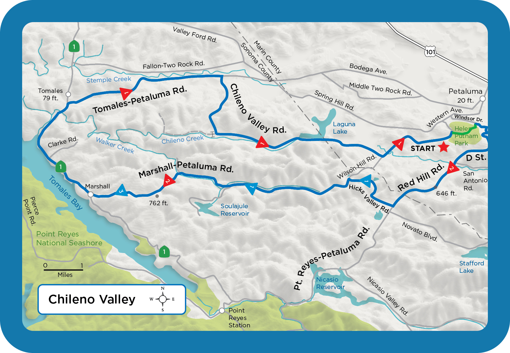
This relatively flat 47-mile ride starts at Helen Putnam Regional Park, just outside Petaluma, and goes through rolling, oak-covered hills on remote, lightly traveled roads where contented cows graze. Hicks Valley Road has the one-room Lincoln School, in service since 1872; attendance varies from 9 to 20 children. In the spring, Chileno Valley turns orange and yellow with California poppies and other wildflowers. Marshall-Petaluma Road, while not as well known as Chileno Valley Road, has some of the finest riding in the North Bay. The narrow, two-lane country road heads through the coastal range and sees almost no traffic as it winds through Verde Canyon alongside gently flowing creeks hidden by willows and the yellow-flowered Scotch broom. Dont miss downtown Petaluma, known for its Victorian buildings, where Francis Ford Coppola has filmed at least two movies. Closest freeway and city: Highway 101, Petaluma.
MILEAGE LOG > Start on the Helen Putnam Park paved recreation path next to the restrooms, and ride southeast. 0.4 Pond on left. 0.8 Summit. 1.1 Left onto Oxford Ct. where path ends. 1.2 Right onto Windsor Dr. at stop sign. 1.7 Right onto D St. at stop sign, starting climb. Becomes Red Hill Rd. 2.5 Summit. 6.1 Start climb. 7.4 Summit. 8.6 Right onto Hicks Valley Rd. at green sign. 9.5 Start climb. 10.2 Summit. 11.3 Left onto Marshall-Petaluma Rd. at T intersection. 17.7 Start climb. 19.4 Summit. Begin steep descent. 22.2 Right onto Hwy. 1 at stop sign. 27.8 Portable restroom at Keyes Creek fishing access. 29.1 Right onto Tomales-Petaluma Rd. Traffic can be heavy on weekends. 34.3 Right onto Chileno Valley Rd. 35.2 Start three- quarter-mile climb. 37.5 Road turns left. 43.8 Left at stop sign and T intersection, staying on Chileno Valley Rd.
Next pageFont size:
Interval:
Bookmark:
Similar books «Bay Area Bike Rides Deck»
Look at similar books to Bay Area Bike Rides Deck. We have selected literature similar in name and meaning in the hope of providing readers with more options to find new, interesting, not yet read works.
Discussion, reviews of the book Bay Area Bike Rides Deck and just readers' own opinions. Leave your comments, write what you think about the work, its meaning or the main characters. Specify what exactly you liked and what you didn't like, and why you think so.