Robert Hurst is the author of several FalconGuides and bicycling how-to books. He lives in Denver with his wife Christie, and daughter, Beatrice, both avid pedalers. He is currently waiting for the trails to dry up so he can get out there a few more times before winter settles in.
Thank you! Yes, you, the person who picked this book off the shelf. Maybe you even paid money for it. I could give you a big hug right now, but I wont because I totally respect your personal space. I thank you from afar.
Big thanks to David Legere at Falcon for this unforeseen and extremely welcome opportunity. It is greatly appreciated.
Thanks to Christie, who inexplicably continues to put up with me, and last but not least, thanks to Bea, who came along and showed me what easy rides are all about.
Bicycle Colorado
www.bicyclecolorado.org
Works effectively to make laws more bike-friendly
Bikes Together
www.bikestogether.org
Local nonprofit community bike shop. Works to transform the community through bicycle access and education. Two locations in Denver: 2825 Fairfax St. (303-393-1963) and 1060 Osage St. (720-403-8757).
Colorado Mountain Bike Association (COMBA)
www.comba.org
Trail builders and maintainers, advocacy
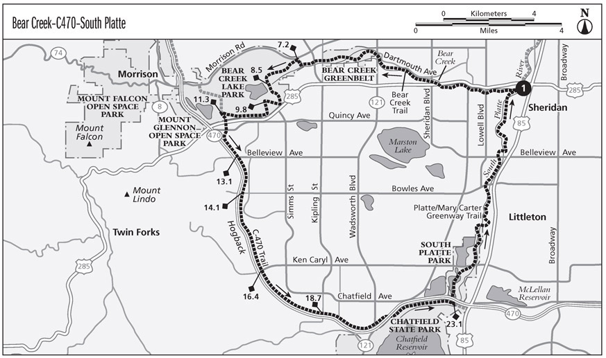
Although you might see a thousand cars speeding by within rock-throwing distance, you wont have to deal with very much traffic at all on this moderately hilly bike path loop around the southwestern quadrant of the Denver metro area.
Start: The intersection of the Bear Creek Trail and South Platte River/Mary Carter Greenway Trail, near Hampden and Santa Fe in Englewood
Distance: 30.5-mile loop
Approximate riding time: 23 hours
Best bike: Road
Terrain and surface type: Almost entirely on bike paths, but lumpy with several medium-sized hills
Highlights: Unbroken carless mileage, Bear Creek Lake Regional Park, the Mary Carter Greenway
Hazards: Other path users, including other bicyclists, runners, campers, and assorted wildlife. Not much interaction with motor vehicles, but get ready for a few tricky crossings of busy roads.
Other considerations: Ride can be lengthened to a half-century by starting from downtown and riding to the Bear Creek Trail via the South Platte River Trail.
Maps:DeLorme: Colorado Atlas & Gazetteer, page 40
Getting there: Located on major bike paths, this loop is readily accessible via bicycle from all angles. By car: Take South Santa Fe Drive to Hampden Avenue (aka US 285). Drive west on Hampden (285) to the first light. Turn left on South Platte River Drive, drive through the roundabout, and park in the movie theater lot on the south side near the bike paths. GPS: N39 39.099' / W105 00.488'
The Ride
Bicyclists in Denver can ride all day on wide concrete bike paths and encounter only a handful of road crossings. We can ride for 20, 30 miles at a stretch, right through the city center and through suburbs of all kinds, without interacting with the traffic grid one single time. It seems almost impossible in a car-crazed city in the middle of North America.
The Bear Creek Trail started as a mishmash of poorly executed trails but has been reworked into a very useful, fully separated dream facility. The BCT is twisty and narrow as it flows behind the working-class residences and strip malls of Englewood. Take special notice of the metal strips on the bridges. They are like ice when wet and are known to do a lot of damage. There is one actual road crossing (at South Lowell), but other than that, the BCT runs under the major roads all the way to the Fox Hollow Golf Course and Bear Creek Lake Regional Park, about 7 miles.
The route uses the very accommodating golf club road for a short tour, then rejoins more concrete path switchbacking up to the top of the only prominent hill in the vicinity (Mount Carbon). The BCT descends off the back side of the hill and twists into the green expanse below: Bear Creek Lake Park. This section of path that rollicks through the park is one of the most enjoyable and dramatic sections of multiuse path around. Come back sometime and ride the whole thing (see Bear Creek Lake Paved Loop on page 50.)
Headed south on the C-470 Trail, which loosely follows the highway, youll encounter a handful of road crossings. Enjoy a lot of downhill as the path swoops around the extreme southwest portion of the metro area. (Try this loop in the opposite direction and youll really feel these big rollers.) The last road crossing comes at around mile 18.7, which means the remaining 12 miles of the ride are unbroken, path-cruising miles. Not only that, but the path travels primarily through undeveloped areas.
Keep your eyes open along the southern section of the South Platte River Trail, where the trail is sandwiched between Eaglewatch Lake and Redtail Lake. As you might guess from the names of these lakes, there are wonderful wildlife viewing opportunities along this stretch. The trail itself is not particularly thrillingnearly straight and nearly flatas it chugs back to the starting point. How you feel about this section will depend largely on the wind direction at the time.
Miles and Directions
0.0 Start from the intersection of the Bear Creek Trail and South Platte River Trail/Mary Carter Greenway Trail and ride west on the Bear Creek Trail. There will be many intersections with minor paths and sidewalks along the way.
1.4 Carefully cross South Lowell Boulevard and continue west. The path continues south of the bridge.
7.2 The trail ends at Fox Hollow Lane near the intersection with Morrison Road. Turn left onto Fox Hollow Lane here and begin riding west toward the golf club, on the road or adjacent path.
8.5 The road has curled back around and you are now pointed southeast. Jump off the road onto the Bear Creek Trail, which has reanimated on the right side of the road.
9.8 At the tip-top of the mesa (Mount Carbon), hang a sharp left onto a path that descends. Stay on the main path during the descent, ignoring all the little connectors.
11.3 Veer left, leaving the Bear Creek Trail and joining the C-470 Trail southbound.
12.2 Cross West Quincy Avenue and continue straight south momentarily on a residential street.
12.5 Rejoin the C-470 Trail headed south.
13.1 Cross West Belleview Avenue.
14.1 Cross West Bowles Avenue.
16.4 Cross Ken Caryl Avenue.
18.7 Cross South Kipling Parkway, headed due east at this point.
21.0 After crossing under Wadsworth Boulevard, the route goes through a tunnel beneath C-470. (Dont take the asphalt path that continues on the north side of the highway.)
21.2 Follow signs for the C-470 Trail eastbound.
23.1 Take the left fork hereoff the C-470 Trail and onto the South Platte River Trail/Mary Carter Greenway Trail.
23.2 The trail goes beneath the highway and passes next to a parking area and through a little roundabout. Continue north.
30.5 Cross the bridge and arrive back at the start.
Ride Information
LOCAL EVENTS/ATTRACTIONS
Bear Creek Lake Regional Park: Between Morrison Road, C-470, and US 285 in Lakewood; (303) 697-4766; www.ci.lakewood.co.us/bclp. Horseback riding, waterskiing, swimming, camping. Entering the park is free for bikes, but motor vehicle operators will pay a fee.


