Contents
Guide
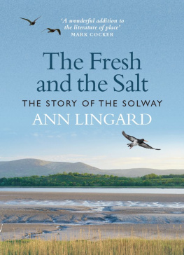
The Fresh and the Salt
OTHER WORKS BY ANN LINGARD
Non-fiction
Otmoor 2000 AD, Edited by Bruce Tremayne and Ann
Lackie (Lingard), The Otmoor Group, 2001
Lifetimes: Personal Stories of Participants in the Lothian Birth
Cohort Studies, CCACE, University of Edinburgh, 2014
Fiction
Figure in a Landscape, Headline Review (1996)
The Fiddlers Leg, Headline Review (1996)
Seaside Pleasures, Littoralis Press (2003)
Floating Stones, Online Originals (2003);
2nd edition Littoralis Press (2016)
The Embalmers Book of Recipes, Indepenpress Publishing (2008);
2nd edition Littoralis Press (2014)
The Leech and the Pearl, Littoralis Press (2018)

First published in 2020 by
Birlinn Limited
West Newington House
10 Newington Road
Edinburgh
EH9 1QS
Copyright Ann Lingard 2020
ISBN 978 1 78885 345 3
The right of Ann Lingard to be identified as Author of this work has been asserted by her in accordance with the Copyright, Designs and Patents Act 1988. All rights reserved. No part of this publication may be reproduced in any form or by any means without permission from the publisher.
British Library Cataloguing in Publication Data A catalogue record for this book is available from the British Library. Designed and typeset by Biblichor, Edinburgh

Typeset by Biblichor Ltd, Edinburgh
Printed and bound by Clays Ltd, Elcograf, S.p.A
Brown clouds are blown against the bright fells
Like celtic psalms from drowned western isles.
The slow rain falls like memory
And floods the becks and flows to the sea,
And there on the coast of Cumberland mingle
The fresh and the salt, the cinders and the shingle.
From Norman Nicholsons Five Rivers (1944)
Contents
List of Plates
Looking north across the Solway to Criffel and Scotland
Bowness Common, looking south to the Lake District fells
Sun and snow showers
Robin Rigg windfarm
A spadeful of burrows of the mudshrimp, Corophium
A heron by Hanging Stone
Dog-whelks, Nucella, laying eggs
Banded snails, Cepaea, on the dunes
The tubes of the honeycomb worm, Sabellaria
Cages and barnacle-encrusted posts of the former oyster-farm, Dubmill Point
St John the Evangelist church, Newton Arlosh
Holme Cultram Abbey
The Reading Room at Allonby
Ruins of Sweetheart Abbey
The cliffs at Rascarrel Bay
The submerged forest and peat-banks near Beckfoot
The clay dabbin house at RSPB Campfield
Clay loom-stones from the shores of Allonby and Beckfoot
Plaster diorama of Haig Pit at the Colliery Museum, Whitehaven
Low tide on the River Dee
The RNLIs former All-Weather Lifeboat Sir John Fisher
Celtica Hav and Zapadnyy at Silloth New Dock
The dock gates at the Port of Workington
High tide on a saltmarsh stint
The training walls and rails opposite Glen Caple, on the River Nith
Sundew at Bowness Common
Cotton-grass on Drumburgh Moss
Drowned birches along the former Solway Junction Railway, Bowness Common
Ruthwell Cross
Roman altars at Senhouse Museum, Maryport
New Red Sandstone, Fleswick Bay, St Bees
The remains of the viaduct on the embankment, Bowness
Granite wall at Kippford
The unconformity on the shore, Barrowmouth Bay
Cockle shells at Kippford
Starfish on the mussel-beds of Ellisons Scaur, off Beckfoot
Heston Island and disused stake-nets at Auchencairn Bay
Low tide at Moricambe Bay
Scallop dredgers moored at Kirkcudbright
The start of the Maryport Trawler Race
Haaf-netters, Bowness-on-Solway
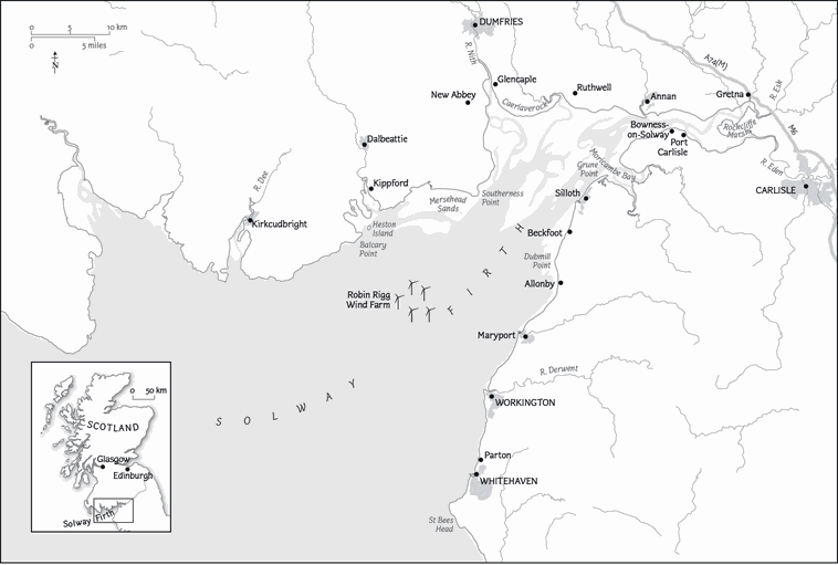
The Solway Firth
Introduction
We are flying slowly, low over Rockcliffe Marsh at the head of the Solway Firth. On each side of the vast saltmarsh the beds of the rivers Eden and Esk are knitted with patterns of light and dark that record their turbulent flow. The sunlight slanting through the clouds shifts shapes and colours across the land and water dark greens, silver-satin and bright blue. Mudflats are patches of ochre and burnt sienna, sandbanks are grey and gold, and water glimmers and flashes from creeks and pools, changing with the angle of our flight.
I can enjoy it now. I can even lean out over the side confident that my seatbelt will hold me and that I wont fall, tumbling and spinning, to disappear like a tossed pebble in the sticky mud that lies below. I can even speak again without my tongue clacking dryly against my palate. Earlier, at Carlisle Airport, I had been fitted with flying suit, scarf and helmet; hung my cameras lanyard round my neck; found my gloves (it would be cold); discarded my notebook (it would be windy). Andrew Lysserthat we could gain enough lift to leave the ground, but Andrews voice through my earphones told me, Well take off when the top rotor reaches two hundred revs per minute. As I looked out to my right, I saw a gap open between the shadow of the wheels and the runway and I realised we had become airborne, smoothly. I felt very exposed; there was nothing between me and outside. Andrew talked quietly to me over the radio his calm voice could persuade a potential suicide to step back from the brink and as he pointed out the recent alterations to the airport perimeter, a mansion belonging to someone well-known and, soon, the huge expanse of Carlisles railway marshalling yards, it became easier to enjoy the experience. We were seeing places which, screened at ground level, I hadnt even known existed. You see those buildings down there, with the trees all around? Thats a naturist colony! In chilly north-west Cumbria! By then I was nearly relaxed enough to laugh.
I had wanted this different perspective on the Solway because its not easy from shore level to appreciate the relationships between the bays and ports and rivers of the Firths two coasts. The Solway Firth is a crooked finger of water reaching far inland from the fist of the Irish Sea, apparently prising Scotland away from England: there is an invisible border down the midline of the Firth, yet the sea also unites the two countries as a means of passage. The word firth or more commonly in Victorian times, frith originates from a Norse word which also gave rise to fjord, and one definition is adamant that this differs from estuary. But at least twelve rivers, becks and burns flow into the Solway, and there is no question that the Upper Solway is a major estuary, into which open many smaller estuarine mouths. Even at its innermost tip, where it touches the Border at Gretna, the Firth experiences a tidal flow. Indeed, the Solway is famous for the range and speed of its tides, which during the biggest spring tides may have a range of nine to ten metres. In its entirety the Firth stretches from the Mull of Galloway in Scotland across to St Bees Head in Cumbria, but for many people, including me, the Firth means the Upper Solway, the land and sea to the east of a line between St Bees and the Mull of Ross west of Kirkcudbright (pronounced Kerr-

