1. KEEHA BEACH
A challenging, hate-it-or-love-it trek through dense, mud-prone coastal rainforest to a magically isolated stretch of exposed ocean beach.
Start : As you approach Bamfield, turn left onto South Bamfield Road and follow it a short distance. Park in a small area on the right-hand side of the road about 400 m before the trailhead (though you can drop off/pick up at the trailhead).
Difficulty : Some call this the gumboot trail because it has many extremely muddy sections. Be prepared to climb over fallen logs and roots. Psych yourself up to enjoy the obstacle course of a fairytale tangle of twisted trees or you may become frustrated by the slow going. Plan to take the better part of a day.

The surf can be dangerously large here, though in summer months it is usually low to moderate. (5)
- The first part of the trail, starting near some houses, is deceptively easy. Be prepared for wood to be slippery, however, particularly if you have Vibram soles (though waterproofs are probably the best footwear). At very high tides you will have to skirt through some trees behind a short section of shore that is normally the easier route. Before long you will come to the infamous mud, though at the end of a dry summer it can be minimal.
- About 1.6 km along the trail (it will seem much farther), you will come to a junction with a simple sign and usually a bit of flagging tape pointing to the right to Cape Beale, some 4.5 km down this trail. (See the Options section below.)
- Soon you get your first glimpses of Kichha Lake on your right (300 m). The trail approaches the shoreline of the 1-km-long lake primarily at its southern end. Dont expect a spot suitable for picnicking or swimming, though.
- Once you cross a boardwalk/floating bridge, the route begins a challenging ascent of the hill between you and the shore. The trail here is particularly prone to fallen logs. Once you have ascended about 30 m, the track descends; there are some ropes installed here to help when the going gets slippery. By now you will probably become aware of the roar of the surf, indicating the proximity of the beach.
- Only a few minutes are required to reach the beach from the bottom of the hill. Note the bear cache, a metal structure for storing food safely for those planning to spend the night here.
- You can explore the entire 1.7-km length of the beach. Probably the prettiest views (including a sea arch) and the best walking are along the southeast end, to your left. There is usually a small stream here, if you need water and are prepared to treat it. Look for cougar and bear tracks in the sand. Keep your eyes seaward, too, for migrating grey whales, especially in spring and fall when they come in close to the shore to feed.
- Return by the same route.
OPTIONS
- From the same trailhead, instead of going straight ahead at the signposted junction, turn right to hike to Tapaltos Beach along a muddy 1-km trail with scrambles over and under fallen trees. Tapaltos Bay itself is about 1 km long.
- At the south end of Tapaltos, a few fishing buoys in the trees mark the beginning of another trail, to Cape Beale lighthouse on a rocky bluff about 50 m above crashing waves. This trail too is muddy, and more strenuous than the first section to Tapaltos Bay, rising and descending over a fairly rocky hill. You will need to balance along logs, crawl under and over deadfall and keep an eye on your route by looking for flagging tape. There is no significant beach at Cape Beale, but there are great views from the lighthouse if the tide is low enough to get out to it over a small stretch of sand. Distance from the trailhead is 6 km.
10. MACAULAY POINT
An exposed, picturesquely bleak promontory, small beach, marina and breakwater. Historic bunkers and great views of the Olympic Mountains.
| 2 km | Easy |
| Starting elevation: near sea level | All seasons |
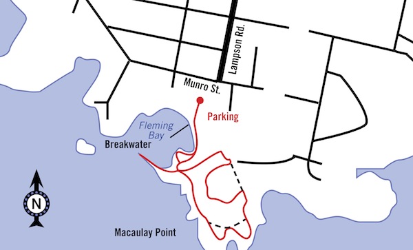
Start : From Highway 1 at a set of traffic lights 2 km north of central Victoria, turn onto Tillicum Road for 1.6 km. Take a slight jog left onto Craigflower Road for 100 m and then the first right onto Lampson Street for 2.3 km. Turn right onto Munro Street and almost immediately left where you see two signs, one for Buxton Green, Macaulay Point, the other for Fleming Beach boat ramp.
Difficulty : The paths are smooth and easy. If you leave the trail to go down to the small cove with rocky beach, walk along the breakwater or otherwise explore the shore off the trail, you will have to be a little careful with your footing. Be particularly cautious in winter, when the rocks can be slippery.
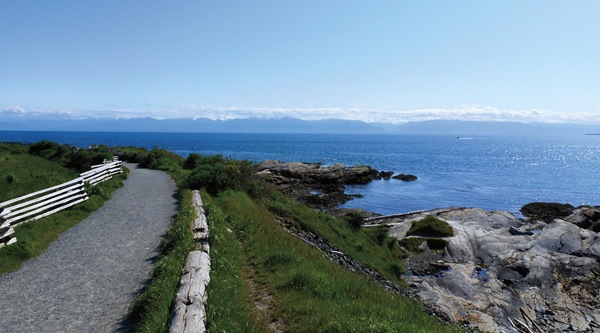
The central part of the main loop passes above two small coves that are attractive to explore, especially at low tide.
- From the parking lot by the marina, head left along the raised concrete walkway, which curves behind a small beach. If you want to include a visit to the beach on your trip here, plan to arrive when the tide is mostly in so that only the sugary dry sand of the upper beach is exposed. The low-tide rocks are largely jagged and slimy.
- Carry on along the edge of the grassy picnic area immediately beyond the beach. Oddly, the concrete pathway narrows to about 50 cm (20 in.) along the outer perimeter of this picnic area. If you are feeling sure-footed you can scramble up a bit of rock to rejoin the main trail. Otherwise, complete the circuit of the picnic area to link to the main trail.
- Follow the trail to the breakwater. Walk the length of the breakwater for interesting views and return to the shorefront trail.
- Branch right just beyond the orientation sign and map. Ignore each of the next four trails leading left in order to keep close to the shore. (These branches are only shortcuts along the base of two promontories.) After the first promontory and immediately behind an islet, you can scramble onto the shore, where there is a small beach with wave-rounded rocks. Along this section you will find your view changes significantly from looking across Esquimalt Harbour to the entrance to Victoria Harbour.
- The trail leads behind a small thicket of bushes to climb gently inland. When you come to a road-width concrete track, turn left and immediately left again to pass the first of two long-abandoned military bunkers. This is a reminder that in fact this whole area, militarized in the late 19th century, is leased from the Department of National Defence.
- Continue beneath high hedges to circle clockwise to the high point of the park and the second bunker. Turn left at the next two junctions.
- The last section of trail descends gently toward the shore and the starting point of the circuit walk. Return past the small harbour to the parking lot.
11. ISLAND VIEW REGIONAL PARK
A loop trail starting through a low, bushy area amongst dunes at the back of a narrow beachfront park and returning along the upper edge of a sandy, log-strewn shoreline. Lovely views of James Island and Sidney Island sand cliffs, DArcy Island and several American Gulf Islands.

