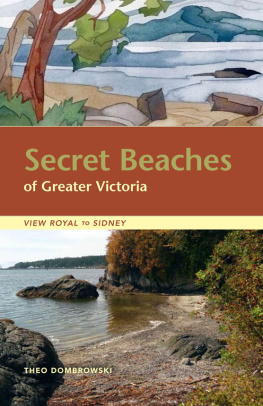
Theo Dombrowski - Secret Beaches of Greater Victoria. View Royal to Sidney
Here you can read online Theo Dombrowski - Secret Beaches of Greater Victoria. View Royal to Sidney full text of the book (entire story) in english for free. Download pdf and epub, get meaning, cover and reviews about this ebook. year: 2011, publisher: eBOUND Canada;Heritage House, genre: Home and family. Description of the work, (preface) as well as reviews are available. Best literature library LitArk.com created for fans of good reading and offers a wide selection of genres:
Romance novel
Science fiction
Adventure
Detective
Science
History
Home and family
Prose
Art
Politics
Computer
Non-fiction
Religion
Business
Children
Humor
Choose a favorite category and find really read worthwhile books. Enjoy immersion in the world of imagination, feel the emotions of the characters or learn something new for yourself, make an fascinating discovery.

- Book:Secret Beaches of Greater Victoria. View Royal to Sidney
- Author:
- Publisher:eBOUND Canada;Heritage House
- Genre:
- Year:2011
- Rating:4 / 5
- Favourites:Add to favourites
- Your mark:
Secret Beaches of Greater Victoria. View Royal to Sidney: summary, description and annotation
We offer to read an annotation, description, summary or preface (depends on what the author of the book "Secret Beaches of Greater Victoria. View Royal to Sidney" wrote himself). If you haven't found the necessary information about the book — write in the comments, we will try to find it.
Secret Beaches of Greater Victoria is a comprehensive review of nearly 100 beaches on the Saanich Peninsula and in the Greater Victoria area. While some of these are well used by people living nearby, many are virtually impossible to find without combing through official maps and back-road guides. Even the seemingly well-known shoreline from Oak Bay to Beacon Hill hides its own tiny pocket beaches and obscure coves.
Just as important as finding these spots is knowing what to expect. Thus each location is accompanied by detailed information that any beach explorer should know before setting out. Is the beach a few level steps from a vehicle or down a high, steep bank? Is the beach suitable for children? Large groups? Kayakers?
All of these questions and many more are answered in this book, which includes Theos hand-drawn maps, photographs and artwork.
- Watch...
Theo Dombrowski: author's other books
Who wrote Secret Beaches of Greater Victoria. View Royal to Sidney? Find out the surname, the name of the author of the book and a list of all author's works by series.


Secret Beaches of Greater Victoria. View Royal to Sidney — read online for free the complete book (whole text) full work
Below is the text of the book, divided by pages. System saving the place of the last page read, allows you to conveniently read the book "Secret Beaches of Greater Victoria. View Royal to Sidney" online for free, without having to search again every time where you left off. Put a bookmark, and you can go to the page where you finished reading at any time.
Font size:
Interval:
Bookmark:
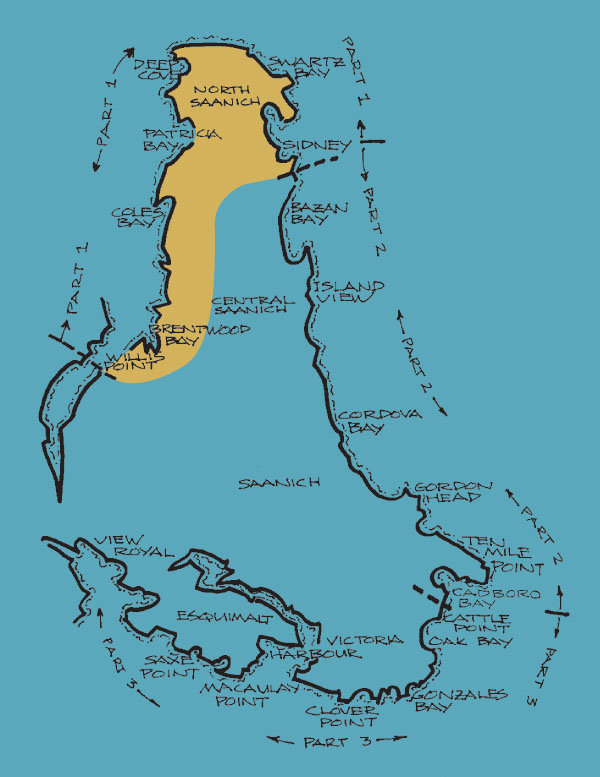
The huge chunk of land comprising the lower west side of Saanich Peninsula is still virtual wildernessand for a very good reason. While the rest of Saanich Peninsula is a largely hospitable area of wooded hills and valleys hosting farms and residential developments, this corner is a high range of rocky, wooded bluffs dropping steeply toward Saanich Inlet. The wonderful walking trails in this rugged corner await lovers of natural scenery, from Goldstream Provincial Park northward into Gowlland Tod Provincial Park.
Access to the shore along the west side of Saanich Peninsula begins with the northernmost of the many trails in Gowlland Tod Park. The beach explorer who starts here and moves north toward the tip of the peninsula will discover that although there are dozens of opportunities to get to the shore, the access routes come in distinct clumps. The tangled byways around Brentwood Bay provide one set of access points. After that, there are few opportunities to gain access to the shoreline until you approach the housing developments toward the tip of the peninsula and along its northern shore.
Fortunately, the shorefront access routes both in North Saanich and north of Sidney are generally well developed, well signpostedand well worth visiting. Those on the west coast of the peninsula provide the warmest swimming water, pretty pebbly coves of light-catching granite rock, lots of afternoon sunshine and great sunsets. The dozen or so access points north of Sidney provide wonderful island views, deep bays with marinas and bird sanctuaries and stretches of low-tide sand.
Throughout the whole area, the character of the beaches varies enormously with the level of the tide. Check the descriptions of individual beaches and consult your tide tables if you want to find just the beach to launch a kayak, take a warm and pleasant swim, explore tidal pools or run with your children barefoot over sand.
A long, forested walk to an isolated bluff and a tiny pebble beach
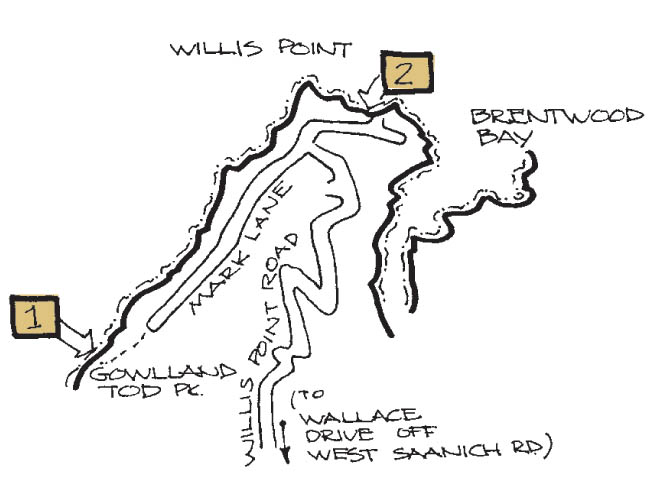
Location, signs and parking The access point at the end of Mark Lane within Gowlland Tod Provincial Park may win the prize for the most isolated spot in this book, particularly since the next entry describes the only other shore access for several kilometres. From West Saanich Road, turn off onto Wallace Drive and then follow Willis Point Road as it winds and weaves through many forested kilometres to the steep shores of Saanich Inlet. At the T-junction, turn left onto Mark Lane and follow the signs for GOWLLAND TOD PROVINCIAL PARK to the very end of the road. Be warned, though: there are several other access routes to different parts of this huge park and several enticing signs leading you to these different approaches. This is the only one that goes to the waters edge. You will have no problem parking in the large turnaround area without blocking anyones drive.
Path The path follows the route of a rough track once used by scuba divers and others. It is now used primarily by intrepid trekkers. To find the waters edge, walk 150 m down the wide track as it descends gradually toward the shore running parallel and visible through the trees. Once you are close to the water you will see a narrow path leading to a small, wooded knoll.
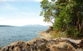
Beach If you really want a beachy bit of shore on which to flop languidly, try the tiny pebbly cove immediately to the left of the knoll. Since it is set well back into the trees, however, you may prefer to spend your time on the low, rounded rocky area under the arbutus and small firs. The shore drops off quickly here into the depths of the Squally ReachSaanich Inlet waters, so snorkellers will find it an intriguing spot to make a watery visit.
Suitability for children This is not the best spot for wobbly little creatures, but older children who are used to trekking with outdoorsy parents will enjoy this appealing beach. Low tide is most interesting for those who like bothering shore life; high tide is best for those who want to splash and be splashed.
Suitability for groups A wedding party or family reunion will not be thrilled by the long drive, the long walk and the limited shore area. Other, smaller groups who know what theyre facing will find that the easy parking, beautiful treed views and pleasant shore area are great for picnics and photos. Since the end of the road marks the beginning of the Mackenzie Bight Trail, some will use this approach to start a long walk. From here, trails lead along the shore of the inlet deep into the steep hills of the rest of the park.
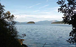
View This is the deepest into Saanich Inlet you can easily get from this east side of the inlet. Those who have driven up and down Malahat Drive for years will be intrigued by the views of the high, wooded hills of the Malahat not very far away across the inlet. The industrial scar of the former Bamberton cement works, now morphing into a residential area, will be a little less intriguing.
Winds, sun and shade The first half of the day is the shadiest, so choose afternoon if you wish to catch some rays to warm up after a dip or to sit in dappled shade under the trees on the promontory. The spot is fairly protected from most winds; when a strong westerly is kicking up a foamy fuss on the east side of Saanich Peninsula, you will be quite sheltered here, though some strong breezes occasionally funnel up and down the inlet.
Beachcombing You are on the edge here of a classic fjord sculpted by an ancient glacier. The more you go south, the more you experience the steep, rocky shore. It is possible to pick your way along this shore, especially at low tidewatching out for slippery rocksbut if you want to step out energetically, choose the park trails rather than the shoreline.
Seclusion Even on a warm summers day you can come to this spot expecting to see few people and be seen by few. The long drive is well worth the glorious seclusion you can usually find here.
A broad path to a tiny rocky cove, sometimes used by scuba divers, probably of most interest to kayakers
Location, signs and parking Willis Point, on which Mark Lane terminates, extends north into Saanich Inlet. After winding many kilometres along Willis Point Road from Wallace Road off West Saanich Road, you will reach a T-junction with Mark Lane. Turn right and follow Mark Lane almost to the end. No sign or house number exists to help you here, so simply look for a weedy, car-width track leading straight toward the water. There is lots of parking near the beginning of this track, unless you happen to arrive when divers are staggering to or from the shore.
Path One of the features that makes this spot usable for kayakersand diversis the easy path, gently sloping about 40 m to the shore. At the end of this path, a slight but awkward drop down to the confined space on the rocky shore makes access easier for divers than kayakers.
Beach You will find yourself on a rough bit of solid-rock shore with barely enough space to get one kayak at a time into the water. Few enticements beckon the beachgoer to this dark and enclosed bit of shore, other than its usefulness as access to the inlet. Since there is no other nearby launching spot for kayaks or canoes, those who would like to paddle into Saanich Inlet toward Goldstream might be happy to cope with the slight struggle of getting their craft into the water here.
Font size:
Interval:
Bookmark:
Similar books «Secret Beaches of Greater Victoria. View Royal to Sidney»
Look at similar books to Secret Beaches of Greater Victoria. View Royal to Sidney. We have selected literature similar in name and meaning in the hope of providing readers with more options to find new, interesting, not yet read works.
Discussion, reviews of the book Secret Beaches of Greater Victoria. View Royal to Sidney and just readers' own opinions. Leave your comments, write what you think about the work, its meaning or the main characters. Specify what exactly you liked and what you didn't like, and why you think so.