Copyright 2019 by Gerry Shea
First Revised and Updated Edition
Originally published in 2013 as Popular Day Hikes 3: Northern Okanagan
For information on purchasing bulk quantities of this book, or to obtain media excerpts or invite the author to speak at an event, please visit rmbooks.com and select the Contact tab.
RMB | Rocky Mountain Books Ltd.
rmbooks.com
facebook.com/rmbooks
Cataloguing data available from Library and Archives Canada
ISBN 9781771602457 (paperback)
ISBN 9781771602761 (electronic)
We would like to also take this opportunity to acknowledge the traditional territories upon which we live and work. In Calgary, Alberta, we acknowledge the Niitsitapi (Blackfoot) and the people of the Treaty 7 region in Southern Alberta, which includes the Siksika, the Piikuni, the Kainai, the Tsuutina and the Stoney Nakoda First Nations, including Chiniki, Bearpaw, and Wesley First Nations. The City of Calgary is also home to Mtis Nation of Alberta, Region III. In Victoria, British Columbia, we acknowledge the traditional territories of the Lkwungen (Esquimalt, and Songhees), Malahat, Pacheedaht, Scianew, TSou-ke and  SNE (Pauquachin, Tsartlip, Tsawout, Tseycum) peoples.
All rights reserved. No part of this publication may be reproduced, stored in a retrieval system, or transmitted in any form or by any means electronic, mechanical, audio recording, or otherwise without the written permission of the publisher or a photocopying licence from Access Copyright. Permissions and licensing contribute to a secure and vibrant book industry by helping to support writers and publishers through the purchase of authorized editions and excerpts. To obtain an official licence, please visit accesscopyright.ca or call 1-800-893-5777.
We acknowledge the financial support of the Government of Canada through the Canada Book Fund and the Canada Council for the Arts, and of the province of British Columbia through the British Columbia Arts Council and the Book Publishing Tax Credit.
Disclaimer
The actions described in this book may be considered inherently dangerous activities. Individuals undertake these activities at their own risk. The information put forth in this guide has been collected from a variety of sources and is not guaranteed to be completely accurate or reliable. Many conditions and some information may change owing to weather and numerous other factors beyond the control of the authors and publishers. Individuals or groups must determine the risks, use their own judgment, and take full responsibility for their actions. Do not depend on any information found in this book for your own personal safety. Your safety depends on your own good judgment based on your skills, education, and experience.
It is up to the users of this guidebook to acquire the necessary skills for safe experiences and to exercise caution in potentially hazardous areas. The authors and publishers of this guide accept no responsibility for your actions or the results that occur from anothers actions, choices, or judgments. If you have any doubt as to your safety or your ability to attempt anything described in this guidebook, do not attempt it.
Contents
Vernon
Lumby
North Shuswap
South Shuswap
Area Map
Introduction
About the North Okanagan Valley
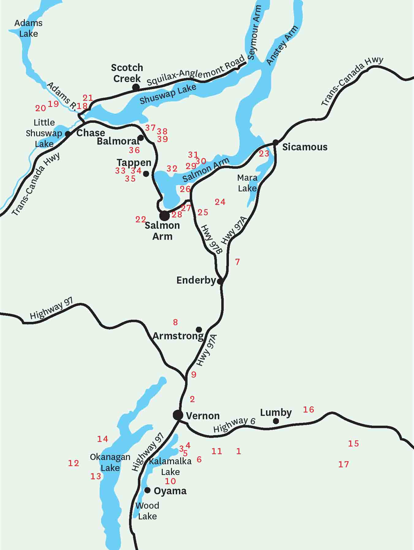
Stretching north to south in south-central British Columbia, the Okanagan Valley is almost 200 km long, with an average width of 20 km. Lying between the Cascade and Columbia mountain ranges, the North Okanagan Valley extends from Vernon to the Shuswap, including Salmon Arm, Sicamous and Scotch Creek. In this region, the Monashee Mountains are the prominent subrange of the Columbia Mountains.
Known for its climate, and enjoying consequent popularity as a summer playground, the region has lakes that are plentiful and large, characterized by an oblong shape which is generally the result of glacial advancement and retreat. This same glacial activity has created exceedingly deep lakes, with Adams Lake being the second deepest in British Columbia (the deepest being Quesnel Lake).
The soil of the North Okanagan is mainly a mixture of sand, silt and gravel, resulting in fertile land for farming. With annual precipitation of only 410 mm, and average summer temperatures of 27.3C with 304 days of sunshine, the Okanagan Valley is the richest, most diverse and productive agricultural zone in British Columbia after the Fraser Valley. Winters are mild, and although the snow can fall with ferocity, it doesnt stay for long, so spring in the lowlands of the valley arrives early. This usually allows for a relatively timely start to the hiking season.
Classified as a semi-arid region with sparse forests and open grasslands, the North Okanagan has plentiful hiking and backpacking routes. There are dozens of parks and recreational areas and just as many provincial parks, providing ample trails with incredible views. The hills are rolling mounds with countless ridges and modest peaks. This zone is truly a day hikers dream.
Fruit trees are not native to the Okanagan, although they are one of the most abundant species up and down the valley. The first fruit trees were planted by Hiram Smith near Osoyoos in the late 1850s. Today, crops include apple, peach, pear, plum, apricot and cherry. Indigenous forests are comprised mainly of varieties of hemlock and cedar. Intense summer heat, combined with dry air, readily burns off grasses on open hillsides by late June, leaving cactus and sagebrush to dominate the open hillsides.
Getting there
Highway 97 goes through the middle of the city of Vernon and can be accessed from Vancouver through the winding Crows-nest Highway (Highway 3), which departs from the town of Hope, heads east toward Princeton and empties into Highway 97 in the south Okanagan Valley. Travel north on Highway 97 to arrive at Vernon. Alternatively, take the Coquihalla Highway from Hope to Merritt, veering off of the Coquihalla onto Highway 97C. This will also take you to the South Okanagan. Drive north on Highway 97 to Vernon. From Vernon you can reach Armstrong and Enderby by driving farther north on Highway 97A.
To get to Vernon from Calgary, travel west on the Trans-Canada Highway and turn south at Sicamous onto Highway 97A. From Sicamous you will reach Enderby and Armstrong before arriving at Vernon.
Lumby is located 27 km east of Vernon by way of Highway 6.
Sicamous, Salmon Arm, Tappen, Balmoral and Sorrento are all situated on the Trans-Canada Highway, while the North Shuswap, Scotch Creek and Skimikin Lake Recreation Area are all accessed directly from the Trans-Canada. Refer to individual trail Start descriptions for precise directions.
Seasonal road closures
There are no planned seasonal highway closures through the Okanagan/Shuswap region, but inclement winter weather can create unscheduled temporary closures.
All gravel forest service roads (FSRs) are subject to late fall, winter and early spring closures, as many of them are not maintained during these times. During spring runoff, many FSRs can be closed for several weeks and some can even be washed away altogether. This has never been quite as evident as it became in the spring of 2012 when several gravel and paved roads were washed away and not repaired until mid- to late summer. Refer to the provincial website www.drivebc.ca for updates.



 SNE (Pauquachin, Tsartlip, Tsawout, Tseycum) peoples.