ACKNOWLEDGMENTS
In the course of research and the compilation of materials for this book, the authors drew upon the invaluable assistance and the picture collections of a number of individuals and organizations. Grateful acknowledgment is hereby made to the following: Robert F. Eisen; Robert C. Friedrich; the Greater Ridgewood Historical Society; George P. Miller; the Nassau County Museum Reference Library; Robert Presbrey; The Queens Borough Public Library, Long Island Division; The Queens Historical Society; Fred Rodriguez; the Suffolk County Historical Society; Edward B. Watson; Charles F. J. Young; and Ron Ziel.
WHERE TO Go AND WHAT TO Do ON LONG ISLAND, SCOPE. (0-486-42479-0)
THE BRIDGES OF NEW YORK, Sharon Reier. (0-486-41230-X)
NEW YORK CITY MUSEUM GUIDE, Candace Ward. (0-486-41000-5)
OLD ROCKAWAY, NEW YORK IN EARLY PHOTOGRAPHS, Vincent Seyfried and William Asadorian. (0-486-40668-7)
Paperbound unless otherwise indicated. Available at your book dealer, online at www.doverpublications.com, or by writing to Dept. 23, Dover Publications, Inc., 31 East 2nd Street, Mineola, NY 11501. For current price information or for free catalogs (please indicate field of interest), write to Dover Publications or log on to www.doverpublications.com and see every Dover book in print. Each year Dover publishes over 400 books on fine art, music, crafts and needlework, antiques, languages, literature, childrens books, chess, cookery, nature, anthropology, science, mathematics, and other areas. Manufactured in the U.S.A.
MASPETH
M aspeth is the site of the first European settlement in Queens County. In 1642 the Reverend Francis Doughty obtained a charter from the Dutch authorities in New Amsterdam for a tract of land at the head of Newtown Creek at what is now Maspeth, but the outbreak of an Indian war in 1643 scattered the colony. Settlement thereafter was by individuals who found their way from Bushwick in Brooklyn and from Long Island City shore and the Dutch Kills area. The present-day village of Maspeth grew up as a result of the Maspeth Avenue and Toll Bridge Company (1836) and the Newtown and Maspeth Plank Road Companys (1801) building through the area and creating trafficfarmers wagons and stagecoaches. In 1852 two farms were cut up into streets and building lots, opening the area from 59th Place to 69th Street and from 55th Drive south to the Plank Road, now Grand Avenue. Mount Olivet Cemetery bought up seventy-two acres in 1851. Maps show 56 houses in 1852, 135 in 1859 and 166 in 1873. Development thereafter was rapid: 1,449 residents in 1875 and 4,300 in 1898.
Maspeth today is a busy shopping center, with stores lining the length of Grand Avenue. Private houses predominate on the side streets but on the west end toward Newtown Creek there is much light industry. The population has traditionally been Polish and Italian and has remained relatively stable over the years.
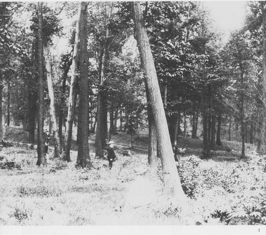
1. MAURICES WOODS, ca. 1900. Maurices Woods was the name given by Maspeth old-timers to a 72-acre forested tract bounded by what was to become Maurice Avenue, 66th Street, Jay Avenue and the Long Island Expressway. James Maurice, a very prominent New York lawyer, moved to Maspeth in 1840 and built a mansion on the south side of Maspeth Avenue about 800 feet west of the railroad tracks. In 1850 he was elected to the Assembly and in 1852 to Congress. In 1882 he donated the Woods to the Episcopal church as a site for a seminary, but the moving of the diocesan see to Garden City put an end to the project. For years the woods were enjoyed as a park and nature preserve by Maspethites, while houses grew up on all sides. Finally in October 1920 the church sold off the tract for development, and by 1922 streets and houses had wiped out all traces of the former green oasis. (Courtesy of The Queens Borough Public Library, Long Island Division.)
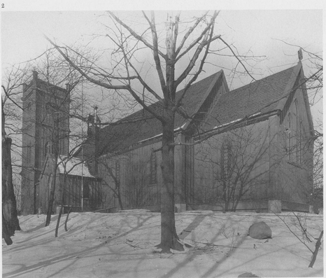
2. ST. SAVIOURS CHURCH, RUST STREET, ca. 1900. St. Saviours Protestant Episcopal Church is bounded by 57th Road, 57th Drive, 58th Street and Rust Street in a one-acre park all its own. In 1846 James Maurice donated the hilltop site and in 1847 the little wooden rural church was built, with nothing but farms surrounding it. The rapid development of Maspeth in the 1890s transformed it into a village church. By World War I days, the neighborhood had become industrial, with warehouses, gas stations and commercial plants. On December 21, 1970, three twelve-year-old boys set fire to the church, and the tower, vestibule and ceiling were destroyed. The congregation, aided by many gifts from near and far, rebuilt the church, and it continues today to minister to the community. (The Queens Borough Public Library.)
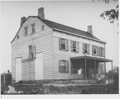
3. CLINTON MANSION, OLD TOWN DOCK ROAD, 1905. DeWitt Clintons historic mansion was bounded by 56th Drive, 56th Terrace (Old Town Dock Road), 56th Avenue and 58th Street. Built about 1725, the house was occupied by Sir Henry Clinton, the British commander, during the Revolution because it commanded a good view of the British fleet, which normally wintered in Newtown Creek, and was near the terminus of the British military road to the north shore.
DeWitt Clinton lived here on and off in the 1790s; he was Mayor of New York from 1803 to 1815 and Governor of New York State from 1817 to 1823 and from 1825 to 1828. In 1810, while living in Maspeth, Clinton was appointed a member of the Erie Canal Commission; in 1816 he headed the commission, and while governor in Albany worked to get the Erie Canal completed. It opened in October 1825. Much of the planning for New Yorks famous waterway was done in this house. In later years the mansion became a farmhouse, then a boardinghouse for farmhands, and finally burned down in 1933. (Photo by Charles Van Riper; Van Riper collection.)
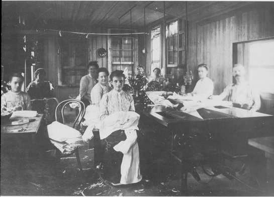
4. SEWING FACTORY, ca. 1905. Women workers sewing dresses in a shop. A motor shaft running under the worktables operates the sewing machines on top. Folding gas lamps hang on long pipes from the ceiling to within a foot of the tables for the use of each seamstress. ( Stines collection.)
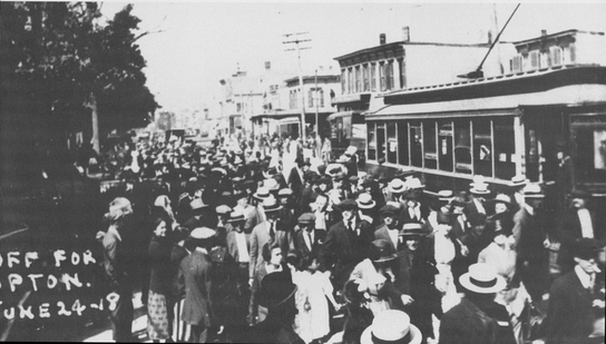
5. DRAFTEES BOARDING GRAND AVENUE TROLLEY, JUNE 24,1918. An unusual scenesoldiers drafted for World War I with their well-wishing relatives crowd about the Grand Avenue trolley car that is to transport them to the Brooklyn staging area and ultimately to Camp Upton for training. Mount Olivet Cemetery entrance is at the left. (The Queens Borough Public Library.)
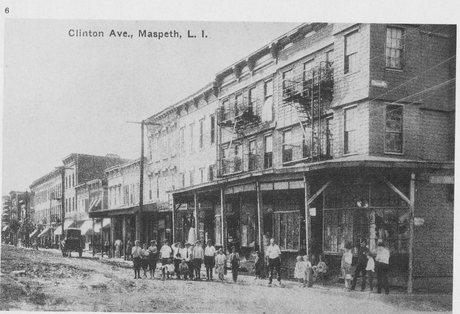
6. CLINTON AVENUE, ca. 1910. A Maspeth side street. Note the unpaved streets and the absence of curbs and street lights. (From a postcard; The Queens Borough Public Library.)

