

Published by The History Press
Charleston, SC 29403
www.historypress.net
Copyright 2010 by Ross Curry
All rights reserved
Front and back cover photo, top, by Mary Fairchild.
First published 2010
e-book edition 2011
ISBN 978.1.61423.264.3
Library of Congress Cataloging-in-Publication Data
Curry, Ross Milo, 1929-
Hidden history of the Wisconsin Dells area / Ross Curry.
p. cm.
print edition ISBN 978-1-60949-031-7
1. Wisconsin Dells Region (Wis.)--History--Anecdotes. 2. Wisconsin Dells Region (Wis.)--Social life and customs--Anecdotes. 3. Wisconsin Dells Region (Wis.)--Biography--Anecdotes. 4. Dells of the Wisconsin Region (Wis.)--History, Local--Anecdotes. I. Title.
F589.W8C874 2010
977.556--dc22
2010043798
Notice: The information in this book is true and complete to the best of our knowledge. It is offered without guarantee on the part of the author or The History Press. The author and The History Press disclaim all liability in connection with the use of this book.
All rights reserved. No part of this book may be reproduced or transmitted in any form whatsoever without prior written permission from the publisher except in the case of brief quotations embodied in critical articles and reviews.
This book is dedicated to my loving wife, Sylvia, without whose support and encouragement none of these writings would have been possible.
Preface
I was only sixteen years old when I got my first job as a writer, writing sports for the Wisconsin Dells Events in 1946. I have maintained some sort of connection ever since.
Since retirement in 1991, I have written a column that first started when I was still employed at the Events. It is mostly local history, although I sometimes get into a travelogue or similar subjects.
So when a History Press editor asked Kay James if there was anyone to do a book on local history, she referred him to me. After about six months of give and take, we came up with this book.
It does not contain a lot of well-known Kilbourn-Dells history stories because I have published them before in previous books and they wanted something all new. This is not quite all new, as these stories have appeared in the pages of the Wisconsin Dells Events in the past ten years, but it is the best I can do.
Some stories are omitted because I no longer have them in my computer; others dont quite fall under the topic of history.
We hope that future generations will enjoy the effort that went into this book to keep area history alive.
Special thanks to Kay James, Bill Brown, Bud Gussel, Mary Fairchild, Michael Goc and many others for their advice and to the many who contributed to these stories. It is all much appreciated.
Dells Area Is Home to Many Rock Formations
According to some geologists, Wisconsin has at various times been covered by vast ice sheets called glaciers. They claim glaciers gouged out the Great Lakes, with smaller ones digging out Green Bay and Lake Winnebago.
They also say the Wisconsin River ran through Devils Lake and the Baraboo River flowed into it at Baraboo until it was cut off by the advancing glaciers. This created a great lake that covered most of Juneau and Adams Counties.
The Wisconsin River finally broke through by cutting a new channel through the Dells, and the river took an end run around the eastern end of the Baraboo Bluffs before it once more resumed its journey southwest to the Mississippi River.
When things settled down, there was left a vast array of assorted rocks in the wake of the glacier. These were once islands in the lake, deposits that rode down on the glacier and formations left along the shore where the river cut its way through, such as Stand Rock.
People who live in the western states have been known to snicker at our array of rocks, saying that they have more rocks in their own backyard.
But others, with more than a cursory glance at our landscape, realize that Wisconsin rock formations are unique in the Midwest. No place between the Appalachians and the Black Hills is there the variety of rock formations found in south central and western Wisconsin.
While northern and eastern Wisconsin are relatively flat except for the range that runs through Rib Mountain, our landscape is dotted by such formations as Castle Rock, Mill Bluff, Observatory Hill, Petenwell Rock, Roche a Cri, Blue Mound, Rockbridge and many other places that I probably havent even seen.
Devils Lake is an impressive place to visit, with the so-called Devils Doorway high in the bluffs a favorite, if dangerous, place to have your picture taken.
I think the view from the top of Louis Bluff is just as great, if not more so, as the Devils Lake view, and it is just as dangerous and difficult to climb. I have made the climb about eleven times in my lifetime, with various friends and relatives and by myself. Im not sure I could do it anymore, as the last time I was tired for three weeks afterward. I am told that Tom McBride even rode his horse to the top once. The bluff is privately owned, and it is best to get permission before climbing.
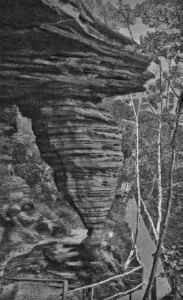
Hornets Nest. Once a favorite feature at the Stand Rock Landing, it collapsed during a sonic boom over three decades ago. Courtesy Eric Larson.
At the foot of Louis Bluff is the grave of Louis Dupless and his family. He was the first settler here and one of the first two or three settlers in all of Juneau County.
Within sight of the bluff is Stand Rock, probably the most famous rock in the Midwest, and numerous other rock formations nearby.
In the Lower Dells, we have Lone Rock, Hawks Bill and several Rocky Islands, one of which is Sugar Bowl Rock. There is also a rock along the railroad tracks where Curry Road went straight east to meet the tracks before I-90-94 cut the road off. We kids used to climb on it and watch the Hiawathas go by. We also called it Sugar Bowl Rock.
But my favorite was always the Hornets Nest. I never tired of gazing at it when I passed over the Stand Rock Amphitheater trail.
One summer afternoon about thirty years ago, my wife was returning from Spencer Lake Girls Camp with a car full of girls when she heard a tremendous crash. She thought she had hit something. She stopped the car, got out and looked around, but she saw no damage. We later decided that what had transpired appeared to have been a sonic boom.
At approximately the same time, the Hornets Nest rock formation collapsed and slid down into the valley at Stand Rock. Thus ended my favorite rock formation, but memories and pictures remain, and it will not be forgotten by those who once saw it.
Louis Bluff Was an Indian Lookout
Long before white men came up the Wisconsin River and named the rock formations at the Dells, the Wisconsin River was a superhighway for Native Americans.
The Dells happened to be right near the center of the Ho Chunk territory, so they often passed through. It also was about halfway between the Baraboo River junction and the Fox Portage nearby on the south and the Lemmonweir River junction on the north. So it was a common meeting place for a gathering of the Indian Nations.

