Best Hikes Madison, Wisconsin
Help Us Keep This Guide Up to Date
Every effort has been made by the author and editors to make this guide as accurate and useful as possible. However, many things can change after a guide is publishedtrails are rerouted, regulations change, facilities come under new management, and so forth.
We welcome your comments concerning your experiences with this guide and how you feel it could be improved and kept up to date. While we may not be able to respond to all comments and suggestions, well take them to heart, and well also make certain to share them with the author. Please send your comments and suggestions to the following address:
FalconGuides
Reader Response/Editorial Department
246 Goose Lane
Guilford, CT 06437
Or you may e-mail us at:
Thanks for your input, and happy trails!
Best Hikes Madison, Wisconsin
The Greatest Views, Scenery, and Adventures
Second Edition
Johnny Molloy

Thanks to all the people who have created, maintain, and hike the trails of the greater Madison area.

An imprint of The Rowman & Littlefield Publishing Group, Inc., 4501 Forbes Blvd., Lanham, MD 20706
Falcon and FalconGuides are registered trademarks and Make Adventure Your Story is a trademark of The Rowman & Littlefield Publishing Group, Inc.
Distributed by NATIONAL BOOK NETWORK
A previous edition of this book was published by FalconGuides in 2012.
Maps by Melissa Baker Rowman & Littlefield
All rights reserved . No part of this book may be reproduced in any form or by any electronic or mechanical means, including information storage and retrieval systems, without written permission from the publisher, except by a reviewer who may quote passages in a review.
British Library Cataloguing in Publication Information available
Library of Congress Cataloging-in-Publication Data is available
ISBN 978-1-4930-3146-7 (paperback)
ISBN 978-1-4930-3147-4 (e-book)
 The paper used in this publication meets the minimum requirements of American National Standard for Information SciencesPermanence of Paper for Printed Library Materials, ANSI/NISO Z39.48-1992.
The author and The Rowman & Littlefield Publishing Group, Inc., assume no liability for accidents happening to, or injuries sustained by, readers who engage in the activities described in this book.
Contents
Introduction
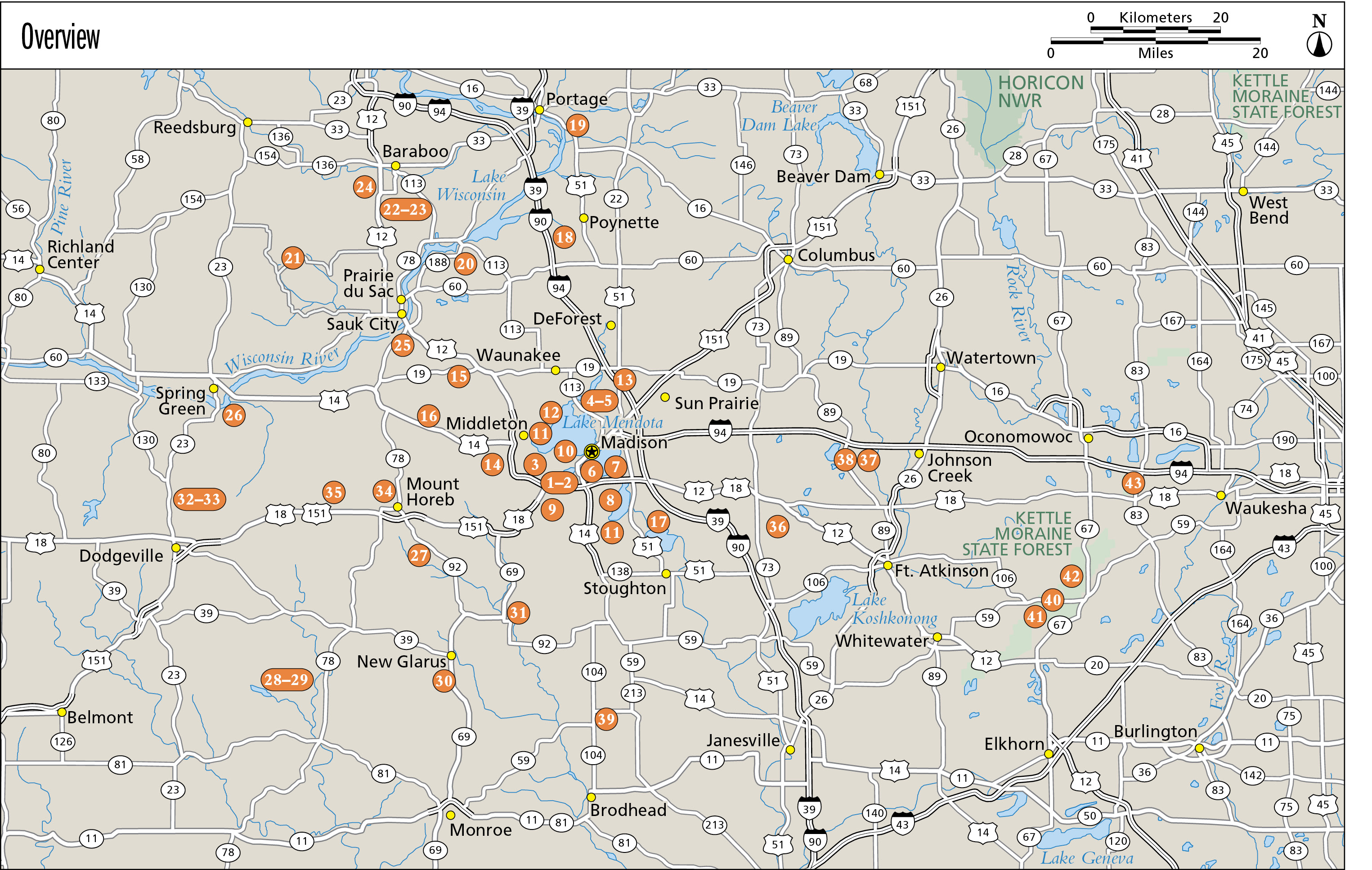
Madison is one of the great hiking towns in one of the great hiking states. A combination of scenic geologic features and a healthy stewardship for the natural world have led to a plethora of great hiking trails.
Perched at the western edge of a landscape defined by ancient glaciers, Madison is the second-largest city in Wisconsin. The state capital and home to the flagship campus of the University of Wisconsin, Madisons population in the city and surrounding area continues to grow, with many residents drawn to Mad Town by the abundant outdoor opportunities.
Numerous hiking trails offer a variety of terrain and natural features, including an assortment of trees and wildlife. Madison has a long history of conservation, reflected in an extensive system of parks and trails that snake through the city and into surrounding communities, providing an easy escape from the urban bustle. On these trails youll feel as if youve left civilization behind, other than the occasional sighting of the dome of the state capitol.
In the center of the city, near the university, Picnic Point takes hikers onto a narrow, sylvan spit of land jutting out into one of the five lakes that define the layout of Madison and surrounding areas. The hike has excellent views of the downtown skyline and a trek through a range of landscapes, including prairie and woodland. A short drive away, the universitys large arboretum spreads across a wide sweep of diverse topography.
Several parks sprinkled throughout the city honor local residents notable for conservation, such as Owen Conservation Park, with 3 miles of trails exploring a restored prairie and oak savanna, accessible from adjacent neighborhoods.
Beyond the city limits hiking options extend in all directions, with numerous parks and other hiking areas found among the vast sweep of farmland. Heading north past the high sandstone bluffs above the Wisconsin River, including a hike with breathtaking views at Gibraltar Rock State Natural Area, hikers are eventually brought to Devils Lake State Park, perhaps the crown jewel of the Wisconsin state park system. Here a pair of 500-foot bluffs soar over a picture-perfect lake, their slopes covered with quartzite boulders dating back hundreds of millions of years. Sandy soil and hardwood oak forest ring agricultural cropland in many rural areas.
To the west of Madison are hikes running through the Driftless Area, untouched by the glaciers that ground to a halt just outside the city, which thus have a more rugged landscape of steep ridges and deep valleys. It is a landscape of rolling prairie and savanna, with streams cutting through steep ridges and deep valleys. Numerous mounds are studded across the land. Governor Dodge State Park and Blue Mound State Park are two of the showpieces of the Driftless Area, with the former featuring a cave and trail that wind along the top of a ridge.
By contrast, the landscape at Kettle Moraine State Forest, east of Madison and just west of Milwaukee, bears the mark of the glaciers, especially in the shallow depressions and long ridges that give the forest its name. Kettle Moraine is another gem of a hiking area, with a wide selection of paths that will suit everyone from novices to more experienced trail walkers.
Natural and Human History
Madisons topography was defined by a glacier of the last ice age, dubbed the Wisconsin Glacial Episode, which flowed across the northern United States about 25,000 years ago. The last glacier reached its southernmost extent in Wisconsin about 15,000 years ago before it receded to the north. As a result, the effects of glaciation are more pronounced and visible in Wisconsin than perhaps anywhere else.
The ice sheet rolled over a wide swath of Wisconsin, carrying huge amounts of rock and depositing it on the landscape before stopping just a few miles southwest of Madison. The line of the last glacier can be seen in the route of the Ice Age Trail, which snakes across the state in a lazy S curve.
Reminders of the last glacier are seen in geologic features like kettles (depressions that often form small lakes) and moraines (low-lying ridges). Other remnants of glacial debris include small hills known as drumlins, including the rise the state capitol sits upon.
The glaciers laid the foundation for larger lakes as well, including the series of lakes along the Yahara River that define Madison: From north to south, they are Mendota, Monona, Waubesa, and Kegonsa, with Mendota and Monona bracketing the isthmus that is the site of downtown.
To the west of the isthmus is the university campus, while to the south is the university arboretum, which is located next to Lake Wingra, a smaller lake connected to the Yahara River chain by Wingra Creek, which flows along a city hiking trail before emptying into Lake Monona at Olin Park and Turville Park. The Yahara also flows by Cherokee Marsh and Token Creek, where hiking trails cut through the low-lying wetlands.
Next page










 The paper used in this publication meets the minimum requirements of American National Standard for Information SciencesPermanence of Paper for Printed Library Materials, ANSI/NISO Z39.48-1992.