Michael Ream - Best Hikes Near Madison: A Falcon Guide
Here you can read online Michael Ream - Best Hikes Near Madison: A Falcon Guide full text of the book (entire story) in english for free. Download pdf and epub, get meaning, cover and reviews about this ebook. year: 2012, publisher: Falcon Guides, genre: Home and family. Description of the work, (preface) as well as reviews are available. Best literature library LitArk.com created for fans of good reading and offers a wide selection of genres:
Romance novel
Science fiction
Adventure
Detective
Science
History
Home and family
Prose
Art
Politics
Computer
Non-fiction
Religion
Business
Children
Humor
Choose a favorite category and find really read worthwhile books. Enjoy immersion in the world of imagination, feel the emotions of the characters or learn something new for yourself, make an fascinating discovery.

- Book:Best Hikes Near Madison: A Falcon Guide
- Author:
- Publisher:Falcon Guides
- Genre:
- Year:2012
- Rating:5 / 5
- Favourites:Add to favourites
- Your mark:
Best Hikes Near Madison: A Falcon Guide: summary, description and annotation
We offer to read an annotation, description, summary or preface (depends on what the author of the book "Best Hikes Near Madison: A Falcon Guide" wrote himself). If you haven't found the necessary information about the book — write in the comments, we will try to find it.
Take a Hike!
Who says you have to travel far from home to go on a great hike?
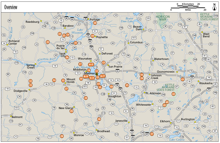
Here are forty-three of the best hikes, nearly all within an hours drive of Madison, Wisconsinfrom the Capital City State Trail to Devils Lake State Park. The hikes offer skyline views, a range of landscapes, and wildlife viewing opportunities. Whether youre in the mood for an easy nature walk or a day-long hike, this guide offers plenty to choose from:
Picnic Point
Pheasant Branch Conservancy
Gibraltar Rock
Blue Mound State Park
Pope Farm Park
Meadow Valley and Cave Trails
Each hike features full-color photos; a brief route description; thorough directions to the trailhead (GPS coordinates included); a detailed, full-color trail map; and at-a-glance information on distance and difficulty level, hiking time, canine compatibility, and fees and permits. Inside youll also find a Trail Finder that categorizes each hike (e.g., for attractions such as views, and if its suitable for families with kids); Green Tips; and information about local lore, points of interest, and the areas wildlife.
Michael Ream: author's other books
Who wrote Best Hikes Near Madison: A Falcon Guide? Find out the surname, the name of the author of the book and a list of all author's works by series.


Best Hikes Near Madison: A Falcon Guide — read online for free the complete book (whole text) full work
Below is the text of the book, divided by pages. System saving the place of the last page read, allows you to conveniently read the book "Best Hikes Near Madison: A Falcon Guide" online for free, without having to search again every time where you left off. Put a bookmark, and you can go to the page where you finished reading at any time.
Font size:
Interval:
Bookmark:

Best Hikes Near
Madison
Michael Ream


Copyright 2012 by Morris Book Publishing, LLC
ALL RIGHTS RESERVED. No part of this book may be reproduced or transmitted in any form by any means, electronic or mechanical, including photocopying and recording, or by any information storage and retrieval system, except as may be expressly permitted in writing from the publisher. Requests for permission should be addressed to Globe Pequot Press, Attn: Rights and Permissions Department, P.O. Box 480, Guilford, CT 06437.
FalconGuides is an imprint of Globe Pequot Press.
Falcon, FalconGuides, and Outfit Your Mind are registered trademarks of Morris Book Publishing, LLC.
TOPO! Explorer software and SuperQuad source maps courtesy of National Geographic Maps. For information about TOPO! Explorer, TOPO!, and Nat Geo Maps products, go to www.topo.com or www.natgeomaps.com.
All interior photos by Michael Ream.
Project editor: Heather Santiago
Layout artist: Maggie Peterson
Text design: Sheryl P. Kober
Maps by Mapping Specialists Ltd. Morris Book Publishing, LLC
Library of Congress Cataloging-in-Publication Data is available on file.
ISBN 978-1-4930-0587-1
The author and Globe Pequot Press assume no liability for accidents happening to, or injuries sustained by, readers who engage in the activities described in this book.
Contents
Acknowledgments
Thanks are due to all those who helped me find my way to and along the many excellent hikes in this book. The staffs of the City of Madison Parks and Dane County Parks were very helpful in providing maps and information on the multitude of trails found in parks sprinkled through both city and countryside. The City of Madison Traffic Engineering Division gave me the heads-up on the miles of paved path winding through the city, some of which I would not have known about otherwise. The Wisconsin Department of Natural Resources was a treasure trove of information on what to see at state parks throughout southern Wisconsin, with park rangers at Devils Lake, New Glarus Woods, and Governor Dodge State Parks especially helpful in pointing out sights to look for along their trails. Employees at these agencies all took time to answer questions and point me in the direction of some trails I had not initially considered, giving me the opportunity to experience some great hikes. Volunteers on many trails did the same, sharing their knowledge from cumulative years of experience.
I am indebted to Brad Herrick, ecologist at the University of Wisconsin Arboretum, for filling me in on the flora and fauna found in the diverse ecosystem that is the arboretum. Eric Sherman and the rest of the staff at the Ice Age Trail Alliance helped break down the long stretches of this national scenic trail into more manageable segments. Adam, Alexa, and the rest of the staff at Fontana Sports in Madison passed on tips about the gear and knowledge I might need for some of the trickier trails that made it into this book. Finally, thanks to all the helpful hikers I met along the trails, who shared their own personal knowledge of hikes and what to look for along the path. Their insights contributed greatly to enhancing the hikes with some hidden treasures and sights off the beaten path.
Introduction
Madison is one of the great hiking towns in one of the great hiking states. A combination of scenic geologic features and a healthy stewardship for the natural world have led to a plethora of great hiking trails.
Perched at the western edge of a landscape defined by ancient glaciers, Madison is the second largest city in Wisconsin. The state capital and home to the flagship campus of the University of Wisconsin, Madisons growing population of half a million in the city and surrounding area continues to grow, with many residents drawn to Mad Town by the abundant outdoor opportunities.
Numerous hiking and cycling trails offer a variety of terrain and natural features, including an assortment of trees and wildlife. Madison has a long history of conservation, reflected in an extensive system of parks and trails that snake through the city and into surrounding communities, providing an easy escape from the urban bustle. On these trails youll feel as if youve left civilization behind, other than the occasional sighting of the dome of the state capitol.
In the center of the city, near the university, Picnic Point takes hikers onto a narrow, sylvan spit of land jutting out into one of the five lakes that define the layout of Madison and surrounding areas. The hike has excellent views of the downtown skyline and a trek through a range of landscapes, including prairie and woodland. A short drive away, the universitys large arboretum spreads across a wide sweep of diverse topography.
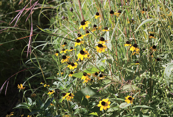
Flowers and native grasses line a path on the Curtis Prairie trail.
Several parks sprinkled throughout the city honor local residents notable for conservation, while the Southwest Path, popular with Madisons legions of cyclists, runs from the university football stadium to the edge of the city, where it hooks up with the Capital City State Trail, which gives hikers a choice of heading west into open countryside or east through wetlands and past old farms.
Beyond the city limits hiking options extend in all directions, with numerous parks and other hiking areas found among the vast sweep of farmland. Heading north past the high sandstone bluffs above the Wisconsin River, including a hike with breathtaking views at Gibraltar Rock State Natural Area, hikers are eventually brought to Devils Lake State Park, perhaps the crown jewel of the Wisconsin state park system. Here a pair of 500-foot bluffs soar over a picture-perfect lake, their slopes covered with quartzite boulders dating back hundreds of millions of years. Sandy soil and hardwood oak forest ring agricultural cropland in many rural areas.
To the west of Madison are hikes running through the Driftless Area, untouched by the glaciers that ground to a halt just outside the city, and thus have a more rugged landscape of steep ridges and deep valleys. It is a landscape of rolling prairie and savanna, with streams cutting through steep ridges and deep valleys. Numerous mounds are studded across the land. Governor Dodge State Park and Blue Mound State Park are two of the showpieces of the Driftless Area, with the former featuring a cave and trail that wind along the top of a ridge.
By contrast, the landscape at Kettle Moraine State Forest, east of Madison and just west of Milwaukee, bears the mark of the glaciers, especially in the shallow depressions and long ridges that give the forest its name. Kettle Moraine is another gem of a hiking area, with a wide selection of paths that will suit everyone from novices to more experienced trail walkers.
Natural and Human History
Madisons topography was defined by a glacier of the last ice age, dubbed the Wisconsin Glacial Episode, which flowed across the northern United States about 25,000 years ago. The last glacier reached its southernmost extent in Wisconsin about 15,000 years ago before it receded to the north. As a result, the effects of glaciation are more pronounced and visible in Wisconsin than perhaps anywhere else.
Font size:
Interval:
Bookmark:
Similar books «Best Hikes Near Madison: A Falcon Guide»
Look at similar books to Best Hikes Near Madison: A Falcon Guide. We have selected literature similar in name and meaning in the hope of providing readers with more options to find new, interesting, not yet read works.
Discussion, reviews of the book Best Hikes Near Madison: A Falcon Guide and just readers' own opinions. Leave your comments, write what you think about the work, its meaning or the main characters. Specify what exactly you liked and what you didn't like, and why you think so.