Lori has been a guest trail guide host on Park City TV and hosted Loris Mountain Report on KALL 700s Utah Outdoor radio show. Lori currently resides in Bountiful, Utah, where she is often out exploring the trails on foot, snowshoes, skis, and her bike.
In appreciation to all who helped me complete this second edition with updates and new hikes. Thank you to Mike Scalora for his help with my maps. Thank you to Sherry Holmes, William Barba, Robert Bunkhall, Marc Fletcher, Mike Scalora, Ethan Howell, and Matt Thalman for sharing their photographers eye and their beautiful photos. Thanks to Greg Hilbig at Draper City Parks and Recreation for his time and insights into the Corner Canyon area. Thanks to those who manage and care for the trails we all love so much.
Waterfall Canyon
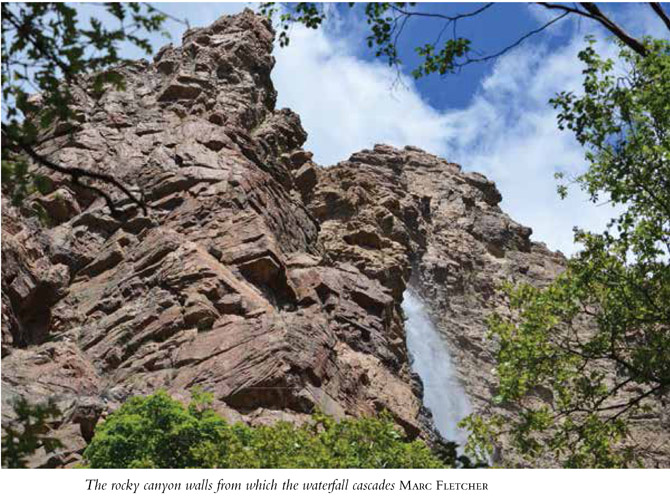
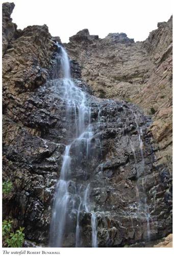
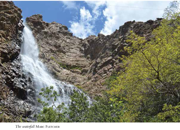
Short and strenuous, this poorly signed trail is a rugged scramble over rocks and roots to a dramatic 200-foot waterfall. The trail follows the stream that descends from the falls, and in spring and summer the waterfall can be gushing; wading may be necessary in spots. Fall hikers will find a much smaller waterfall and a trickling stream. Revered for its scenic view down into the valley as well as the luscious waterfall, this hike is often tackled by children as well as adults. A moderate fitness level is suggested.
Start: 29th Street trailhead
Distance: 2.6 miles out and back
Hiking time: About 1.5 hours
Difficulty: Strenuous due to elevation gain
Elevation gain: 1,010 feet
Trail surface: Sandy gravel, rock and boulders, bridge
Best season: Late spring through early fall
Other trail users: Bikers on lower portions of the trail
Canine compatibility: Leashed dogs permitted
Land status: Private land
Nearest town: Ogden
Fees and permits: No fees or permits required
Schedule: Trail closes 1 hour after sunset and opens 1 hour before sunrise
Maps: USGS Ogden; Weber Pathways trail map available by calling (801) 393-2304
Trail contacts: Weber Pathways, PO Box 972, Ogden 84402, (801) 393-2304, www.weberpathways.org; Land owner: Chris Peterson
Special considerations: Dont be tempted to climb up the rocks around the waterfall. It is illegal, and several hikers have fallen to their death.
Finding the trailhead: From Salt Lake City head north on I-15 to US 89 near Lagoon Amusement Park in Farmington (exit 324). Drive south on US 89 toward Ogden for 12.5 miles to Harrison Boulevard. Turn right onto Harrison Boulevard and continue to 30th Street. Turn right onto 30th Street, then turn left onto Polk and go to 29th Street. Turn right onto 29th Street and follow it to its end. Take a right into the trailhead. There is parking for forty cars but no restrooms. The trail is accessed from the south side of the parking lot and the trailhead shelter. This trailhead services a handful of trails, so make sure you start out on the correct one. GPS: N41 12.672' / W 111 55.909'
The Hike
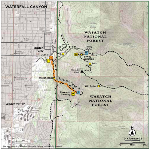
The trail up Waterfall Canyon is one of many that set out from the popular 29th Street trailhead shelter. The trail begins at the south side of the shelter and is the trail on the far left (north). Head up the hill. Within the first 0.1 mile, the stands of Gambel oak open to a view of Weber Valley to the west and the trail makes a horseshoe curve and climbs to the first intersection.
At 0.2 mile the trail intersects the Bonneville Shoreline Trail; a rather confusing wooden trail marker signals the various directions. Though the arrows on the sign are unclear, take the horseshoe curve and head right (south) up the trail. The doubletrack trail continues toward the canyon and forks near a set of old water tanks. Take the upper trail that continues to wind into the canyon.
The public has used this trail for more than 150 years, but the land on both sides of the trail is privately owned. Be sure to stay on the designated trails. Lined with sage, scrub oak, juniper, and rocks, the trail enters the canyon and the protection of the trees at 0.8 mile. Here the trail narrows to a rocky singletrack and begins to follow the stream up the canyon. Shortly you cross a wooden bridge.
A hundred feet after the bridge crossing, reach a T junction. In front of you is a forest alcove where rock training is done. Bright green sheriff storage boxes are secured in the area. The trail appears to curve easily to the right, but this branch leads away from Waterfall Canyon and out along the face of the mountain. Instead turn left and start the rocky climb up to the waterfall.
From this point the trail is a jumble of medium-size boulders and roots that must be climbed up and over to reach the top. The trail follows the stream, and at 1.2 miles a clearing on the south side of the stream, complete with a small cave, makes for an interesting picnic spot. The waterfall cascades just up the trail from here. During spring and early summer wading may be required in a few places as the trail crosses the stream. The 200-foot waterfall is a cooling experience as well as a fascinating sight. There are plenty of rocks available for sitting on and snacking while you enjoy the view. Return the way you came.
Miles and Directions
0.0 Start at the 29th Street trailhead.
0.2 Come to a trail intersection that crosses the Bonneville Shoreline Trail; turn right (south).
0.6 The trail forks by water tanks; take the upper trail.
0.75 The trail enters the canyon.
0.8 Come to a T junction; turn left and head farther into the canyon.
1.2 Reach a cave and clearing.
1.3 Arrive at the waterfall. Retrace your route to the trailhead.
2.6 Arrive back at the trailhead.
Hike Information
Local information: Ogden Nature Center, 966 West 12th St., Ogden 84404-5410; (801) 621-7595; open weekdays 9 a.m. to 5 p.m., Sat 9 a.m. to 4 p.m.
Organizations: Weber Pathways, PO Box 972, Ogden 84402; (801) 393-2304; www.weberpathways.org; e-mail: wp@weberpathways.org
Bonneville Shoreline Trail (BST). The BST runs down the Wasatch Range and when complete is planned to span from Logan in the north to Provo in the south. The BST intersects and often links several trails that cross it and ascend east into various Wasatch canyons. You will cross the BST on your way up Waterfall Canyon.


