In memory of my parents, Hiram and Annette Parent, who loved New Mexico.
FALCON GUIDES
An imprint of The Rowman & Littlefield Publishing Group, Inc.
4501 Forbes Blvd., Suite 200
Lanham, MD 20706
www.rowman.com
Falcon and FalconGuides are registered trademarks and Make Adventure Your Story is a trademark of The Rowman & Littlefield Publishing Group, Inc.
Distributed by NATIONAL BOOK NETWORK
Copyright 2018 The Rowman & Littlefield Publishing Group, Inc.
Photos Laurence Parent
A previous edition of this book was published by Falcon Publishing, Inc. in 1998 and 2010.
TOPO! Maps copyright 2018 National Geographic Partners, LLC. All Rights Reserved.
Maps The Rowman & Littlefield Publishing Group, Inc.
All photos by Laurence Parent unless otherwise noted
All rights reserved. No part of this book may be reproduced in any form or by any electronic or mechanical means, including information storage and retrieval systems, without written permission from the publisher, except by a reviewer who may quote passages in a review.
British Library Cataloguing-in-Publication Information available
Library of Congress Cataloging-in-Publication Data
Names: Parent, Laurence, author.
Title: Hiking New Mexico : a guide to the states greatest hiking adventures / Laurence Parent.
Description: Fourth edition. | Guilford, Conn. : FalconGuides, 2018. | Includes bibliographical references and index.
Identifiers: LCCN 2017054708 (print) | LCCN 2017056678 (ebook) | ISBN 9781493031108 (e-book) | ISBN 9781493031092 (pbk. : alk. paper)
Subjects: LCSH: HikingNew MexicoGuidebooks. | TrailsNew MexicoGuidebooks. | New MexicoGuidebooks.
Classification: LCC GV199.42.N6 (ebook) | LCC GV199.42.N6 P377 2018 (print) | DDC 796.5109789dc23
LC record available at https://lccn.loc.gov/2017054708
 The paper used in this publication meets the minimum requirements of American National Standard for Information SciencesPermanence of Paper for Printed Library Materials, ANSI/NISO Z39.48-1992.
Printed in the United States of America
The author and The Rowman & Littlefield Publishing Group, Inc., assume no liability for accidents happening to, or injuries sustained by, readers who engage in the activities described in this book.
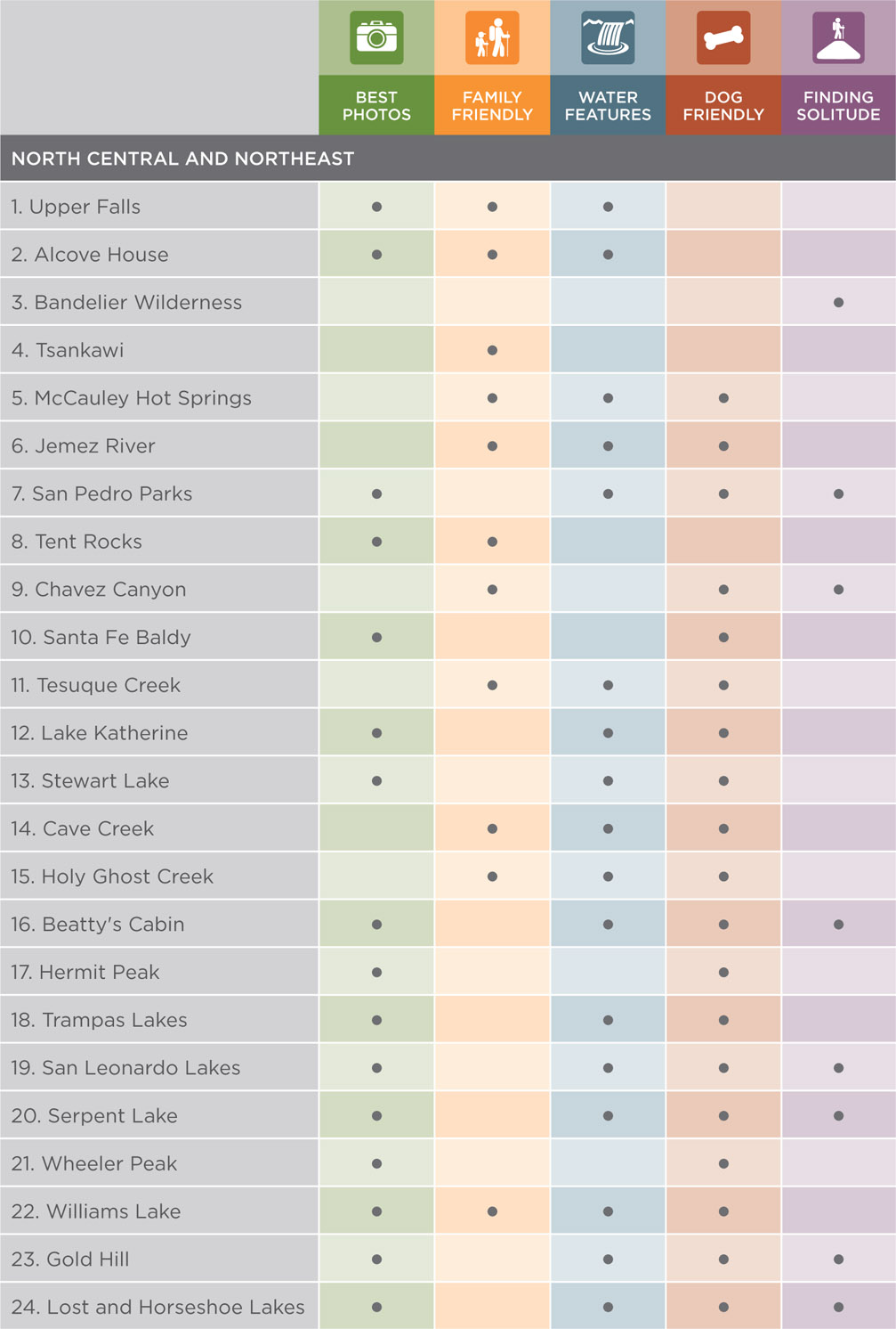
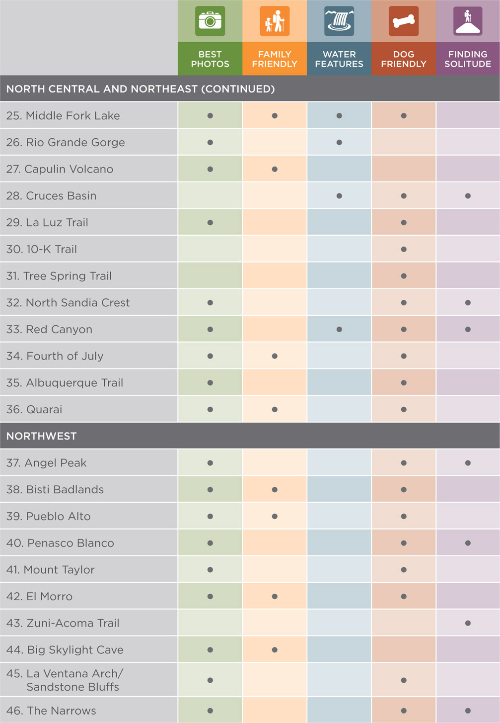
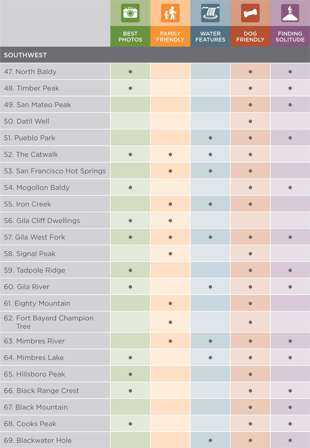
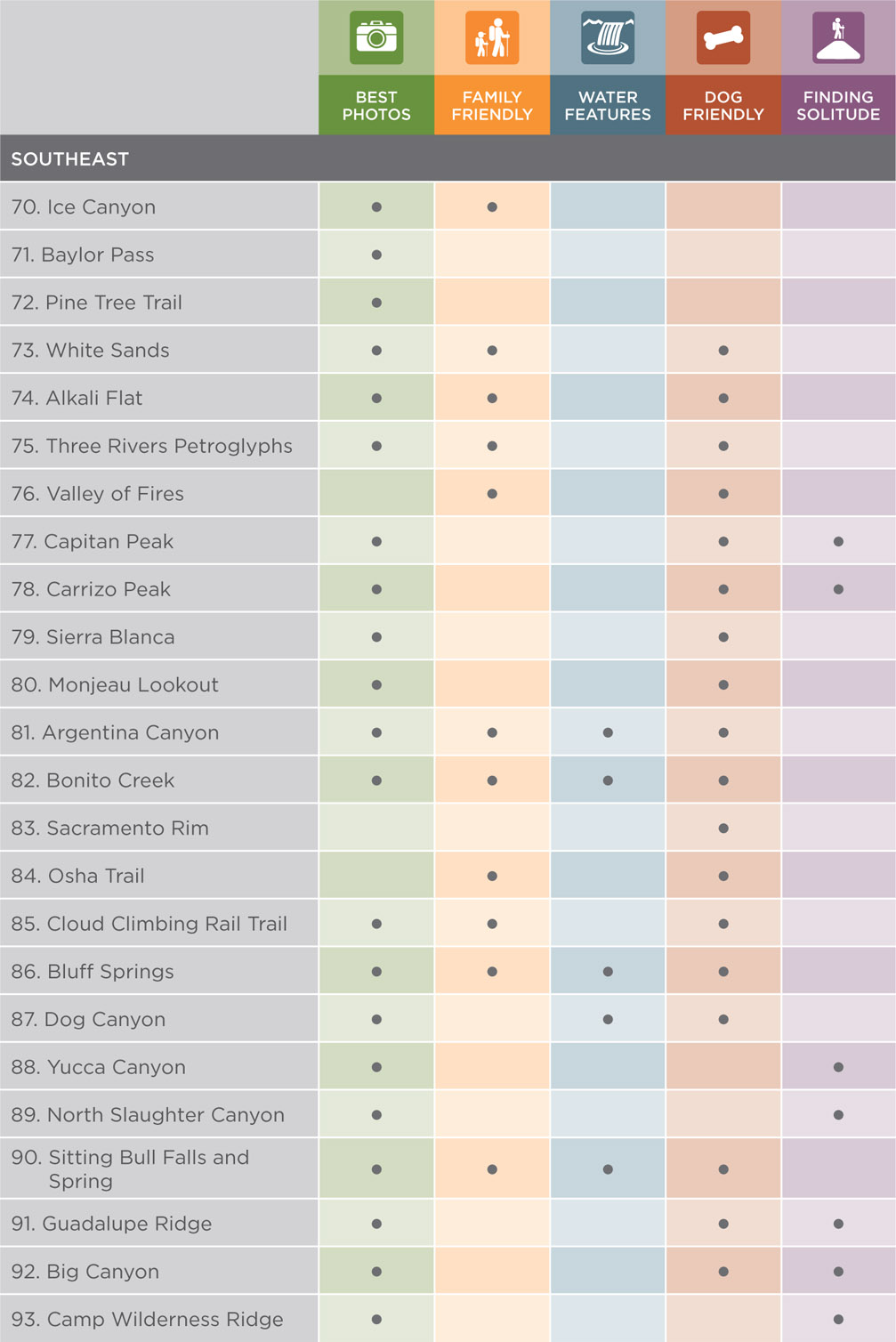
TRAIL FINDER
ACKNOWLEDGMENTS
Many people contributed to this book, more than can be listed here. Special thanks go to my wife Patricia, children Michelle and Jason, John Sanders, Tonya Sanders Hays, Pat Fischer, Mike Sauber, David Baxter, Larry Henderson, Steve and Carla Kennedy, Bob Reese, Dale Linenberger, Murt Sullivan, Nadine Luna, Gabriele and Jeff Teich, Jeff Fort, Mary Baxter, and Charmaine Smith for accompanying me on many hikes.
The following friends and family offered me their hospitality and logistical assistance with my hiking: my parents Hiram and Annette Parent, my sister Anne Fischer, Pat Fischer, David and Debbie Dozier, John and Adamina Morlock, Jack Shlachter, Cathy Bowman, and Nancy Wizner.
Steve and Peg Fleming, Robin and Kevin Soules, Melissa Forsythe, Elizabeth Moya, and Mike Small helped with photos. The REI store in Albuquerque graciously allowed me to use their extensive map collection. Many Forest Service, Park Service, and Bureau of Land Management (BLM) personnel endured numerous questions. Particularly helpful were Amy Hartell, Jim Apodaca, Lynette Brown, and Annette Smits of the Gila National Forest, Ron Henderson, formerly of the Gila National Forest, Phil Dano of the Cibola National Forest, and Jeremy Pritchett of the Lincoln National Forest. I would also like to thank Bill Blackard of the BLM and Cindy Ott-Jones, formerly of El Malpais National Monument.
Particular thanks go to Lora Hufton and Joanna Ruley- Garza, my office managers, for all their help with the revisions of the book.
MEET YOUR GUIDE
I was born and largely raised in New Mexico. After I received an engineering degree at the University of Texas at Austin, I practiced engineering for six years before becoming a full-time freelance photographer and writer specializing in landscape, travel, and nature subjects. My photos appear in calendars by Sierra Club, BrownTrout, Willow Creek Press, and many other publishers. My article and photo credits include National Geographic Traveler, Outside, Backpacker, Sierra, Newsweek, and the New York Times. I contribute regularly to regional publications such as New Mexico Magazine, Arizona Highways, Texas Highways, Texas Monthly, and Texas Parks & Wildlife. Other photography work includes posters, advertising, museum exhibits, postcards, and brochures.
I have completed more than forty books, including seven for FalconGuides: Hiking New Mexico, Hiking Texas, Hiking Big Bend National Park, Scenic Driving Texas, Scenic Driving New Mexico, Scenic Driving Wyoming, and Scenic Driving North Carolina. Other books include many large-format photo books for Graphic Arts Books, Western National Parks and Monuments Association, University of Texas Press, Texas A&M University Press, and Farcountry Press. I make my home in the Austin, Texas, area with my wife Patricia and two children.
My dad worked for the National Park Service, so I spent much of my childhood outdoors hiking, camping, and caving with my family. As an adult Ive continued to do so. Hiking is probably my favorite pastime, so Ive enjoyed writing and revising this guidebook to showcase many of my favorite hikes in New Mexico.
BEFORE YOU HIT THE TRAIL
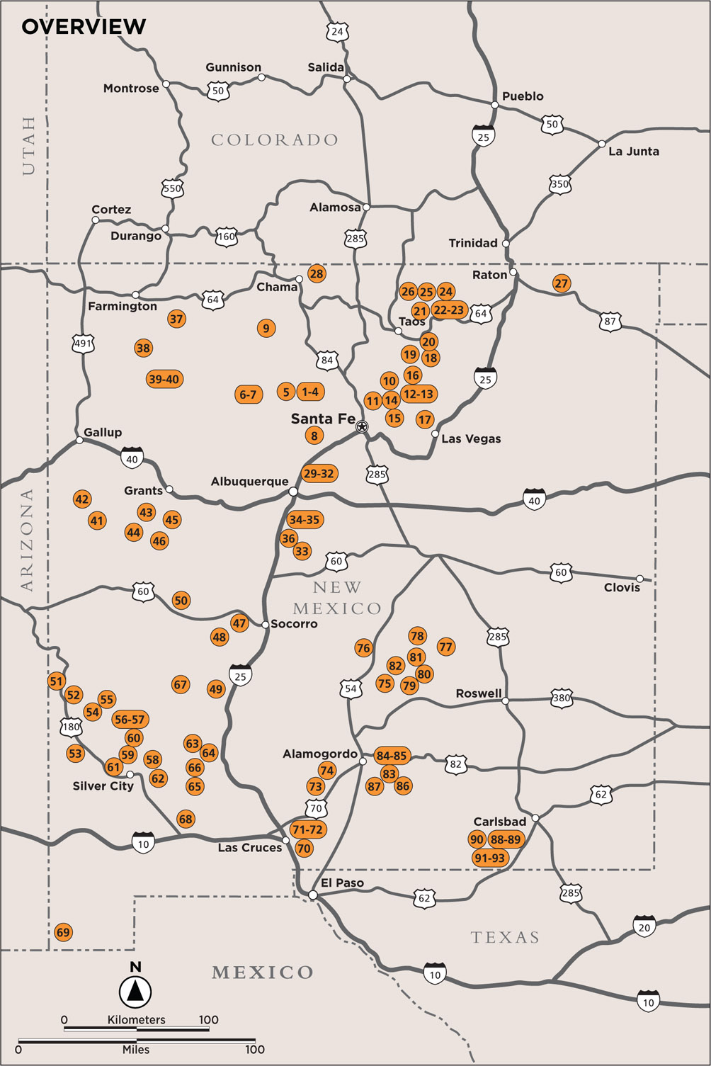
Hiking New Mexico describes ninety-three hikes scattered widely across the state. The map at the start of this book indicates their locations. Detailed trail maps accompany each hike. The map information was taken from USGS topo maps, national forest maps, BLM maps, national park maps, and others. Use the guidebooks maps in conjunction with the recommended government maps and map programs on GPS units. Each hike description includes the information you need to be well prepared for your adventure.
Why Go?
This section provides a brief description of each hike, often listing some of its highlights.
Start
This is a short summary of the starting location for the hike.
Elevation gain
This is often the most important factor in determining a hikes difficulty. The two numbers listed are the highest and lowest points reached on the hike. Often, but not always, the trailhead lies at the low point and the end lies at the highest point. With canyon hikes, the numbers are sometimes reversed. Many of the hikes have a fairly steady climb going out and a fairly steady downhill coming back. Some of the hikes have several ups and downs along the way, requiring more elevation gain and physical effort than the highest and lowest elevation numbers would seem to indicate. The Bandelier Wilderness hike is a notable example. The detailed hike descriptions mention multiple ups and downs.
Next page


 The paper used in this publication meets the minimum requirements of American National Standard for Information SciencesPermanence of Paper for Printed Library Materials, ANSI/NISO Z39.48-1992.


