About the Author
Bill Schneider has spent more than fifty years on the hiking trails of Montana. It started during college in the mid-1960s when he worked on a trail crew in Glacier National Park. He spent the 1970s publishing the Montana Outdoors magazine for the Montana Department of Fish, Wildlife and Parksand covering as many miles of trails as possible on weekends and holidays.
In 1979 Bill and his partner Mike Sample founded Falcon Publishing and released two guidebooks their first year. Since then, he has written 23 books and hundreds of magazine and newspaper articles on wildlife, outdoor recreation, and environmental issues.
Bill also taught classes on bicycling, backpacking, zero-impact camping, and hiking in bear country for the Yellowstone Institute, a nonprofit educational organization in Yellowstone National Park, for twelve years.
In 2000 Bill retired from his position as president of Falcon Publishing, which has grown into the premier publisher of outdoor recreation guidebooks with more than 800 titles in print. He spent the next ten years working as an online columnist, travel writer, and publishing consultant until finally discovering the true concept of retirement.
He now lives in Helena, Montana, with his wife, Marnie; works as little as possible; and stays focused on trying to hike, bicycle, and fish himself to death.
Books by Bill Schneider
Where the Grizzly Walks
Hiking Montana
The Dakota Image
The Yellowstone River
Best Hikes on the Continental Divide
The Flight of the Nez Perce
The Tree Giants
Hiking the Beartooths
Bear Aware: A Quick Reference Bear Country Survival Guide
Hiking Carlsbad Caverns & Guadalupe Mountains National Parks
Hiking Canyonlands and Arches National Parks
Best Easy Day Hikes Canyonlands & Arches
Best Easy Day Hikes Yellowstone
Hiking Yellowstone National Park
Backpacking Tips (coauthor)
Best Easy Day Hikes Absaroka-Beartooth Wilderness
Best Easy Day Hikes Grand Teton
Hiking Grand Teton National Park
Best Backpacking Vacations Northern Rockies
Hiking the Absaroka-Beartooth Wilderness
Where the Grizzly Walks (complete rewrite)
Bear Country Behavior (a Backpacker magazine book)
Hiking Montana Bozeman
For more information on Bill Schneiders books, go to www.billschneider.net.
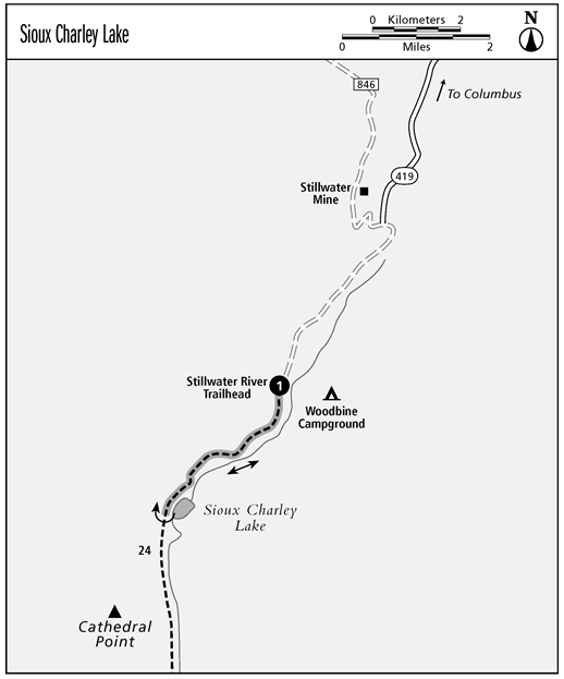
Sioux Charley Lake
A short, easy day hike along a wilderness river to a fish-filled mountain lake. The Stillwater River Trailhead is one of the most accessible and heavily used access points to the Beartooths.
Start: Stillwater River Trailhead
Distance: 6 miles out and back
Maps: USGS Cathedral Point; RMS Mount DouglasMount Wood; and at least 1 wilderness-wide map
Finding the trailhead: From I-90 at Columbus, drive 15 miles south on MT 78 to Absarokee. Continue south 2 miles, turn west onto the paved Nye Road (CR 419), and go through Fishtail and Nye. Stay on this road, which eventually ends at the trailhead, about 2 miles past the Stillwater Mine. Its about 42 miles southwest of Columbus. Plenty of parking; toilet; Woodbine Campground near the trailhead. GPS: 45.35082 N, 109.90331 W
The Hike
The trip into Sioux Charley Lake is one of the most popular day hikes in the Beartooths, so dont be surprised to see lots of people on the trail. From the trailhead its 3 miles to the lake, all on an easy, slightly uphill grade.
Soon after leaving the trailhead, the trail enters a narrow canyon where, right next to the trail, the river tumbles over a series of cascades and rapids. Many a hiker has paused here to wonder why this stream was ever named the still water.
After passing through the narrow canyon, the trail winds through a heavy forest all the way to Sioux Charley Lake. Now the reason behind the rivers name becomes clear. The lake is really just a large, slow-moving or still, section of the river. Farther upstream the river slows into several similar still-water stretches.
Look across the lake to the east to see the northernmost reaches of the dramatic forest fires of 1988. The Storm Creek Fire burned all the way from Yellowstone National Park down the Stillwater River drainage to Sioux Charley Lake, almost completely through the Beartooths.
Fishing
The Stillwater River can yield a lot of pan-size trout. There is a mixture of rainbows and Eastern brook trout (brookies), with an occasional cutthroat to be found along this route. Much of the slower water is dominated by brookies. Since brook trout tend to overpopulate (to the detriment of other species), please eat them and help out the cutts and rainbows. Catch and release doesnt improve the brookies sizeit only limits the amount of food available per fish. Besides, they taste great! Sioux Charley Lake is one of the best places to catch these tasty morsels, and the omnipresent brookies can provide dinner for many large parties.
Miles and Directions
| 0.0 | Start at Stillwater River Trailhead. |
| 3.0 | Sioux Charley Lake. |
| 6.0 | Arrive back at Stillwater River Trailhead. |
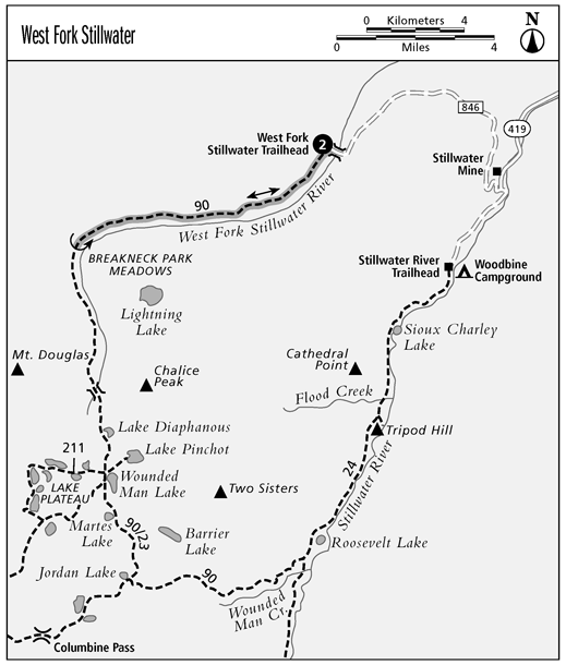
West Fork Stillwater
A great hike for hikers wanting to experience a remote wilderness river valley. Unlike the Stillwater River Trailhead, one of the most accessible and heavily used access points to the Beartooths, the West Fork Stillwater Trailhead gets very little use.
Start: West Fork Stillwater Trailhead
Distance: Up to 16 miles out and back
Maps: USGS Picket Pin Mountain and Tumble Mountain; RMS Mount DouglasMount Wood; and at least 1 wilderness-wide map
Finding the trailhead: From I-90 at Columbus, drive 15 miles south on MT 78 to Absarokee. Continue south from town about 2 miles and turn right onto Nye Road (CR 419). Drive about 25 miles southwest, through Nye, to the Stillwater Mine (which is about 2 miles before the Stillwater River Trailhead and Woodbine Campground at roads end). Immediately after the mine, turn right (west) onto FR 846 (on the map) or FR 2846 (on the sign) at a well-marked intersection. From here its a long, bumpy 8.6 miles to the trailhead. Initial Creek Campground is about a mile before the end of the road. Drive past the campground to the very end of the road. Ample parking for hikers (stock users have a separate trailhead about a half mile before the hikers trailhead); toilet. GPS: 45.39710 N, 109.96892 W
The Hike
The trail eventually goes all the way to the Lake Plateau, passing by Breakneck Park Meadows at the 8-mile mark, but you dont have to go nearly that far. You can hike a mile or two or more, as far as you want, up the gradual grade along the West Fork Stillwater River and then return to the trail-head. You can expect excellent trail conditions all the way.
The well-maintained trail closely follows the West Fork Stillwater River, hugging the north and west bank. As you proceed up the trail, you pass through several small meadows. If you decide to go the 8 miles, you can experience the massive and gorgeous Breakneck Park Meadows.
After going as far as you like, relax for a while and then enjoy the gradual downhill hike back to the trailhead. Watch for deer, moose, and elkall abundant in the area.


