About the Author
Greg Westrich is the author of two previous hiking guides published by Falcon, and is currently working on several others. He plans to complement Hiking Maine with pocket guides to each of Maines regions. Greg has also published more than fifty articles and stories in newspapers, magazines, and anthologies. He has an MFA in Creative Writing from the University of Southern Maines Stonecoast Program. Greg lives in Glenburn with his wife, Ann, and their two children.
Acknowledgments
When I was eight, my parents took me and my two younger brothers on our first camping trip in a borrowed tent. It rained the whole weekend. What I remember most about the trip was standing in a light mist beneath drooping white pines. A great horned owl dropped from a nearby tree and floated silently between the rusty trunks and out of sight. I want to thank my folks, Larry and Dianne Westrich, for giving me that experience and the hundreds of others that followed on our many family vacations. It was those childhood moments of wonder and awe that lit my hiking bug.
Cutts Island
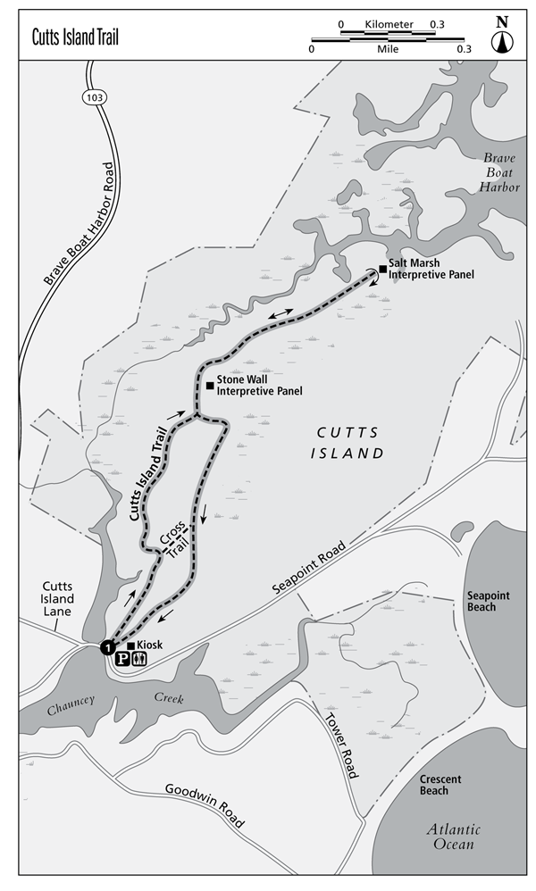
The Cutts Island Trail follows tidal Chauncey Creek, which meanders through a wide salt marsh. The trail ends at an overlook of the marsh and Brave Boat Harbor beyond. The return hike remains inland, following a low hill through mixed hardwoods.
Start: Cutts Island Trailhead on north side of Seapoint Road just east of bridge over Chauncey Creek
Distance: 2.1-mile loop
Approximate hiking time: 2 hours
Difficulty: Easy
Best season: Apr-Oct
Trail surface: Woodland path
Land status: Rachel Carson National Wildlife Refuge
Nearest town: York Village
Other users: None
Water availability: None
Canine compatibility: No dogs allowed
Fees and permits: None
Maps:DeLorme: Maine Atlas & Gazetteer map 1; USGS Kittery
Trail contact: Rachel Carson National Wildlife Refuge, (207) 646-9226, www.fws.gov/refuge/rachel_carson
Finding the trailhead: From exit 7 on the Maine Turnpike (I-95), drive 0.4 mile to US 1. Turn right onto US 1 and drive 0.3 mile. Turn left onto US 1A and drive 1.4 miles. Turn left onto ME 103 and drive 4.1 miles. Turn left onto Cutts Island Lane and drive 0.3 mile to a T-intersection. Turn left onto Seapoint Road. You will immediately cross the bridge over Chauncey Creek. The trailhead is on the left just past the bridge. GPS: N43 05.273' / W70 40.529'
The Hike
Cutts Island isnt really an island. It is a high, wooded area bounded by salt marshes and the coast. But especially at high tide, you have the feeling of being on an island as you hike along Chauncey Creek. The creek is popular with kayakers, but you will likely have the woods to yourself.
The trail is part of the Brave Boat Harbor Unit of the Rachel Carson Wildlife Refuge. The refuge is more than 14,000 acres in several units spread out along the Maine coast from Kittery to Cape Elizabeth. It was established in 1966 to protect the habitat for migratory birds. In spring and fall, you are likely to at least hear several species of warblers in the woods. Out in the salt marshes and on the water, you may find several species of waterbirds. Eagles and ospreys are not uncommon visitors.
In the woods you may see New England cottontail rabbitsone of the reasons the hike doesnt allow dogs. This species of rabbit thrived in the abandoned farms of New England, but as that disused farmland returns to forest or became subdivisions, the cottontails are becoming rare. They are currently a candidate for listing as an endangered species.
From the end of the trail, you can look across the salt marsh and watch waves roll across Brave Boat Harbor. The sound of the surf hushes across the wind-tossed grasses.
After your hike you may want to continue down Seapoint Road to Seapoint Beach. Like many Maine beaches, it is as much gravel as sand but quite picturesque.
Miles and Directions
0.0 Start from the trailhead on the north side of Seapoint Road east of the bridge over Chauncey Creek. Follow the trail along the creek, to the left of the restroom.
0.2 Bear left as you pass the Cross Trail.
0.3 The trail leaves Chauncey Creek.
0.5 Turn left at the intersection. The trail to the right will be your return route.
1.0 The trail ends at an overlook of a salt meadow with Brave Boat Harbor in the background. To complete the hike, return the way you came.
1.5 Bear left at the intersection.
1.8 Pass the Cross Trail.
2.1 Arrive back at the trailhead.
Vaughan Woods
Several miles of trails crisscross mature pine woods and meander along the tidal Salmon Falls River. The hike follows an old bridle path through the woods to the southern end of the park, passing the Warren homesite. You return to the trailhead along the river, where there are several overlooks.
Start: Marked trailhead in picnic area at east end of parking lot
Distance: 2-mile loop
Approximate hiking time: 23 hours
Difficulty: Easy
Best season: Vaughan Woods Memorial State Park is open Memorial Day to Labor Day. You can easily walk into the park when the gate is closed during the off-season.
Trail surface: Woodland path
Land status: Vaughan Woods Memorial State Park
Nearest town: South Berwick
Other users: None
Water availability: Spigot near trailhead
Canine compatibility: Dogs must be on a 4-foot leash at all times.
Fees and permits: Park entrance fee, payable at self-service kiosk
Maps:DeLorme: Maine Atlas & Gazetteer map 1; USGS Dover East
Trail contact: Vaughan Woods Memorial State Park, (207) 490-4079, www.maine.gov/doc/parks
Finding the trailhead: From exit 7 on the Maine Turnpike (I-95), drive 0.4 mile to US 1. Turn right and drive 0.7 mile south on US 1. Turn right onto ME 91 and drive 7.6 miles to the junction with ME 236. Go straight across ME 236 onto Old South Road and drive 1.1 miles. Turn left onto Oldfields Road and drive 0.4 mile. The park entrance is on the right. Drive to the far end of the parking area. The trailhead is in the picnic area at the end of the parking lot. GPS: N43 12.721 / W70 48.752
The Hike
The hike begins in a piney picnic grove. The field that you drove through to get to the trailhead is more typical of this lands historical character. Before the first European settlers, Native Americans kept open areas for farming and berrying along the Salmon Falls River. They rotated land about every ten years, leaving a patchwork of farmland, brambles, new forest, and mature forest. Later, when the Hamilton family built their house overlooking the river, almost none of the land that is now the state park was forested.
As you follow the Bridle Path through mature softwood forest, it is hard to believe it is relatively young. Just before the trail turns toward the river, you pass the Warren homesite. James Warren built a cabin here around 1656. Just to the west of the cellar hole is the family cemetery. All that remains are several tilted stones whose inscriptions have long been worn off.


