About the Authors
Linda Black Regnier divides her time between New Mexico (where she was raised) and Montana. She is an advocate for environmental and animal rights issues. Hope Di Paolo is pursuing a degree at Colgate University. They, along with husband and grandfather Jim, were grateful for an unexpected and wonderful summer together in New Mexico while writing this book. They urge those who read and use it to become involved in the work of preserving wilderness areas wherever they may be.
Acknowledgments
This third edition would not exist were it not for Jim Regnier. Linda was unable to hike due to a foot injury, so it fell to Hope and Jim to carry on. Very alike in many ways, they put their heads down, hiked uphill and down, and broke all kinds of speed records. It was difficult, therefore, to calculate approximate hiking times; we did the best guesstimate. We will happily share all royalties with Jim, husband and grandfather.
Our hike to the Pecos Wilderness was especially eventful, as we met Libby Mims and her mother, Jean Jorgenson, both with long histories in the Pecos, and Alice McSweeney, proprietor of Los Pinos Ranch, located just before Panchuela picnic ground at the Cave Creek Trailhead. We received a personal tour of this historic ranch, and we encourage you to visit www.lospinosranch.com for further information.
Our thanks to William Tefft, manager, New Mexico Public Lands Information Center in Santa Fe; Dr. Glenda King of Santa Fe Foot and Ankle Institute, who recommended a great new hike; Gregg Ohlsen of Travel Bug in Santa Fe; and, last but not least, Jandy Cox of Rocky Mountain Outfitters in Kalispell, Montana, who provided us his technical expertise.
Black Canyon Trail
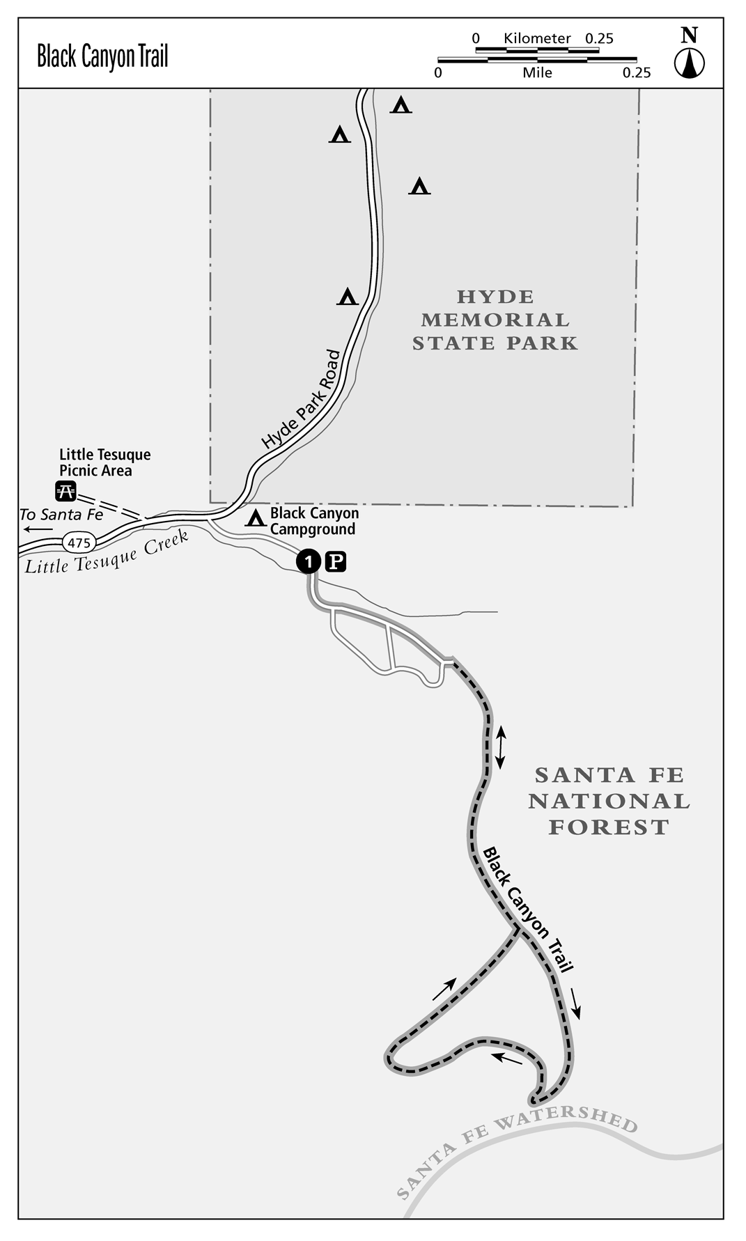
This hike, close to Santa Fe, is suitable for children, well shaded, and a good introduction to the mountain terrain, fir-aspen belt vegetation, and wildflowers of this elevation in the Sangre de Cristo Mountains. The trailhead is located in newly renovated Santa Fe National Forests Black Canyon Campground, where half of the campsites can be reserved: www.recreation.gov; (877) 444-6777. Camping here is a real treat!
Distance: 2.1-mile loop
Ascent: 342 feet
Hiking time: About 45 minutes
Difficulty: Easy
Trail surface: Dirt and rock forest trail
Best season: Spring, summer, fall
Other trail users: With the exception of designated wilderness, most National Forest trails are open to mountain biking.
Canine compatibility: Leashed dogs permitted
Fees and permits: None
Schedule: Year-round access
Maps: USGS McClure Reservoir NM; USDA Forest Service Santa Fe National Forest map. Santa Fe Mountains Trail Map, Map Adventures Maps & Guides, available at Travel Bug, 839 Paseo de Peralta, Santa Fe; (505) 992-0418; www.mapsofnewmexico.com
Trail contact: Santa Fe National Forest; (505) 438-5300. Santa Fe National Forest Espanola Ranger District; (505) 753-7331; www.fs.usda.gov/santafe
Special considerations: Can be icy in winter
Finding the trailhead: From Santa Fe Plaza, head north on Washington Avenue. At the first light after the intersection with Paseo de Peralta, turn right onto Artists Road, which becomes NM 475. At approximately 7 miles turn right (east) into Black Canyon Campground. Parking is allocated for hikers on the left, immediately before the campground entrance. Hike through the campground to the far end of loop, and the trailhead is located between campsite 24 and the bathrooms. GPS: N35 43.32 / W105 50.8
The Hike
The first section of the hike is a gradual ascent on a wide, somewhat rocky path. At about 0.3 mile there is a sign displaying a double arrow. Proceed left (southeast) for the Black Canyon Loop. The trail veers immediately to the right to ascend through a lightly wooded area. At about 0.7 mile a signpost points in the direction from which you came. Disregard and continue hiking straight. Be certain to stay on the trail, as the Santa Fe watershed is to your left and is out of bounds to hikers. A heavy fine is imposed for trespassing. As you descend for the final part of this loop trail, the trail widens, and felled trees appear on both sides. At 1.2 miles you are back at the double arrow sign. Retrace your steps to the campground.
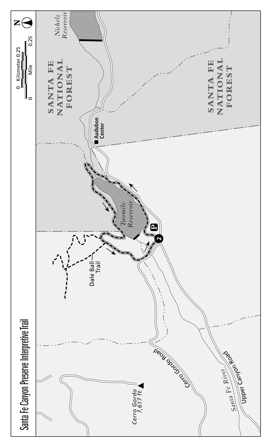
Santa Fe Canyon Preserve Interpretive Trail
This hike, tucked into the Santa Fe River canyon in the bed of a former reservoir, is very close to downtown Santa Fe and is suitable for children. With 190 acres of open space in a thriving bosque of cottonwood and willows, it is one of the last unspoiled riparian areas along the Santa Fe River. Under the ownership and management of The Nature Conservancy, there have been increasing efforts at beaver habitat restoration, and sightings are increasingly common. In addition, 140 species of birds have been found among the wetlands and ephemeral pools.
Distance: 1.5-mile loop
Ascent: 175 feet
Hiking time: About 45 minutes
Difficulty: Easy
Trail surface: Dirt
Best season: All seasons, but can get icy in winter and muddy in summer
Other trail users: None; bikes not permitted
Canine compatibility: Dogs not permitted
Fees and permits: None
Schedule: Open year-round, dawn to dusk
Maps: USGS Santa Fe; The Nature Conservancy, www.nature.org; pick up Dale Ball Trails and Connecting Trails maps at Santa Fe Convention and Visitors Bureau, 201 W. Marcy St., Santa Fe (505-955-6200) or download at www.santafe.org or www.santafenm.gov. Santa Fe City Trails Map (Map Adventures Maps and Guides) is available at Travel Bug, 839 Paseo de Peralta, Santa Fe (505-992-0418), www.mapsofnewmexico.com.
Trail contact: The Nature Conservancy, 212 E. Marcy St. #20, Santa Fe, NM 87505; (505) 988-3867
Finding the trailhead: From Santa Fe Plaza drive east on W. San Francisco Street. Turn right onto Cathedral Place, then turn left onto E. Alameda St.; drive for about 1.3 miles and turn left on Upper Canyon Rd. Drive for approximately 1 mile to the intersection of Cerro Gordo Road on the left. Turn left, and immediately on the right is a parking lot and the preserve entrance. GPS: N35 41.11 / W105 53.42
The Hike
The trailhead is clearly visible at the east end of the parking lot. Immediately an interpretive sign provides both historical and ecological information on the preserve. This is the first of many along this loop trail. Head northeast on a well-worn trail. As you hike, moisture-dependent cottonwoods, willow, and box elder line the riparian area. The trail meanders beside the stream, comes to a clearing in the willows, takes a right (heading south), and proceeds uphill for a short distance before coming to a fork in the trail. Walk to your left. You will see another historical marker, which describes the features of the old waterworks in front of you. Veering to the left (north), you will walk through a short, swampy area (in the springtime), and at the edge of the dam, three benches provide a great resting place. The trail then heads northeast along a stone-lined path and comes to another interpretative plaque at the 0.5-mile marker.


