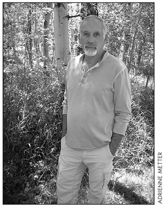
About the Author
Since 1991, Robert Stone has been writer, photographer, and publisher of Day Hike Books. He is a Los Angeles Times Best Selling Author and an award-winning journalist of Rocky Mountain Outdoor Writers and Photographers, the Outdoor Writers Association of California, the Northwest Outdoor Writers Association, the Outdoor Writers Association of America, and the Bay Area Travel Writers.
Robert has hiked every trail in the Day Hike Book series. With 20 hiking guides in the series, many in their fourth and fifth editions, he has hiked thousands of miles of trails throughout the western United States. When Robert is not hiking, he researches, writes, and maps the hikes before returning to the trails. He spends summers in the Rocky Mountains of Montana and winters on the California Central Coast.
Day Hikes On the California Central Coast...... 978-1-57342-058-7
Day Hikes On the California Southern Coast.... 978-1-57342-045-7
Day Hikes In the Santa Monica Mountains....... 978-1-57342-065-5
Day Hikes Around Sonoma County................. 978-1-57342-072-3
Day Hikes Around Napa Valley..................... 978-1-57342-057-0
Day Hikes Around Monterey and Carmel........ 978-1-57342-067-9
Day Hikes Around Big Sur............................. 978-1-57342-068-6
Day Hikes Around San Luis Obispo................. 978-1-57342-070-9
Day Hikes Around Santa Barbara.................. 978-1-57342-075-4
Day Hikes Around Ventura County................. 978-1-57342-062-4
Day Hikes Around Los Angeles...................... 978-1-57342-071-6
Day Hikes Around Orange County................. 978-1-57342-074-7
Day Hikes In Yosemite National Park............. 978-1-57342-059-4
Day Hikes In Sequoia and Kings Cany on N.P.... 978-1-57342-030-3
Day Hikes Around Sedona, Arizona............... 978-1-57342-049-5
Day Hikes In Yellowstone National Park......... 978-1-57342-048-8
Day Hikes In Grand Teton National Park......... 978-1-57342-069-3
Day Hikes In the Beartooth Mountains
Billings to Red Lodge to Yellowstone N.P...... 978-1-57342-064-8
Day Hikes Around Bozeman, Montana............ 978-1-57342-063-1
Day Hikes Around Missoula, Montana............ 978-1-57342-066-2
These books may be purchased at your local bookstore or outdoor shop. Or, order them directly from the distributor:
National Book Network
800-462-6420
Potrero John Trail
Hiking distance: 4 miles round trip
Hiking time: 2 hours
Configuration: out-and-back
Elevation gain: 600 feet
Difficulty: easy to slightly moderate, with several creek crossings
Exposure: a mix of forest and open meadow slopes
Dogs: allowed
Maps: U.S.G.S. Wheeler Springs
Matilija and Dick Smith Wilderness Map Guide
Sespe Wilderness Trail Map
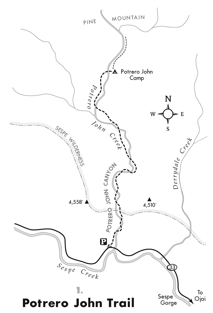
Potrero John Canyon is tucked into the southern slopes of Pine Mountain in the 220,000-acre Sespe Wilderness, part of the Los Padres National Forest. The Potrero John Trail is an uncrowded, lightly used trail that begins at an elevation of 3,655 feet, where Potrero John Creek empties into Sespe Creek. The trail follows Potrero John Creek through a narrow gorge and up the canyon. There is also an open meadow dotted with red baked manzanita and views of the surrounding mountains. At the trails end is Potrero John Camp, a creekside flat shaded with oaks.
To the trailhead
HWY 33/MARICOPA HWY OJAI 34.585009, -119.268736
From Ojai, drive 21 miles north on Highway 33 (Maricopa Highway) to the trailhead parking pullout on the right side of the road. It is located on the north side of Potrero Bridge.
The hike
Hike north past the trailhead sign, immediately entering the narrow, steep-walled canyon on the west side of Potrero John Creek. After three successive creek crossings, the trail enters the Sespe Wilderness. There are eight creek crossings in the first mile while passing various pools and cascades. At one mile, leave the narrow canyon and emerge into a large, open meadow. At the far side of the meadow, the trail ends at Potrero John Camp, a walk-in camp on the banks of the creek. Return to the trailhead along the same route.
To hike farther, a rough, unmaintained trail heads upstream over rocks, downfall, and underbrush. Along the way are continuous pools, cascades, and waterfalls.
Rose Valley Falls
Hiking distance: 1 mile round trip
Hiking time: 30 minutes
Configuration: out-and-back, with short side paths to creek
Elevation gain: 300 feet
Difficulty: easy
Exposure: shady forest
Dogs: allowed
Maps: U.S.G.S. Lion Canyon
Sespe Wilderness Trail Map
Rose Valley Falls is a 300-foot, three-tiered waterfall at the northern base of Nordhoff Ridge in the Topatopa Mountains. This hike follows Rose Valley Creek up a shady canyon to the base of the lower falls, a 100-foot, multi-strand waterfall. The tall and narrow waterfall cascades through a notch over the near-vertical cliffs onto the rocks below in a cool, moss-covered grotto. This short, easy trail begins at the Rose Valley Campground at an elevation of 3,450 feet. There are also three lakes near the campground that are stocked with trout.
To the trailhead
ROSE VALLEY LAKE RD OJAI 34.531730, -119.182845
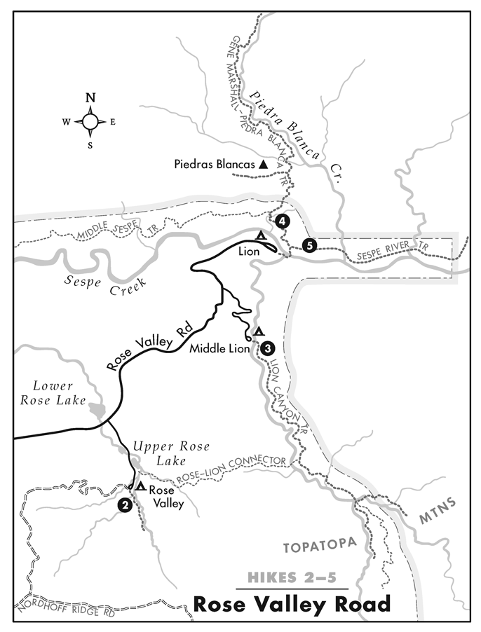
From Ojai, drive 14.6 miles north on Highway 33 (Maricopa Highway) to the Rose Valley Road turnoff and turn right. Continue 3 miles to the Rose Valley Campground turnoff across from the lower lake and turn right. Drive 0.5 miles to the south end of the campground loop road to the signed trailhead by campsite number 4.
The hike
Hike south past the trailhead sign, immediately entering the thick coastal live oak, bay, and sycamore forest on the well-defined trail. Cross a tributary of Rose Valley Creek, and stay on the main path as you make your way up the lush, narrow canyon. The first of several small waterfalls can be spotted on the left at 0.2 miles. Short side paths lead down to the creek by these waterfalls and pools. The trail ends at a half mile at the base of lower Rose Valley Falls with its bridal veil beauty, beneath the colorful mossy rock wall. Return along the same path.
To extend the hike, the Nordhoff Road (a gated road) climbs 2.1 miles west to Nordhoff Ridge, with sweeping coastal and mountain vistas. At the entrance gate to the campground, the Rose-Lion Connector Trail heads east to Lion Canyon (hike 3).


