About the Author
Since 1991, Robert Stone has been writer, photographer, and publisher of Day Hike Books. He is a Los Angeles Times Best Selling Author and an award-winning journalist of Rocky Mountain Outdoor Writers and Photographers, the Outdoor Writers Association of California, the Northwest Outdoor Writers Association, the Outdoor Writers Association of America, and the Bay Area Travel Writers.
Robert has hiked every trail in the Day Hike Book series. With 20 hiking guides in the series, many in their fourth and fifth editions, he has hiked thousands of miles of trails throughout the western United States. When Robert is not hiking, he researches, writes, and maps the hikes before returning to the trails. He spends summers in the Rocky Mountains of Montana and winters on the California Central Coast.
Mill Creek Trail
Hiking distance: 3 miles round trip
Hiking time: 2 hours
Configuration: out-and-back
Elevation gain: 600 feet
Difficulty: easy to slightly moderate
Exposure: shaded canyon
Dogs: allowed
Maps: U.S.G.S. Cape San Martin Ventana Wilderness map
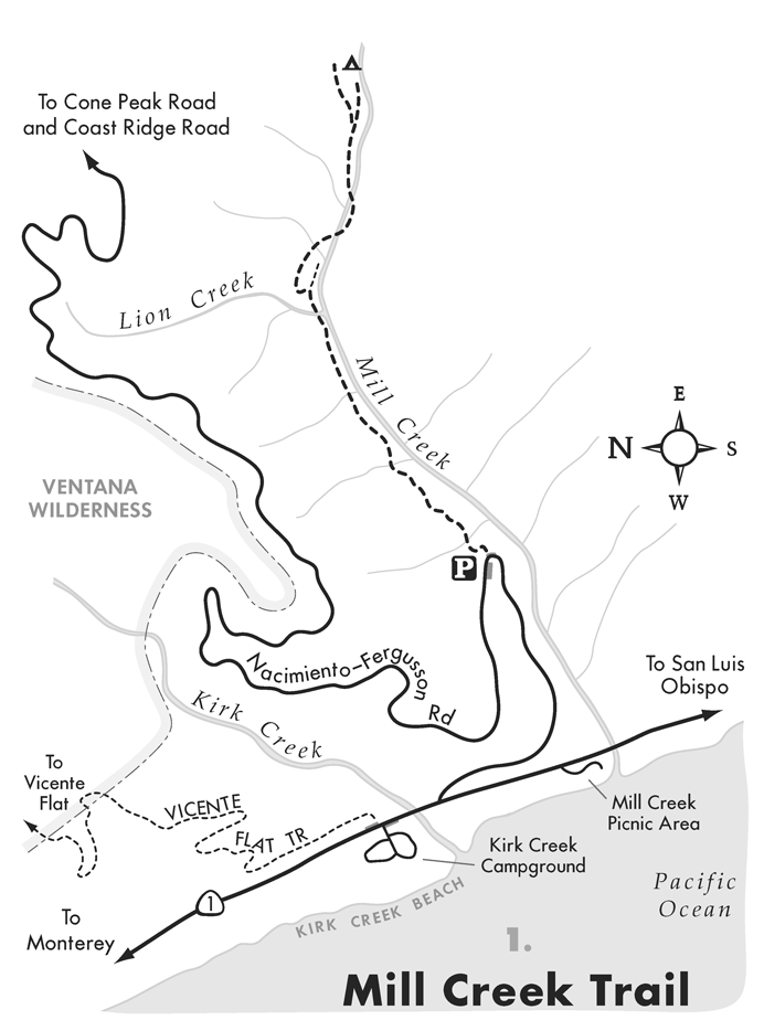
The Mill Creek Trail follows the bucolic watershed up beautiful Mill Creek Canyon just south of Nacimiento-Fergusson Road in Monterey County. The canyon was named for an old sawmill that once produced railroad ties. The trail meanders alongside Mill Creek through riparian vegetation under the dark shade of giant redwoods, big leaf maples, and sycamores. The hike ends at a campsite perched above the creek amidst a cluster of redwoods.
To the trailhead
BIG SUR RANGER STATION . From the ranger station, located 27 miles south of Carmel, drive 27.4 miles south on Highway 1 to Nacimiento-Fergusson Road. The road is 0.2 miles south of Kirk Creek Campground. Turn inland and wind up the paved mountain road 0.8 miles to the posted trail on the right, at a distinct left horseshoe bend. Park in the pullout on the right by the trailhead.
RAGGED POINT . Ragged Point is located 23 miles north of Cambria and 1.5 miles south of the Monterey County line. From Highway 1 at Ragged Point, drive 20.2 miles north to Nacimiento-Fergusson Road, located 4.2 miles north of the Pacific Valley Ranger Station.
The hike
Climb 100 yards up the steep slope to a small saddle. Descend under a canopy of California bay laurel. The undulating path follows the north canyon wall high above Mill Creek. The creek can be heard but not yet seen, as towering redwoods carpet the canyon floor. Gradually drop down the hillside into a wet, lush forest of redwoods, maples, sycamores, bracken and sword ferns, and moss-covered granite rocks at a half mile. Wind through the canyon, following the creek upstream. Rock hop over Lion Creek to a distinct but unmarked trail fork. Take the left fork and climb up a 1 5-foot slope. (The right fork ends 30 yards ahead.) Curve right, soon reaching a creek crossing. Rock hop over Mill Creek two consecutive times while passing waterfalls and pools. Scramble over a jumble of boulders at an old landslide, then follow a narrow ledge on the edge of the creek. The main trail curves to a plateau above the creek, where there is a gorgeous campsite surrounded by a cluster of redwoods. This is the turn-around spot and a great place to explore the immediate surroundings. The trail continues up to the South Coast Ridge Road, but it becomes indistinct just beyond the camp.
Prewitt Loop Trail to Stag Camp NORTH TRAILHEAD
Hiking distance: 8 miles round trip
Hiking time: 5 hours
Configuration: out-and-back
Elevation gain: 1,700 feet
Difficulty: moderate to strenuous
Exposure: mix of exposed hillside and forested pockets
Dogs: allowed
Maps: U.S.G.S. Cape San Martin
Big Sur and Ventana Wilderness map
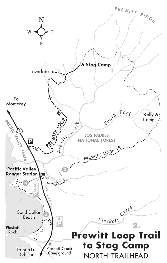
The Prewitt Loop Trail is a 12.8-mile loop located in the heart of Pacific Valley at the south end of the Big Sur coast. The trail circles the Prewitt Creek watershed through a mix of habitats in the Los Padres National Forest. This hike begins from the north trailhead on the sloping oceanfront grasslands with coastal scrub. The lightly used footpath leads up the canyon through oak, pine, and laurel woodlands; groves of redwoods; and grassy savannas. The trail leads 4 miles up the remote north slope of Prewitt Creek Canyon to Stag Camp, perched in an oak grove on the upper mountain slopes. Although the trail gains 1,700 feet, it is never steep and offers magnificent vistas. The views span across Pacific Valley to the scalloped coastline, including Plaskett Creek, crescent-shaped Sand Dollar Beach, and north to Lopez Point.
To the trailhead
BIG SUR RANGER STATION . From the ranger station, located 27 miles south of Carmel, drive 30.6 miles south on Highway 1 to the signed trailhead on the left (inland). The trailhead is located 3.8 miles south of the Kirk Creek Campground and 0.5 miles north of the Pacific Valley Ranger Station. Park in the pullouts along either side of the road.
RAGGED POINT . Ragged Point is located 23 miles north of Cambria and 1.5 miles south of the Monterey County line. From Highway 1 at Ragged Point, drive 16.4 miles north to the trailhead on the right (inland). The trailhead is 0.5 miles north of the Pacific Valley Ranger Station.
The hike
Walk through the signed trailhead gate and up the grassy path along the base of the mountains. Traverse the chaparral-clad slope, with a view across Pacific Valley, the scalloped coastline, the circular-shaped Sand Dollar Beach, and the offshore rock formations. Wind up the mountain on an easy grade that offers steady views of the ocean. Weave along the curvature of the mountain through thickets of low-lying coastal scrub. Curve left on the upper northwest wall of forested Prewitt Creek Canyon. The views stretch up the canyon from the ocean to the ridge. The canyon soon forks into two drainages. Veer left, following the west fork. Enter the shade of an oak, pine, bay laurel, and redwood forest with a lush understory of ferns. Pass through a trail gate and continue gaining altitude. Cross a fork of Prewitt Creek on a horseshoe right bend at 2.7 miles to a distinct spur trail on the left. The side path climbs a short distance to a grassy saddle with views in every direction.
On the main trail, cross a series of gullies and emerge onto the open grassy slopes with exceptional vistas. Pass between two spring-fed water troughs with a view down canyon of Sand Dollar Beach. A quarter mile past the spring, in a small forested flat, is Stag Camp on the right. The primitive camp contains a fire pit and picnic bench. This is the turn-around spot.


