About the Authors
WeHeidi Radlinski and Mary Skjelsethave been exploring and documenting Mount Rainier for twenty years. At the tender age of 19, we were approached by Falcon Press to write a guidebook to Mount Rainier National Park. Heidi was a college student at Lewis and Clark in Portland, Oregon; Mary attended Reed College across town. In the summer of 1998, we traversed every foot of trail in Mount Rainier National Park and wrote two guides based on the knowledge and information we gathered during our back-breaking adventures. At that time, we were the youngest author team to complete a FalconGuide. Needless to say, we are no longer the youngest authors.
Decades later, Heidi is a family medicine physician, who delivers babies, serves families, and instructs residents in Southwest Washington. Mary is a civil rights lawyer in Portland, OR. Now, we take our creaky knees and growing families into the park to revise the guides, and we enjoy every second of the arduous work. With this guide, may you find yourself a bit more prepared for your adventure on the mountain, and may you fall in love with this place, like we have.
A Note on Your Furry Friends
If you love hiking with your loyal companion, Mount Rainier is not your ideal destination. To preserve wildlife, the National Park Service prohibits pets on trails, in the wilderness and/or off-trail areas, inside buildings, in amphitheaters and on snow-covered roads closed for winter (except designated snowmobile routes). Therefore, the vast majority of trails and land in the park remains off-limits to your furry friend. There are a few, narrow exceptions:
Pacific Crest TrailDogs are permitted on the Pacific Crest Trail (PCT). They must be on a leash no longer than 6 feet. Of the Best Easy Day Hikes in this book, only Hike 19: Naches Peak has a portion of the trail outside the park or along the PCT.
Designated snowmobile routesIn winter, you may bring a dog along the designated snowmobile routes once the following roads are covered with snow: Road to Round Pass, Cougar Rock Campground Loops, WA 123 to Stevens Canyon Road as far as Box Canyon, and WA 410 from the north boundary to White River Road as far as the White River Campground.
Service animalsA service dog is allowed on trails and facilities if the dog has been trained to do work or perform tasks for the benefit of an individual with a disability. This does not include therapy animals that provide emotional support.
Pets are permitted in parking lots, campgrounds, and on paved roads. However, at all times they must be leashed or crated and with their owners.
For more information, visit https://www.nps.gov/mora/planyourvisit/pets.htm.
Twin Firs Loop
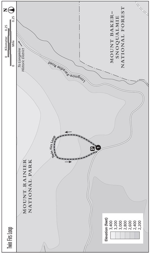
This short loop circles a low-elevation old-growth forest dominated by western red cedar and Douglas fir that reach for the sky, and vine maple, skunk cabbage and giant ferns that carpet the forest floor.
Start: Twin Firs Loop Trailhead
Distance: 0.4-mile loop
Hiking time: 20 minutes
Trail surface: Well maintained; forest floor
Elevation gain: Minimal
Best season: May through Oct
Nearest town: Ashford
Fees and permits: Vehicle or individual entry fee (seven days); annual entry pass available for purchase
Trail contacts: Longmire Wilderness Information Center, (360) 569-6650
Trail conditions: www.nps.gov/mora/planyourvisit/trails-and-backcountry-camp-conditions.htm; weather, www.nps.gov/mora/planyourvisit/weather.htm
Finding the trailhead: From the Nisqually Entrance Station, drive east for 4.5 miles on the Longmire-Paradise Road. You will see a turnout on the left of the road. If you reach the Longmire Historic District, you have gone too far. GPS: N46 44.012' / W121 50.296'
The Hike
An easy and educational stroll through low-elevation forest, the Twin Firs Loop sees many tourists who stop for a brief walk before reaching the Longmire Historic District. The trail is especially popular with families, since even the littlest visitors can hike the entire length and feel triumphant at the end.
At the trailhead, take the time to read an exhibit describing the flora of low-elevation forests. Through pictures and written description, the exhibit explains how to differentiate Douglas fir, western hemlock, and western red cedar.
The trail weaves around majestic trees, some fallen and some standing tall. You will see mossy logs and big ferns lining both sides of the trail. Less than halfway into your hike, a log takes you across a small creek to where the trail becomes steeper. You will cross this gurgling creek again just before you return to the Longmire-Paradise Road, directly west of where you began your hike.
Miles and Directions
0.0 Start at the Twin Firs Loop Trailhead.
0.4 Arrive back at Longmire-Paradise Road.
Rampart Ridge
One of the few hikes that is clear of snow in June, this short but steep trek up to Rampart Ridge affords you splendid views of Eagle Peak, Mount Rainier, and the Nisqually River Valley.
Start: Longmire Historic District
Distance: 5.1-mile loop
Hiking time: 23 hours
Trail surface: Well maintained; forest floor
Elevation gain: 1,280 feet
Best season: June through Sept
Nearest town: Ashford
Fees and permits: Vehicle or individual entry fee (seven days); annual entry pass available for purchase
Trail contacts: Longmire Wilderness Information Center, (360) 569-6650
Trail conditions: www.nps.gov/mora/planyourvisit/trails-and-backcountry-camp-conditions.htm; weather, www.nps.gov/mora/planyourvisit/weather.htm.
Finding the trailhead: From Nisqually River Entrance Station, drive 6.7 miles east on the Longmire-Paradise Road to the Longmire Historic District. Turn right (southeast) into the parking lot around the Longmire Historic District, which includes Longmire Wilderness Information Center, the Longmire Museum, and the National Park Inn. Walk on one of the two crosswalks across the Longmire-Paradise Road to the Rampart Ridge Trailhead, located across the street from the inn. GPS: N46 45.013' / W121 48.786'
The Hike
This hike is great for people who like to climb hills, enjoy great scenery, and need a hike that is snow-free in June. In less than 2 miles, the trail takes you up 1,200 feet and allows you to peer into the valley you just ventured from, as well as the valley on the other side of Rampart Ridge. The ridge itself, also known as the Ramparts, is a remnant of ancient lava flow from Mount Rainier. The switchbacks are steep but definitely bearable. Remember to bring plenty of water, because the only water sources arise toward the end of the hike.
We recommend that you hike this trail clockwise to keep possible views of Mount Rainier in front of you. To increase educational opportunities along the hike, we also recommend that you walk the greater part of the Trail of the Shadows. The Trail of the Shadows tells the tale of James Longmires settlement of the valley where the Longmire Historic District now stands. This tale is told via informational signs posted at points of interest along the way and provides something to think about during your workout ahead.
To start the hike, cross any of the well-marked crosswalks in front of the Longmire Historic District across the Longmire-Paradise Road. Stay to the right (north) until you reach the Trail of the Shadows Trailhead. The Trail of the Shadows (described in detail as Hike 3) is a self-guided hike that loops around a field of mineral springs, past the Longmire cabin, Iron Mike, and the Travertine Mound to the junction with the Rampart Ridge Trail.


