The author has a serious problemhe doesnt know what he wants to do when he grows up. Meanwhile hes done such things as wildland firefighting, running a mountain shop, flying airplanes, shooting photos, and writing books. Hes a back-country skier, climber, figure skater, mountain biker, amateur radio operator, river runner, and sea kayakerbut the thing that really floats his boat is hiking and backpacking. No matter what else he tries, the author always come back to hiking, especially long, rough, cross-country trips in places like the Grand Canyon. Some people never learn. But what little he has learned, hes willing share with youvia his books, of course, but also via his website, blogs, and whatever works. His website is BruceGrubbs.com.
Id like to thank all the USDA Forest Service and other agency personnel who made valuable comments and suggestions. Warm thanks to Duart Martin for encouraging this project, not to mention hiking with me. Thanks to Marvin and Sharon Baur for doing shuttles and hikes, and thanks to all my other hiking companions over the years. It wouldnt have been nearly as much fun without you. Thanks to David Legere and my other editors for working with me to make this the best possible book. I really appreciate Melissa Baker and her staff cartographers for the excellent maps. Finally, I greatly appreciate the production people at Rowman & Littlefield, who worked hard to turn my rough manuscript into another fine FalconGuide.
Hiking Nevada: A Guide to States Greatest Hiking Adventures, 3rd edition
Best Easy Day Hikes Tucson, 2nd Edition
Hiking Arizona: A Guide to the States Greatest Hiking Adventures, 4th edition
Basic Illustrated Using GPS, 3rd Edition
Hiking Arizonas Superstition and Mazatzal Country: A Guide to the Areas Greatest Hikes, 2nd edition
Camping Arizona: A Comprehensive Guide to Public Tent and RV Campgrounds, 3rd edition
Camping Southern California: A Comprehensive Guide to Public Tent and RV Campgrounds, 2nd edition
Best Hikes Near Las Vegas
Backpacker Magazines Using a GPS: Digital Trip Planning, Recording, and Sharing
Best Easy Day Hikes Palm Springs and Coachella Valley
Best Easy Day Hikes Las Vegas
Best Easy Day Hikes Albuquerque
Best Easy Day Hikes Sedona, 2nd edition
Best Easy Day Hikes Flagstaff, 2nd edition
Best Hikes Near Phoenix
Hiking Northern Arizona: A Guide to Northern Arizonas Greatest Hiking Adventures, 3rd edition
Grand Canyon National Park Pocket Guide
Explore! Joshua Tree National Park: A Guide to Exploring the Desert Trails and Roads
A FalconGuide to Saguaro National Park and the Santa Catalina Mountains
A day hike along lower Oak Creek through a historic property that is now an Arizona state park.
Distance: 2.0-mile lollipop
Hiking time: About 1 hour
Difficulty: Easy
Seasons: Year-round
Trail surface: Dirt and rocks
Water: Visitor center
Other trail users: None
Canine compatibility: Dogs not allowed in order to protect wildlife
Land status: Red Rock State Park
Fees and permits: Entrance fee
Maps: Trails Illustrated Flagstaff and Sedona; USGS Sedona; Red Rock State Park brochure
Trail contacts: Red Rock State Park, 4050 Red Rock Loop Rd., Sedona 86336; (928) 282-6907; azstateparks.com/red-rock
Finding the trailhead: From Sedona, go west on AZ 89A to the lower Red Rock Loop Road, which is signed for Red Rock State Park. Turn left (south) and continue 2.9 miles, then turn right on the Red Rock State Park road. Continue past the entrance station to the end of the road at the visitor center. GPS: N34 48.703 / W111 49.732
The Hike
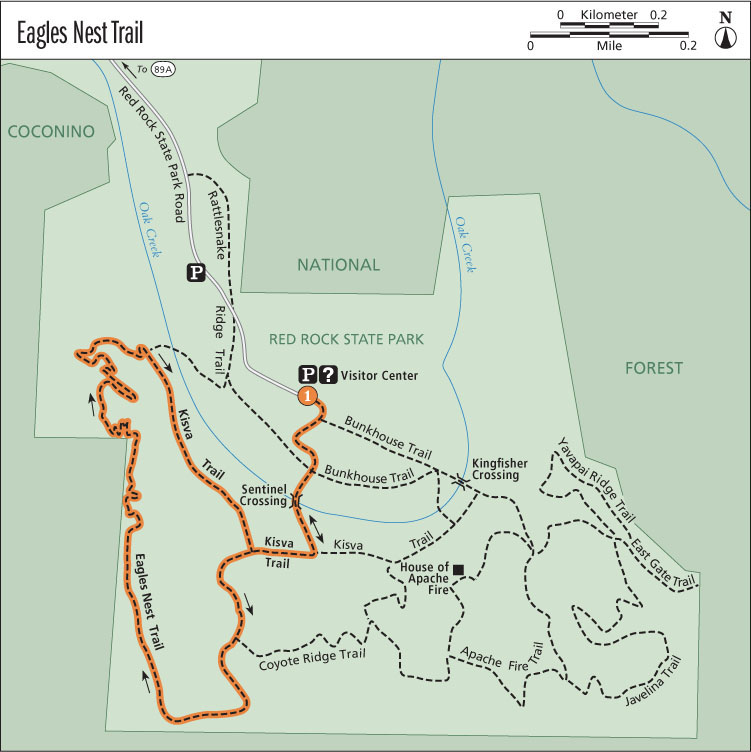
From the visitor center, follow the main trail downhill toward Oak Creek. Turn right at a junction, and cross Oak Creek on a low bridge at Sentinel Crossing. Notice the flood debris piled up from the huge flood that roared down the creek in the winter of 1993. Geologists once thought such floods were very rare and called them 1,000-year events. Today its commonly accepted that such large floods occur every few decades and are responsible for much of the erosion that takes place in the desert. Not surprisingly, the plants that grow in and along canyon bottoms such as Oak Creek are adapted to floods. Many of the larger trees survive the floods, and smaller plants that are swept away quickly regenerate from their roots.
On the far side of the creek, turn right (west) on the signed Kisva Trail. Continue a short distance then turn left (south) on the signed Eagles Nest Trail. This trail crosses an irrigation ditch then climbs away from the creek via several short switchbacks. At the signed junction with the Coyote Ridge Trail, turn right (south). The Eagles Nest Trail eventually turns northwest and works its way onto a ridge with a fine view of Oak Creek in the foreground and Cathedral Rock in the distance. Continue north as the trail descends to Oak Creek, crosses the ditch, and meets the Ridge Trail. Stay right here on the Kisva Trail. The Kisva Trail turns southeast to follow the creek. At the junction with the Eagles Nest Trail Trail, youve completed the loop. Turn left and retrace your steps to return to the visitor center.

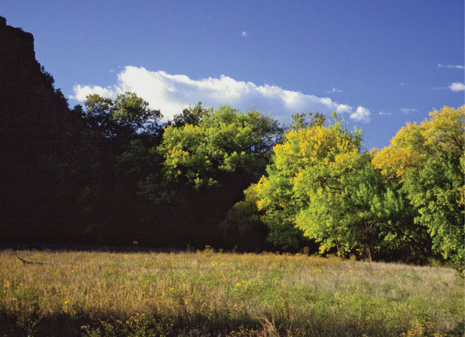
Riparian meadow along the Eagles Nest Trail
History
Dedicated in 1991, Red Rock State Park is one of the newest additions to Arizonas state park system. Originally the area was part of a working ranch. In 1941 Jack and Helen Frye purchased the Smoke Tree Ranch and built the House of Apache Fire, which still stands on the bluffs south of Oak Creek. The Fryes, whose primary home was on the East Coast, used the Smoke Tree Ranch as a vacation escape from Jacks duties as president of Trans World Airlines. In the 1970s, after Jacks death, a developer purchased 330 acres of the ranch from Helen Frye but had to sell the property when plans to develop a resort fell through. Another portion ended up being owned by Eckankar, a religious group, which intended to develop a retreat for their members.
Things came to a head in 1980 when then-governor Bruce Babbitt was hiking in the area with friends; advised that he was trespassing on private land, he was asked to leave. Impressed with the areas beauty and its potential for public recreation, the governor approached the Arizona State Parks Board about the possibility of the state buying the land for a park. This was complicated by the fact that there were two separate properties that straddled two counties, Coconino and Yavapai, and the parks board didnt have the authority to buy land across county lines. Over a period of eleven years, complex negotiations took place that involved one private owner buying another of the parcels; ultimately a bill was passed through the state legislature to authorize the various purchases and land trades. This bill also specified how the future park would be developed.

One of the key features of the bill was the requirement that existing structures be used as much as possible for the new parks facilities, partly to preserve them for historic purposes and also to lower the cost of creating the park.
Red Rock State Park was finally dedicated on October 19, 1991. The Miller Visitor Center was named for Duane Miller, who served on the Arizona State Parks Board for twenty-five years, in recognition of his and his familys service to the state park system.


