The author, Bruce Grubbs, has a serious problemhe doesnt know what he wants to do when he grows up. Meanwhile, hes done such things as wildland firefighting, running a mountain shop, flying airplanes, shooting photos, and writing books. Hes a backcountry skier, climber, figure skater, mountain biker, amateur radio operator, river runner, and sea kayakerbut the thing that really floats his boat is hiking and backpacking. No matter what else he tries, the author always come back to hikingespecially long, rough, cross-country trips in places like the Grand Canyon. Some people never learn. But what little he has learned, hes willing share with youvia his books, of course, but also via his websites, blogs, and whatever works. His website is Bruce-Grubbs.com.
Special thanks to Don Bolton of Valley of Fire State Park for reviewing the manuscript. I would like to thank my many hiking companions down the years whove put up with my incessant trail mapping and photography. Thanks to Duart Martin for her support and encouragement. And finally, thanks to my editors at Falcon Guides, Emily Chiarelli, Mason Gadd and John Burbidge, for making a book out of my rough manuscript.

T his small but spectacular unit of the Nevada state park system is located northeast of Las Vegas and is reached via I-15. The park gets its name from the red sandstone formations found in the park. The dome-shaped formations are often referred to as slickrock. Up close, sandstone is anything but slick, so the term probably relates to the rounded shapes carved out of the soft rock by the forces of erosion. Other sedimentary rock, including shale and limestone, contribute their own colors and shapes to this desert landscape. The landscape is so striking that a number of movies have been shot here.
Evidence of prehistoric people is found in the park in the form of rock art decorating several sites. The main period of occupation, by the Basketmaker and Anasazi cultures, appears to have been from 300 BC to AD 1150. Because of the dry desert climate and the general lack of reliable surface water, most native use was probably transitory. Remember that all artifacts are protected by law and should not be disturbed.
Spring and fall are the ideal times to visit Valley of Fire. The weather is generally stable and mild. Winter is not a bad time, as snow is rare in the park. Summers are hot, and hiking is best done early in the day.
The park has several picnic areas, for those who want to relax at a shaded facility before or after their hike. The park also has two campgrounds, which are first come, first served. Campfires are not allowed outside of the two campgrounds. There are also a number of points of interest accessible from the park road, including the petroglyphs at Atlatl Rock, the Beehives formations, the old CCC cabins, the Clark Memorial honoring a pioneer traveler, the Petrified Logs, Rainbow Vista, and the Seven Sisters formations.
A day hike on an interpretive trail in Valley of Fire State Park, this short walk features petrified sand dunes, prehistoric petroglyphs, and natural water tanks.
Distance: 0.8 mile out and back
Hiking time: About 1 hour
Difficulty: Easy
Trail surface: Dirt and rocks
Best season: Fall through spring
Water availability: None
Other trail users: None
Canine compatibility: Dogs allowed, on leashes 6 feet in length or less
Fees and permits: Entrance fee
Maps: CalTopo.com MapBuilder Topo layer; USGS Valley of Fire East, Valley of Fire West
Trail contacts: Valley of Fire State Park, 29450 Valley of Fire Rd., Overton 89040; (702) 397-2088; http://parks.nv.gov/parks/valley-of-fire
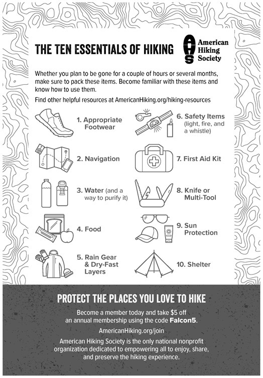
Special considerations: During the summer, hike early in the day and carry plenty of water.
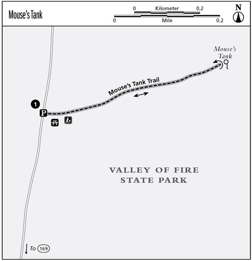
Finding the trailhead: From the intersection of US 95 and I-15 in downtown Las Vegas, drive 32.8 miles north on I-15. Turn right on NV 169, the Valley of Fire Highway, and drive 19.0 miles. Turn left on the road to the visitor center and Fire Canyon/White Domes. Continue past the visitor center 1.3 miles and park at the Petroglyph Canyon / Mouses Tank Trailhead, on the right. GPS: N36 26.463' / W114 30.974'
The Hike
The trail follows Petroglyph Canyon east from the parking area. Brochures are available at the trailhead explaining various features along this short walk. The brochure points out a couple of petroglyphs along the way, but sharp-eyed hikers will see several more. After a relatively straight section, the wash veers sharply left and, in a few dozen yards, drops into the first of several natural water tanks. This water may seem stagnant and uninviting (and is not currently safe to drink), but it would become infinitely more valuable if one was on foot many miles from civilization.
In 1897 Mouse, a Paiute Indian who was suspected of several crimes, hid out in the intricate Valley of Fire area to avoid capture. He used this water tank and probably others to survive in this nearly waterless area.
The striking red rocks of the Valley of Fire are Aztec Sandstone, which is composed of petrified sand dunes. Tiny grains of windblown sand make up the rock, and the sloping surfaces of the ancient sand dunes are clearly visible in the rock faces along the trail. The forces of erosion, primarily that of water, have acted over millions of years to sculpt the soft rock into the weird shapes found in the park.
In the backcountry, the hiker will encounter artifacts of various ages. Some of these structures, tools, and other artifacts date from before European discovery of the Americas. Others were built by early settlers and explorers. All are valuable links with our history and prehistory. Yet increasingly this evidence of early civilization is being destroyed by vandals. Federal and state laws have been passed to protect such antiquities, but ultimately the responsibility must lie with the users of the backcountry. Keep in mind that the relationships between artifacts in a site are often more important than the artifacts themselves. Petroglyphs (rock carvings) and pictographs (rock drawings) have lasted thousands of years but are easily destroyed by thoughtless people.
Miles and Directions
0.0 Leave Mouses Tank Trailhead and follow Mouses Tank Trail east.
0.3 The trail and the wash veer sharply left.
0.4 Youll reach Mouses Tank, the destination for the hike; return the way you came.
0.8 Arrive back at Mouses Tank Trailhead.
This loop hike takes you through the White Domes area in the primitive and less-traveled northern area of the park, featuring sandstone formations with brilliant and contrasting colors.
Distance: 1.5-mile loop
Hiking time: About 1 hour
Difficulty: Easy
Trail surface: Dirt and rocks
Best season: Fall through spring
Water availability: None
Other trail users: None
Canine compatibility: Dogs allowed, on leashes 6 feet in length or less
Fees and permits: Entrance fee
Maps: CalTopo.com MapBuilder Topo layer; USGS Valley of Fire East, Valley of Fire West
Trail contacts: Valley of Fire State Park, 29450 Valley of Fire Rd., Overton 89040; (702) 397-2088; http://parks.nv.gov/parks/valley-of-fire


